2012-09-28 33 -117
| Fri 28 Sep 2012 in 33,-117: 33.1261583, -117.3304991 geohashing.info google osm bing/os kml crox |
Location
In a field near Carlsbad State Beach.
Participants
- Stephen Cerruti with A'
Plans
I started off the morning checking for an accessible point and was pleased to discover via Street View that the point not only fell on land, but that the field it was in contained a sign that indicated it was public property. I planned to drive to the hash after dropping D* at school. Since A' is not attending school he has to accompany me. We count the time spent walking as P.E. time.
Expedition
I was hoping that I could do a Tron achievement without much planning but blew it because there was no parking on the street next to the field. That led me to crossing my path to find a parking space. We entered the field and found the spot pretty easily. There had been some fog on the way, but it was burning off pretty quickly. Once we snapped our photos and returned to the car we were able to locate a nearby geocache, but not so close to earn the Hash Collision achievement.
- -- Stephen Cerruti @33.1261,-117.3305 11:53, 28 September 2012 (EDT)
Photos

Smiling faces. @33.1261,-117.3305
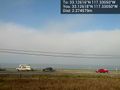
The beach, or rather a think marine layer over the ocean. @33.1262,-117.3305
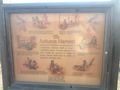
Sign at entrance to field. @33.1263,-117.3309
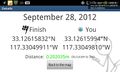
GeohashDrpid details page at the hashpoint @33.1262,-117.3305
Geohash Droid map at the hashpoint @33.1262,-117.3305
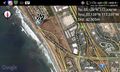
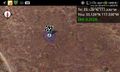
Geohash Droid map, zoomed out further, near the hashpoint @33.1263,-117.3309


Achievements
Stephen Cerruti) earned the Hash collision honorable mention
|