Difference between revisions of "2012-09-29 38 -121"
imported>Chandru (This is an interesting house... [http://www.openstreetmap.org/?lat=38.57111209&lon=-121.75471969&zoom=16&layers=B000FTF @38.5711,-121.7547]) |
imported>FippeBot m (Location) |
||
| (10 intermediate revisions by 2 users not shown) | |||
| Line 1: | Line 1: | ||
| − | {{Advert}} | + | <!--{{Advert}}--> |
| − | |||
| − | |||
| − | |||
| − | |||
| − | |||
| − | |||
{{meetup graticule | {{meetup graticule | ||
| lat=38 | | lat=38 | ||
| Line 13: | Line 7: | ||
}} | }} | ||
| − | |||
__NOTOC__ | __NOTOC__ | ||
== Location == | == Location == | ||
| − | Anderson Road between Catalina Drive and F Street, North Davis. | + | Anderson Road between Catalina Drive and F Street, North Davis. |
| + | |||
== Participants == | == Participants == | ||
[[User:Chandru | Chandru]] | [[User:Chandru | Chandru]] | ||
| Line 24: | Line 18: | ||
== Expedition == | == Expedition == | ||
| − | + | When I checked on the coordinate calculator, I saw that the geohash point was only 1.7 miles away. This is the closest that it's ever been to me, so I felt that it was imperative that I go. | |
| − | + | I immediately asked my friends if they wanted to go. Surprisingly, 2 of them said yes, and asked their roommate to come along. (I have not posted any pictures of them online, upon their request). We all decided to meet up at Northstar Park, just 155 meters from the hashpoint. Half of us walked (including me), and half biked. | |
| − | + | ||
| + | Once at the park, we had a picnic, satisfying the Picnic Achievement. They are better cooks than I am, and probably will be. | ||
| + | |||
| + | After that we went to the hashpoint. It was in the middle of the road on Anderson. After annoying all of the drivers, we managed to get to the hashpoint. Then we took pictures and went our respective ways. I went to explore further the bike paths of North Davis, and to see the weird Domino Sculpture. | ||
== Photos == | == Photos == | ||
| − | + | ||
| − | |||
| − | |||
<gallery perrow="5"> | <gallery perrow="5"> | ||
| + | Image:2012-09-29_38_-121_15-37-02-539.jpg | Tried to get GeoSquishy at the 76. They had stuff that was frozen and carbonated, but not both. [http://www.openstreetmap.org/?lat=38.56152872&lon=-121.77005367&zoom=16&layers=B000FTF @38.5615,-121.7701] | ||
| + | Image:2012-09-29_38_-121_16-32-28-324.jpg | This is an interesting house... [http://www.openstreetmap.org/?lat=38.57111209&lon=-121.75471969&zoom=16&layers=B000FTF @38.5711,-121.7547] | ||
| + | Image:2012-09-29_38_-121_16-48-10-066.jpg | Our picnic! [http://www.openstreetmap.org/?lat=38.57120784&lon=-121.75450838&zoom=16&layers=B000FTF @38.5712,-121.7545] | ||
| + | Image:2012-09-29_38_-121_17-49-01-096.jpg | I'm here! | ||
| + | |||
| + | -Chandru [http://www.openstreetmap.org/?lat=38.57183465&lon=-121.75600558&zoom=16&layers=B000FTF @38.5718,-121.7560] | ||
| + | |||
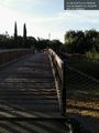
| + | Image:2012-09-29_38_-121_18-02-59-710.jpg | I did not know this bridge was here... [http://www.openstreetmap.org/?lat=38.56990172&lon=-121.76136157&zoom=16&layers=B000FTF @38.5699,-121.7614] | ||
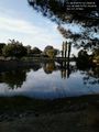
| − | Image:2012-09-29_38_- | + | Image:2012-09-29_38_-121_18-03-56-812.jpg | Same with the lake. [http://www.openstreetmap.org/?lat=38.56990796&lon=-121.76135746&zoom=16&layers=B000FTF @38.5699,-121.7614] |
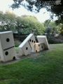
| − | Image:2012-09-29_38_- | + | Image:2012-09-29_38_-121_18-21-18-465.jpg | According to Daviswiki, these are supposed to have Satanic messages on them. [http://www.openstreetmap.org/?lat=38.56571786&lon=-121.76336806&zoom=16&layers=B000FTF @38.5657,-121.7634] |
</gallery> | </gallery> | ||
== Achievements == | == Achievements == | ||
{{#vardefine:ribbonwidth|800px}} | {{#vardefine:ribbonwidth|800px}} | ||
| − | |||
| + | {{Walk geohash | ||
| + | | latitude = 38 | ||
| + | | longitude = -121 | ||
| + | | date = 2012-09-29 | ||
| + | | name = Chandru | ||
| + | }} | ||
| + | |||
| + | {{Picnic_geohash | ||
| + | | latitude = 38 | ||
| + | | longitude = -121 | ||
| + | | date = 2012-09-29 | ||
| + | | name = Chandru | ||
| + | | image = 2012-09-29_38_-121_16-48-10-066.jpg | ||
| + | }} | ||
| − | + | {{drag-along | |
| − | + | | latitude = 38 | |
| − | + | | longitude = -121 | |
| + | | date = 2012-09-29 | ||
| + | | name = Chandru | ||
| − | + | }} | |
| − | |||
[[Category:Expeditions]] | [[Category:Expeditions]] | ||
| − | |||
[[Category:Expeditions with photos]] | [[Category:Expeditions with photos]] | ||
| − | |||
| − | |||
| − | |||
| − | |||
| − | |||
[[Category:Coordinates reached]] | [[Category:Coordinates reached]] | ||
| − | + | {{location|US|CA|YO}} | |
| − | |||
| − | |||
| − | |||
| − | |||
| − | |||
| − | |||
| − | |||
| − | |||
| − | |||
| − | |||
| − | |||
| − | |||
| − | |||
| − | |||
| − | |||
| − | |||
| − | |||
Latest revision as of 06:20, 13 August 2019
| Sat 29 Sep 2012 in 38,-121: 38.5718737, -121.7560506 geohashing.info google osm bing/os kml crox |
Location
Anderson Road between Catalina Drive and F Street, North Davis.
Participants
Plans
This hash is just 1.7 miles away from where I live. I will go tomorrow, and try to bring friends for the drag along.
Expedition
When I checked on the coordinate calculator, I saw that the geohash point was only 1.7 miles away. This is the closest that it's ever been to me, so I felt that it was imperative that I go.
I immediately asked my friends if they wanted to go. Surprisingly, 2 of them said yes, and asked their roommate to come along. (I have not posted any pictures of them online, upon their request). We all decided to meet up at Northstar Park, just 155 meters from the hashpoint. Half of us walked (including me), and half biked.
Once at the park, we had a picnic, satisfying the Picnic Achievement. They are better cooks than I am, and probably will be.
After that we went to the hashpoint. It was in the middle of the road on Anderson. After annoying all of the drivers, we managed to get to the hashpoint. Then we took pictures and went our respective ways. I went to explore further the bike paths of North Davis, and to see the weird Domino Sculpture.
Photos
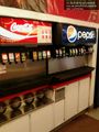
Tried to get GeoSquishy at the 76. They had stuff that was frozen and carbonated, but not both. @38.5615,-121.7701
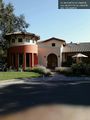
This is an interesting house... @38.5711,-121.7547
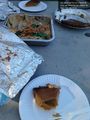
Our picnic! @38.5712,-121.7545
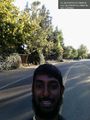
I'm here!
I did not know this bridge was here... @38.5699,-121.7614
Same with the lake. @38.5699,-121.7614
According to Daviswiki, these are supposed to have Satanic messages on them. @38.5657,-121.7634


Achievements
Chandru earned the Walk geohash Achievement
|
Chandru earned the Picnic achievement
|
Chandru earned the Drag-along achievement
|