Difference between revisions of "2012-09-30 -36 174"
imported>Greenslime m (fail) |
imported>FippeBot m (Location) |
||
| (One intermediate revision by one other user not shown) | |||
| Line 14: | Line 14: | ||
== Plans == | == Plans == | ||
| − | Well, check it out of course. Google maps showed the hash to be a large patch of white sand, probably reclaimed land as this area used to be Auckland's biggest oxidation ponds and has been replanted | + | Well, check it out of course. Google maps showed the hash to be a large patch of white sand, probably reclaimed land as this area used to be Auckland's biggest oxidation ponds and has been replanted and walking tracks constructed. |
== Expedition == | == Expedition == | ||
| Line 39: | Line 39: | ||
[[Category:Coordinates not reached]] | [[Category:Coordinates not reached]] | ||
[[Category:Not reached - No public access]] | [[Category:Not reached - No public access]] | ||
| + | {{location|NZ|AUK}} | ||
Latest revision as of 06:21, 13 August 2019
| Sun 30 Sep 2012 in -36,174: -36.9578945, 174.7687397 geohashing.info google osm bing/os kml crox |
Location
Estuary, Manukau Harbour, Auckland
Participants
Plans
Well, check it out of course. Google maps showed the hash to be a large patch of white sand, probably reclaimed land as this area used to be Auckland's biggest oxidation ponds and has been replanted and walking tracks constructed.
Expedition
After a bit of indecision, I decided to combine the hash with a running mission, sight seeing up a big nearby hill (Mangere Mountain), as well as a little geocaching.
So, the area still smells bad! From the satellite image, a fence was seen to extend around the hash area, even extending into the ocean, obviously a serious attempt to keep people out. I knew there was a high probability that this wouldnt work out, but the other activities lured me to the site.
Sure enough, after a short run to the site, I could see the fence, with some fancy Auckland Council signage - PLEASE LEAVE QUICKLY. The area is actually a bird sanctuary, in particular for the very endangered dotterel. No worries, I took a photo and sprinted out of there, to continue for another 16 kms and 4 caches. A productive day I thought.
Photos
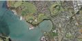
Satellite imagery
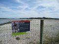
Please leave quickly, birds about
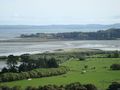
View of the hash point in the distance from nearby Mangere Mountain


