Difference between revisions of "2012-10-04 32 -116"
From Geohashing
imported>LucasBrown ([live picture] Geohash Droid map, zoomed out further, at the hashpoint [http://www.openstreetmap.org/?lat=32.81469513&lon=-116.92875248&zoom=16&layers=B000FTF @32.8147,-116.9288]) |
imported>FippeBot m (Location) |
||
| (3 intermediate revisions by 2 users not shown) | |||
| Line 1: | Line 1: | ||
| − | |||
| − | |||
| − | |||
| − | |||
| − | |||
| − | |||
| − | |||
| − | |||
| − | |||
| − | |||
{{meetup graticule | {{meetup graticule | ||
| lat=32 | | lat=32 | ||
| Line 15: | Line 5: | ||
}} | }} | ||
| − | |||
__NOTOC__ | __NOTOC__ | ||
== Location == | == Location == | ||
| − | + | Under a tree in an El Cajon neighborhood | |
== Participants == | == Participants == | ||
| − | + | [[User:LucasBrown|LucasBrown]] | |
| − | |||
| − | |||
| − | |||
| − | |||
| − | |||
| − | |||
| − | |||
== Tracklog == | == Tracklog == | ||
| − | + | https://maps.google.com/maps/ms?msa=0&msid=210599911669164566506.0004cb449b5c426608a3f | |
== Photos == | == Photos == | ||
| − | |||
| − | |||
| − | |||
<gallery perrow="5"> | <gallery perrow="5"> | ||
| − | |||
Image:2012-10-04_32_-116_16-12-27-358.jpg | Geohash Droid details page at the hashpoint [http://www.openstreetmap.org/?lat=32.81469513&lon=-116.92875248&zoom=16&layers=B000FTF @32.8147,-116.9288] | Image:2012-10-04_32_-116_16-12-27-358.jpg | Geohash Droid details page at the hashpoint [http://www.openstreetmap.org/?lat=32.81469513&lon=-116.92875248&zoom=16&layers=B000FTF @32.8147,-116.9288] | ||
| − | |||
Image:2012-10-04_32_-116_16-13-07-624.jpg | Geohash Droid map at the hashpoint [http://www.openstreetmap.org/?lat=32.81469513&lon=-116.92875248&zoom=16&layers=B000FTF @32.8147,-116.9288] | Image:2012-10-04_32_-116_16-13-07-624.jpg | Geohash Droid map at the hashpoint [http://www.openstreetmap.org/?lat=32.81469513&lon=-116.92875248&zoom=16&layers=B000FTF @32.8147,-116.9288] | ||
| − | |||
Image:2012-10-04_32_-116_16-14-12-727.jpg | Geohash Droid map, zoomed out further, at the hashpoint [http://www.openstreetmap.org/?lat=32.81469513&lon=-116.92875248&zoom=16&layers=B000FTF @32.8147,-116.9288] | Image:2012-10-04_32_-116_16-14-12-727.jpg | Geohash Droid map, zoomed out further, at the hashpoint [http://www.openstreetmap.org/?lat=32.81469513&lon=-116.92875248&zoom=16&layers=B000FTF @32.8147,-116.9288] | ||
</gallery> | </gallery> | ||
| Line 48: | Line 24: | ||
== Achievements == | == Achievements == | ||
{{#vardefine:ribbonwidth|800px}} | {{#vardefine:ribbonwidth|800px}} | ||
| − | + | {{Tron | latitude = 32 | longitude = -116 | date = 2012-10-04 | name = LucasBrown | tracklog = https://maps.google.com/maps/ms?msa=0&msid=210599911669164566506.0004cb449b5c426608a3f | possessive = his}} | |
| − | |||
| − | |||
| − | |||
| − | |||
| − | |||
| − | |||
| − | |||
| − | |||
| − | |||
| − | |||
[[Category:Expeditions]] | [[Category:Expeditions]] | ||
| − | |||
[[Category:Expeditions with photos]] | [[Category:Expeditions with photos]] | ||
| − | |||
| − | |||
| − | |||
| − | |||
| − | |||
[[Category:Coordinates reached]] | [[Category:Coordinates reached]] | ||
| − | + | {{location|US|CA|SD}} | |
| − | |||
| − | |||
| − | |||
| − | |||
| − | |||
| − | |||
| − | |||
| − | |||
| − | |||
| − | |||
| − | |||
| − | |||
| − | |||
| − | |||
| − | |||
| − | |||
| − | |||
Latest revision as of 06:23, 13 August 2019
| Thu 4 Oct 2012 in 32,-116: 32.8146961, -116.9287584 geohashing.info google osm bing/os kml crox |
Location
Under a tree in an El Cajon neighborhood
Participants
Tracklog
https://maps.google.com/maps/ms?msa=0&msid=210599911669164566506.0004cb449b5c426608a3f
Photos
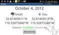
Geohash Droid details page at the hashpoint @32.8147,-116.9288
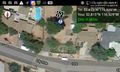
Geohash Droid map at the hashpoint @32.8147,-116.9288
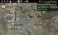
Geohash Droid map, zoomed out further, at the hashpoint @32.8147,-116.9288


Achievements
LucasBrown earned the Tron achievement
|