Difference between revisions of "2012-10-04 55 37"
imported>Vb (→Achievements) |
imported>Vb (→Photos) |
||
| Line 49: | Line 49: | ||
Image:2012-10-04_55_37_18-39-34-803.jpg | 14m - the hash is in the water [http://www.openstreetmap.org/?lat=55.82590000&lon=37.40200000&zoom=16&layers=B000FTF @55.8259,37.4020] | Image:2012-10-04_55_37_18-39-34-803.jpg | 14m - the hash is in the water [http://www.openstreetmap.org/?lat=55.82590000&lon=37.40200000&zoom=16&layers=B000FTF @55.8259,37.4020] | ||
| + | |||
| + | Image:2012-10-04 18.33.56.jpg | 12m to the hash - Geohashdroid turns green. [http://www.openstreetmap.org/?lat=55.82580000&lon=37.40200000&zoom=16&layers=B000FTF @55.8258,37.4020] | ||
Image:2012-10-04_55_37_18-37-46-583.jpg | 12m to the hash - Geohashdroid turns green. [http://www.openstreetmap.org/?lat=55.82580000&lon=37.40200000&zoom=16&layers=B000FTF @55.8258,37.4020] | Image:2012-10-04_55_37_18-37-46-583.jpg | 12m to the hash - Geohashdroid turns green. [http://www.openstreetmap.org/?lat=55.82580000&lon=37.40200000&zoom=16&layers=B000FTF @55.8258,37.4020] | ||
Revision as of 14:59, 5 October 2012
| Thu 4 Oct 2012 in 55,37: 55.8258864, 37.4022196 geohashing.info google osm bing/os kml crox |
Location
Small strait separating a small island on a Moskva river. Strogino again.
Participants
Plans
January First-of-May: Are you going for today's hash? I certainly won't ... but it is within the Ring Road, and from the satellite layer of Google Maps it looks like it's just barely reachable (i.e. right at the edge of the river).
vb: Strogino again. And looks like a fun place to go. Unfortunately I'm not in the city today. Possibly I'll be back not too late today but most probably not.
Expedition
Fortunately though vb was returning to the city almost exactly from the direction of the hash, so he made it. However he had to break his habit of no using other means than subway and walking to reach the hash - used a bus.
Tracklog
Photos
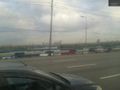
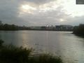
The hash is out there. 600m @55.8299,37.3944
120m to the hash @55.8327,37.3951
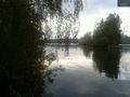
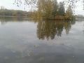
14m - the hash is in the water @55.8259,37.4020
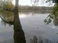
12m to the hash - Geohashdroid turns green. @55.8258,37.4020
12m to the hash - Geohashdroid turns green. @55.8258,37.4020
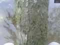
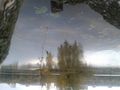
12m - climbed the tree to get closer@55.8258,37.4020
120m from the hash. @55.8260,37.4002
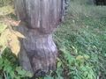
160m from the hash, work of beavers. @55.8260,37.4002


Achievements