Difference between revisions of "2012-10-06 42 -90"
imported>Swensonj (→Expedition: success!) |
|||
| (9 intermediate revisions by 3 users not shown) | |||
| Line 1: | Line 1: | ||
| − | |||
| − | |||
| − | |||
| − | |||
| − | |||
| − | |||
| − | |||
{{meetup graticule | {{meetup graticule | ||
| lat=42 | | lat=42 | ||
| Line 18: | Line 11: | ||
== Participants == | == Participants == | ||
| − | [[User:swensonj|SwensonJ]] | + | [[User:swensonj|SwensonJ]] and son |
== Plans == | == Plans == | ||
| − | [[User:swensonj|SwensonJ]] will pass through sometime, on the way to a Saturday XKCD [[2012-10-06_42_-91|meetup attempt]] in [[Cedar Rapids, Iowa|Cedar Rapids North]]. | + | [[User:swensonj|SwensonJ]] will pass through sometime, on the way to a Saturday XKCD [[2012-10-06_42_-91|meetup attempt]] in [[Cedar Rapids North, Iowa|Cedar Rapids North]]. |
== Expedition == | == Expedition == | ||
| − | + | We ([[User:swensonj|SwensonJ]] and son) left Platteville, Wisconsin, a little after 1 p.m., and started east towards Lancaster. It was a pleasant day for driving, with good fall colors. In downtown Lancaster, we had to detour around a parade route. It's the Harvest Festival today! We stopped to watch for a while; the son loaded up on free candy. We were pleasantly surprised to see the Dodgeville High School marching band come past -- their director is a friend of ours. | |
| − | + | We only watched the parade for a few minutes, then got back on the road. My son was very impressed with a giant cement block on which someone had painted a green smiley face. It was at the point where we turned onto County Highway A; a short time later we were stopped on the side of the road. | |
| − | + | ||
| + | A friendly man was out in the yard, playing ball with his dog. He told us that the hashpoint was in his neighbor's field, and that the neighbor wouldn't mind if we walked across the alfalfa for a bit. I also got to overhear his radio, and learned that the UW-Platteville football team had a big lead over UW-La Crosse: good news. The hash was easy to locate, on the border between alfalfa and corn stubble. We took each other's picture, then raced back to the car to head for the [[2012-10-06_42_-91|second part]] of our multihash. | ||
== Photos == | == Photos == | ||
| Line 34: | Line 28: | ||
Image:2012-##-## ## ## Alpha.jpg | Witty Comment | Image:2012-##-## ## ## Alpha.jpg | Witty Comment | ||
--> | --> | ||
| − | <gallery perrow=" | + | <gallery perrow="3"> |
| + | Image:2012-10-06 42 -90 Band.jpg | Dodgeville HS band passes the county courthouse in Lancaster, WI | ||
| + | Image:2012-10-06 42 -90 Smiley.jpg | Happy cement barrier | ||
| + | Image:2012-10-06 42 -90 Dog.jpg | Friendly dog plays ball | ||
| + | Image:2012-10-06 42 -90 Proof.jpg | GPS proof: we made it! | ||
| + | Image:2012-10-06 42 -90 Dad.jpg | [[User:swensonj|SwensonJ]] on the hash | ||
| + | Image:2012-10-06 42 -90 Kid.jpg | Son on the hash | ||
</gallery> | </gallery> | ||
== Achievements == | == Achievements == | ||
{{#vardefine:ribbonwidth|800px}} | {{#vardefine:ribbonwidth|800px}} | ||
| − | + | {{land geohash | |
| + | | latitude = 42 | ||
| + | | longitude = -90 | ||
| + | | date = 2012-10-06 | ||
| + | | name = SwensonJ | ||
| + | | image = 2012-10-06_42_-90 Proof.jpg | ||
| − | + | }} | |
| − | + | {{gratuitous ribbon | |
| − | |||
| − | + | | icon = Circusgeohash.GIF | |
| − | + | | latitude = 42 | |
| + | | longitude = -90 | ||
| + | | date = 2012-10-06 | ||
| + | | achievement = Hashdogball Achievement | ||
| + | | description = throwing a ball for a friendly dog on the way to | ||
| + | | name = SwensonJ | ||
| + | | image = 2012-10-06_42_-90 Dog.jpg | ||
| + | |||
| + | }} | ||
| + | {{Multihash | ||
| + | |||
| + | | latitude1 = 42 | ||
| + | | longitude1 = -90 | ||
| + | | latitude2 = 42 | ||
| + | | longitude2 = -91 | ||
| + | | date = 2012-10-06 | ||
| + | | name = SwensonJ | ||
| + | | image = 2012-10-06_42_-91 Together.jpg | ||
| + | |||
| + | }} | ||
| − | |||
[[Category:Expeditions]] | [[Category:Expeditions]] | ||
| − | |||
[[Category:Expeditions with photos]] | [[Category:Expeditions with photos]] | ||
| − | |||
| − | |||
| − | |||
| − | |||
| − | |||
[[Category:Coordinates reached]] | [[Category:Coordinates reached]] | ||
| − | + | {{location|US|WI|GA}} | |
| − | |||
| − | |||
| − | |||
| − | |||
| − | |||
| − | |||
| − | |||
| − | |||
| − | |||
| − | |||
| − | |||
| − | |||
| − | |||
| − | |||
| − | |||
| − | |||
| − | |||
Latest revision as of 17:00, 28 January 2021
| Sat 6 Oct 2012 in 42,-90: 42.8559654, -90.7559718 geohashing.info google osm bing/os kml crox |
Location
The edge of a field, off County Highway A, west of Lancaster, Wisconsin
Participants
SwensonJ and son
Plans
SwensonJ will pass through sometime, on the way to a Saturday XKCD meetup attempt in Cedar Rapids North.
Expedition
We (SwensonJ and son) left Platteville, Wisconsin, a little after 1 p.m., and started east towards Lancaster. It was a pleasant day for driving, with good fall colors. In downtown Lancaster, we had to detour around a parade route. It's the Harvest Festival today! We stopped to watch for a while; the son loaded up on free candy. We were pleasantly surprised to see the Dodgeville High School marching band come past -- their director is a friend of ours.
We only watched the parade for a few minutes, then got back on the road. My son was very impressed with a giant cement block on which someone had painted a green smiley face. It was at the point where we turned onto County Highway A; a short time later we were stopped on the side of the road.
A friendly man was out in the yard, playing ball with his dog. He told us that the hashpoint was in his neighbor's field, and that the neighbor wouldn't mind if we walked across the alfalfa for a bit. I also got to overhear his radio, and learned that the UW-Platteville football team had a big lead over UW-La Crosse: good news. The hash was easy to locate, on the border between alfalfa and corn stubble. We took each other's picture, then raced back to the car to head for the second part of our multihash.
Photos
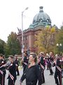
Dodgeville HS band passes the county courthouse in Lancaster, WI
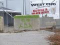
Happy cement barrier
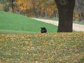
Friendly dog plays ball
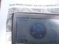
GPS proof: we made it!
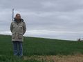
SwensonJ on the hash
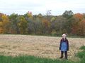
Son on the hash


Achievements
SwensonJ earned the Land geohash achievement
|
SwensonJ earned the Hashdogball Achievement
|
SwensonJ earned the Multihash Achievement
|