Difference between revisions of "2012-10-11 48 7"
From Geohashing
imported>Frizzy ([live picture] Picknick place [http://www.openstreetmap.org/?lat=48.13905069&lon=7.78580963&zoom=16&layers=B000FTF @48.1391,7.7858]) |
imported>FippeBot m (Location) |
||
| (11 intermediate revisions by one other user not shown) | |||
| Line 29: | Line 29: | ||
*Picknick! :-) -- [[User:Frizzy|Frizzy]] [http://www.openstreetmap.org/?lat=48.13904524&lon=7.78573193&zoom=16&layers=B000FTF @48.1390,7.7857] 11:49, 11 October 2012 (CEST) | *Picknick! :-) -- [[User:Frizzy|Frizzy]] [http://www.openstreetmap.org/?lat=48.13904524&lon=7.78573193&zoom=16&layers=B000FTF @48.1390,7.7857] 11:49, 11 October 2012 (CEST) | ||
| + | |||
| + | *Almost there! -- [[User:Frizzy|Frizzy]] [http://www.openstreetmap.org/?lat=48.18518557&lon=7.67999405&zoom=16&layers=B000FTF @48.1852,7.6800] 12:55, 11 October 2012 (CEST) | ||
| + | |||
| + | *Coordinates reached! :-) -- [[User:Frizzy|Frizzy]] [http://www.openstreetmap.org/?lat=48.18566539&lon=7.68008801&zoom=16&layers=B000FTF @48.1857,7.6801] 13:05, 11 October 2012 (CEST) | ||
== Photos == | == Photos == | ||
<gallery> | <gallery> | ||
| Line 36: | Line 40: | ||
Image:2012-10-11_48_7_11-52-07-761.jpg | Picknick place [http://www.openstreetmap.org/?lat=48.13905069&lon=7.78580963&zoom=16&layers=B000FTF @48.1391,7.7858] | Image:2012-10-11_48_7_11-52-07-761.jpg | Picknick place [http://www.openstreetmap.org/?lat=48.13905069&lon=7.78580963&zoom=16&layers=B000FTF @48.1391,7.7858] | ||
| + | |||
| + | Image:2012-10-11_48_7_12-09-26-118.jpg | Nice view on Riegel am Kaiserstuhl, where Elz is joining Dreisam. [http://www.openstreetmap.org/?lat=48.14697058&lon=7.75614347&zoom=16&layers=B000FTF @48.1470,7.7561] | ||
| + | |||
| + | Image:2012-10-11_48_7_12-56-40-498.jpg | Almost there! [http://www.openstreetmap.org/?lat=48.18514751&lon=7.67996815&zoom=16&layers=B000FTF @48.1851,7.6800] | ||
| + | |||
| + | Image:2012-10-11_48_7_12-58-12-129.jpg | Field of hash. [http://www.openstreetmap.org/?lat=48.18521503&lon=7.67997293&zoom=16&layers=B000FTF @48.1852,7.6800] | ||
| + | |||
| + | Image:2012-10-11_48_7_13-08-35-263.jpg | Stupid grin @ hashpoint | ||
| + | |||
| + | Image:2012-10-11_48_7_13-10-19-944.jpg | Reached! | ||
| + | |||
| + | Image:2012-10-11_48_7_13-13-16-536.jpg | Tasty apples near hashpoint ;-) [http://www.openstreetmap.org/?lat=48.18516038&lon=7.67990881&zoom=16&layers=B000FTF @48.1852,7.6799] | ||
| + | |||
| + | Image:2012-10-11_48_7_13-16-15-120.jpg | Muddy feet. [http://www.openstreetmap.org/?lat=48.18517496&lon=7.67988064&zoom=16&layers=B000FTF @48.1852,7.6799] | ||
</gallery> | </gallery> | ||
| Line 41: | Line 59: | ||
== Achievements == | == Achievements == | ||
| − | + | * Land geohash | |
| + | * bicycle geohash (~50 km in total) | ||
[[Category:Expeditions]] | [[Category:Expeditions]] | ||
| + | [[Category:Coordinates reached]] | ||
| + | {{location|DE|BW|EM}} | ||
Latest revision as of 06:28, 13 August 2019
| Thu 11 Oct 2012 in 48,7: 48.1856507, 7.6800425 geohashing.info google osm bing/os kml crox |
Location
On a field south of Weisweil
Participants
Plans
- Frizzy
- Damaged machines prevent me from work tomorrow, so I want to start the trip somewhen after breakfast by bike. Distance one way: ~ 25km --> something between one and two hours...
Expedition
- First stop for right navigation...Frizzy chose to turn left. -- Frizzy @48.0840,7.8623 11:05, 11 October 2012 (CEST)
- Picknick! :-) -- Frizzy @48.1390,7.7857 11:49, 11 October 2012 (CEST)
- Almost there! -- Frizzy @48.1852,7.6800 12:55, 11 October 2012 (CEST)
- Coordinates reached! :-) -- Frizzy @48.1857,7.6801 13:05, 11 October 2012 (CEST)
Photos
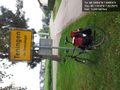
First station is reached! @48.1182,7.8226
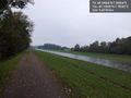
...and for about six kilometers the way looks like that... @48.1390,7.7858
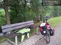
Picknick place @48.1391,7.7858
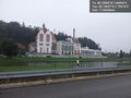
Nice view on Riegel am Kaiserstuhl, where Elz is joining Dreisam. @48.1470,7.7561
Almost there! @48.1851,7.6800
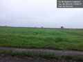
Field of hash. @48.1852,7.6800
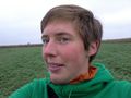
Stupid grin @ hashpoint

Reached!
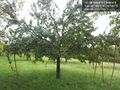
Tasty apples near hashpoint ;-) @48.1852,7.6799
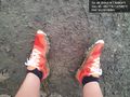
Muddy feet. @48.1852,7.6799


Achievements
* Land geohash
* bicycle geohash (~50 km in total)