Difference between revisions of "2012-10-18 32 -116"
From Geohashing
imported>LucasBrown (→Participants) |
imported>FippeBot m (Location) |
||
| (5 intermediate revisions by 2 users not shown) | |||
| Line 12: | Line 12: | ||
== Participants == | == Participants == | ||
[[User:LucasBrown|LucasBrown]] reached the hashpoint at 15:56 PDT. | [[User:LucasBrown|LucasBrown]] reached the hashpoint at 15:56 PDT. | ||
| − | |||
| − | |||
| − | |||
| − | |||
| − | |||
| − | |||
== Photos == | == Photos == | ||
| Line 29: | Line 23: | ||
== Achievements == | == Achievements == | ||
{{#vardefine:ribbonwidth|800px}} | {{#vardefine:ribbonwidth|800px}} | ||
| + | {{Consecutive geohash | count = 2 | latitude = 33 | longitude = -117 | date = 2012-10-17 | name = LucasBrown}} | ||
| − | |||
[[Category:Expeditions]] | [[Category:Expeditions]] | ||
[[Category:Expeditions with photos]] | [[Category:Expeditions with photos]] | ||
[[Category:Expedition without GPS]] | [[Category:Expedition without GPS]] | ||
[[Category:Coordinates reached]] | [[Category:Coordinates reached]] | ||
| + | {{location|US|CA|SD}} | ||
Latest revision as of 06:33, 13 August 2019
| Thu 18 Oct 2012 in 32,-116: 32.7913097, -116.9627045 geohashing.info google osm bing/os kml crox |
Location
Looks like it is in a parking lot at W. Palm and S. Magnolia in El Cajon. - Mathgeek
Participants
LucasBrown reached the hashpoint at 15:56 PDT.
Photos
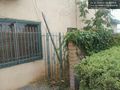
The hashpoint is just behind that gate. @32.7914,-116.9630
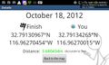
(LucasBrown) Geohash Droid details page at the hashpoint @32.7914,-116.9627
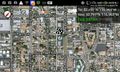
(LucasBrown) Map at the hashpoint @32.7914,-116.9627
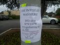
(LucasBrown) Sign deposited near the hashpoint @32.7916,-116.9630


Achievements
LucasBrown earned the Consecutive geohash achievement
|