Difference between revisions of "2012-10-19 32 -117"
imported>Mathgeek m (→Location) |
imported>FippeBot m (Location) |
||
| (24 intermediate revisions by 3 users not shown) | |||
| Line 1: | Line 1: | ||
| − | + | [[Image:Crest Canyon Entrance 2012-10-19 32 -117 15-18-36.jpg|Crest Canyon Park|thumb|left]] | |
| − | |||
| − | |||
| − | |||
| − | |||
| − | |||
| − | |||
| − | |||
| − | |||
| − | |||
{{meetup graticule | {{meetup graticule | ||
| lat=32 | | lat=32 | ||
| Line 15: | Line 6: | ||
}} | }} | ||
| − | |||
__NOTOC__ | __NOTOC__ | ||
== Location == | == Location == | ||
| − | |||
| − | Open space (hopefully) near Racetrack View | + | Open space (hopefully) near Racetrack View Dr. in Del Mar. - [[User:Mathgeek|Mathgeek]] 09:20, 19 October 2012 (PDT) |
| + | |||
| + | The hash point today falls in beautiful Crest Canyon Park in Del Mar. The point is nearest the entrance to the park on Racetrack View Dr. | ||
| + | |||
| + | Crest Canyon Park has been described as a local treasure. Originally intended as part of Torrey Pines State Preserve it was dropped at the time as a cost saving measure. The area was negatively impacted in the late 1960s by neighboring residential neighborhoods but activists encouraged the local governments to buy and save the land for public use. | ||
| + | |||
| + | There are two types of threatened plants. The first is the famous Torrey Pine, found only in this area and on Santa Rosa Island. The second is Dudleya brevifolia, a succulent that blooms in May and June with a small five pointed star shaped flower. | ||
| + | |||
| + | The best time to visit this area today will be around dusk when the animals will be most active. In addition to rabbits, the canyon is home to foxes and bobcats which you will most likely not see. The California quail, towhee and gnatcatcher are all residents of the canyon. | ||
| + | |||
| + | More information about this park: http://www.delmartimes.net/2011/01/27/opinion-secret-trails-of-crest-canyon/ | ||
== Participants == | == Participants == | ||
<!-- who attended: If you link to your wiki user name in this section, your expedition will be picked up by the various statistics generated for geohashing. You may use three tildes ~ as a shortcut to automatically insert the user signature of the account you are editing with. | <!-- who attended: If you link to your wiki user name in this section, your expedition will be picked up by the various statistics generated for geohashing. You may use three tildes ~ as a shortcut to automatically insert the user signature of the account you are editing with. | ||
--> | --> | ||
| + | |||
| + | * - [[User:Mathgeek|Mathgeek]] | ||
| + | * [[User:Scerruti|Stephen Cerruti]], A', D* | ||
| + | * - [[User:LucasBrown|LucasBrown]] reached the hashpoint at about 17:45 PDT. | ||
== Plans == | == Plans == | ||
| − | + | * - Maybe after work today - [[User:Mathgeek|Mathgeek]] 09:27, 19 October 2012 (PDT) | |
| + | * Head down after school with the boys [[User:Scerruti|Stephen Cerruti]] 14:53, 19 October 2012 (EDT) | ||
| + | |||
| + | == Nearby Geocaches == | ||
| + | * http://coord.info/GC2MHJF | ||
| + | * http://coord.info/GC2QQKM | ||
== Expedition == | == Expedition == | ||
| − | |||
| − | == | + | *After picking up D* from school we drove down from Oceanside. Street parking was readily available and we moved quickly to the hash point. Well I moved quickly, my sons decided that they would rather crawl through the bushes. We made it to the hash point, tip toeing carefully once we left the main trail to minimize damage. We did pick up a lot of trash at the hash point so I consider it a wash. We then hiked up the hillside to find a geocache and to shoot some video about Torrey pines. Finally we hiked up the canyon looking for a gnatcatcher. While we were up in the canyon discussing the difference between male and female Torrey pines, [[User:Mathgeek|Mathgeek]] snuck in behind us without us noticing. All in all it was a great hike in one of those amazing spots that remind you how great it is to live in San Diego. -- [[User:Scerruti|Stephen Cerruti]] [http://www.openstreetmap.org/?lat=32.96255100&lon=-117.25474614&zoom=16&layers=B000FTF @32.9626,-117.2547] 18:23, 19 October 2012 (EDT) |
| − | + | ||
| + | *I made it... I can't believe twice in one week. -- [[User:Mathgeek|Mathgeek]] [http://www.openstreetmap.org/?lat=32.96261594&lon=-117.25472499&zoom=16&layers=B000FTF @32.9626,-117.2547] 16:33, 19 October 2012 (PDT) | ||
== Photos == | == Photos == | ||
| − | |||
| − | |||
| − | |||
<gallery perrow="5"> | <gallery perrow="5"> | ||
| + | |||
| + | Image:Map Reading 2012-10-19 32 -117 15-28-35.jpg | Reading the map | ||
| + | |||
| + | Image:2012-10-19_32_-117_15-30-46-132.jpg | Stupid grins [http://www.openstreetmap.org/?lat=32.96245863&lon=-117.25481026&zoom=16&layers=B000FTF @32.9625,-117.2548] | ||
| + | |||
| + | Image:Up the hill 2012-10-19 32 -117 15-35-54.jpg | The kids ran off again | ||
| + | |||
| + | Image:2012-10-19_32_-117_16-31-17-787.jpg | Nice view today... [http://www.openstreetmap.org/?lat=32.96262627&lon=-117.25471076&zoom=16&layers=B000FTF @32.9626,-117.2547] | ||
| + | |||
| + | Image:2012-10-19_32_-117_16-32-22-525.jpg | Obligatory half goofy smile... [http://www.openstreetmap.org/?lat=32.96263204&lon=-117.25473302&zoom=16&layers=B000FTF @32.9626,-117.2547] | ||
| + | |||
| + | Image:2012-10-19_32_-117_17-45-49-302.jpg | ([[User:LucasBrown|LucasBrown]]) Geohash Droid details page at the hashpoint [http://www.openstreetmap.org/?lat=32.96264461&lon=-117.25473759&zoom=16&layers=B000FTF @32.9626,-117.2547] | ||
| + | |||
| + | Image:2012-10-19_32_-117_17-46-18-774.jpg | ([[User:LucasBrown|LucasBrown]]) Map at the hashpoint [http://www.openstreetmap.org/?lat=32.96264266&lon=-117.25473757&zoom=16&layers=B000FTF @32.9626,-117.2547] | ||
| + | |||
| + | Image:2012-10-19_32_-117_17-46-55-821.jpg | The hashpoint is at thia bush. [http://www.openstreetmap.org/?lat=32.96260000&lon=-117.25500000&zoom=16&layers=B000FTF @32.9626,-117.2550] | ||
| + | |||
| + | Image:2012-10-19_32_-117_17-47-31-466.jpg | View of the Del Mar fairgrounds from the hashpoint [http://www.openstreetmap.org/?lat=32.96260000&lon=-117.25500000&zoom=16&layers=B000FTF @32.9626,-117.2550] | ||
</gallery> | </gallery> | ||
| + | == Video == | ||
| + | |||
| + | In my attempt to bring learning into our geohashing outings, the boys recorded this video about the Torrey pine near the hashpoint. | ||
| + | |||
| + | [[Image:Video Thumb 2012-10-19 32 -117.jpg | link=http://youtu.be/F2iCeG4HVOk | About the Torrey Pine]] | ||
| + | |||
| + | [http://youtu.be/F2iCeG4HVOk About the Torrey Pine] | ||
== Achievements == | == Achievements == | ||
{{#vardefine:ribbonwidth|800px}} | {{#vardefine:ribbonwidth|800px}} | ||
<!-- Add any achievement ribbons you earned below, or remove this section --> | <!-- Add any achievement ribbons you earned below, or remove this section --> | ||
| + | {{Consecutive geohash | count = 3 | latitude = 33 | longitude = -117 | date = 2012-10-17 | name = LucasBrown}} | ||
| + | |||
| − | |||
| − | |||
| − | |||
| − | |||
| − | |||
| − | |||
| − | |||
| − | |||
| − | |||
| − | |||
| − | |||
[[Category:Expeditions]] | [[Category:Expeditions]] | ||
| − | |||
[[Category:Expeditions with photos]] | [[Category:Expeditions with photos]] | ||
[[Category:Expeditions with videos]] | [[Category:Expeditions with videos]] | ||
| − | |||
| − | |||
| − | |||
| − | |||
[[Category:Coordinates reached]] | [[Category:Coordinates reached]] | ||
| − | + | {{location|US|CA|SD}} | |
| − | |||
| − | |||
| − | |||
| − | |||
| − | |||
| − | |||
| − | |||
| − | |||
| − | |||
| − | |||
| − | |||
| − | |||
| − | |||
| − | |||
| − | |||
| − | |||
| − | |||
Latest revision as of 06:34, 13 August 2019

| Fri 19 Oct 2012 in 32,-117: 32.9626230, -117.2547169 geohashing.info google osm bing/os kml crox |
Location
Open space (hopefully) near Racetrack View Dr. in Del Mar. - Mathgeek 09:20, 19 October 2012 (PDT)
The hash point today falls in beautiful Crest Canyon Park in Del Mar. The point is nearest the entrance to the park on Racetrack View Dr.
Crest Canyon Park has been described as a local treasure. Originally intended as part of Torrey Pines State Preserve it was dropped at the time as a cost saving measure. The area was negatively impacted in the late 1960s by neighboring residential neighborhoods but activists encouraged the local governments to buy and save the land for public use.
There are two types of threatened plants. The first is the famous Torrey Pine, found only in this area and on Santa Rosa Island. The second is Dudleya brevifolia, a succulent that blooms in May and June with a small five pointed star shaped flower.
The best time to visit this area today will be around dusk when the animals will be most active. In addition to rabbits, the canyon is home to foxes and bobcats which you will most likely not see. The California quail, towhee and gnatcatcher are all residents of the canyon.
More information about this park: http://www.delmartimes.net/2011/01/27/opinion-secret-trails-of-crest-canyon/
Participants
- - Mathgeek
- Stephen Cerruti, A', D*
- - LucasBrown reached the hashpoint at about 17:45 PDT.
Plans
- - Maybe after work today - Mathgeek 09:27, 19 October 2012 (PDT)
- Head down after school with the boys Stephen Cerruti 14:53, 19 October 2012 (EDT)
Nearby Geocaches
Expedition
- After picking up D* from school we drove down from Oceanside. Street parking was readily available and we moved quickly to the hash point. Well I moved quickly, my sons decided that they would rather crawl through the bushes. We made it to the hash point, tip toeing carefully once we left the main trail to minimize damage. We did pick up a lot of trash at the hash point so I consider it a wash. We then hiked up the hillside to find a geocache and to shoot some video about Torrey pines. Finally we hiked up the canyon looking for a gnatcatcher. While we were up in the canyon discussing the difference between male and female Torrey pines, Mathgeek snuck in behind us without us noticing. All in all it was a great hike in one of those amazing spots that remind you how great it is to live in San Diego. -- Stephen Cerruti @32.9626,-117.2547 18:23, 19 October 2012 (EDT)
- I made it... I can't believe twice in one week. -- Mathgeek @32.9626,-117.2547 16:33, 19 October 2012 (PDT)
Photos
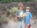
Reading the map

Stupid grins @32.9625,-117.2548
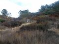
The kids ran off again
Nice view today... @32.9626,-117.2547

Obligatory half goofy smile... @32.9626,-117.2547

(LucasBrown) Geohash Droid details page at the hashpoint @32.9626,-117.2547
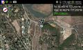
(LucasBrown) Map at the hashpoint @32.9626,-117.2547
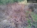
The hashpoint is at thia bush. @32.9626,-117.2550
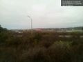
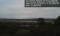
View of the Del Mar fairgrounds from the hashpoint @32.9626,-117.2550


Video
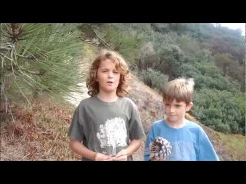
In my attempt to bring learning into our geohashing outings, the boys recorded this video about the Torrey pine near the hashpoint.
Achievements
LucasBrown earned the Consecutive geohash achievement
|