Difference between revisions of "2012-10-21 52 0"
imported>PaintedJaguar m (Typos/clarification) |
imported>PaintedJaguar (Added photos) |
||
| Line 1: | Line 1: | ||
| − | |||
| − | |||
| − | |||
| − | |||
| − | |||
| − | |||
| − | |||
| − | |||
| − | |||
{{meetup graticule | {{meetup graticule | ||
| lat=52 | | lat=52 | ||
| Line 31: | Line 22: | ||
== Tracklog == | == Tracklog == | ||
| − | http://en.wikiloc.com/wikiloc/view.do?id=3510573 | + | http://en.wikiloc.com/wikiloc/view.do?id=3510573 (shows the bus journey from Cambridge, walk to the hashpoint, and the walk into Haverhill town centre). |
== Photos == | == Photos == | ||
| − | |||
| − | |||
| − | |||
| − | |||
<gallery perrow="5"> | <gallery perrow="5"> | ||
| + | Image:2012-10-21_52_0_publictransport.JPG|Proof of public transport achievement | ||
| + | Image:2012-10-21_52_0_gps.JPG|At the hashpoint | ||
| + | Image:2012-10-21_52_0_grin.JPG|Silly grins | ||
| + | Image:2012-10-21_52_0_marker.JPG|XKCD marker | ||
| + | Image:2012-10-21_52_0_roadsign.JPG|Teasel Close road sign | ||
| + | Image:2012-10-21_52_0_view.JPG|View from the hashpoint | ||
| + | Image:2012-10-21_52_0_cat.JPG|Hashcat | ||
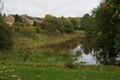
| + | Image:2012-10-21_52_0_floodsigns.JPG|Entering the floodwater storage area... | ||
| + | Image:2012-10-21_52_0_floodstoragearea.JPG|...which wasn't in use at the moment | ||
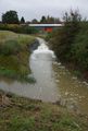
| + | Image:2012-10-21_52_0_river.JPG|Fast-flowing river | ||
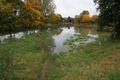
| + | Image:2012-10-21_52_0_flood1.JPG|Flooded land | ||
| + | Image:2012-10-21_52_0_flood2.JPG|Flooded land and nearby houses | ||
</gallery> | </gallery> | ||
| Line 48: | Line 47: | ||
| date = 2012-10-21 | | date = 2012-10-21 | ||
| name = PaintedJaguar | | name = PaintedJaguar | ||
| − | |||
}} | }} | ||
{{Public transport geohash | {{Public transport geohash | ||
| Line 56: | Line 54: | ||
| busline = the number 13 bus from Cambridge to Haverhill | | busline = the number 13 bus from Cambridge to Haverhill | ||
| name = PaintedJaguar | | name = PaintedJaguar | ||
| − | | image = | + | | image = 2012-10-21_52_0_publictransport.JPG |
}} | }} | ||
| Line 63: | Line 61: | ||
[[Category:Expeditions]] | [[Category:Expeditions]] | ||
| + | [[Category:Expeditions with photos]] | ||
[[Category:Coordinates reached]] | [[Category:Coordinates reached]] | ||
Revision as of 22:40, 21 October 2012
| Sun 21 Oct 2012 in 52,0: 52.0883282, 0.4197975 geohashing.info google osm bing/os kml crox |
Location
At the end of Teasel Close in Haverhill.
Participants
- PaintedJaguar
- MrsPaintedJaguar
Plans
PaintedJaguar aims to travel by bus from Cambridge, catching the number 13 (timetable) from Addenbrooke's Hospital at 11:22am, arriving in Haverhill just before 12:00. There appears to be a stop opposite the northern end of Park Road, a few minutes walk from the hashpoint.
Expedition
This was a pretty simple expedition. The bus arrived at Addenbrooke's Hospital exactly on time, and took us to Haverhill with only a few detours through some picturesque villages on the way. After leaving the bus in Haverhill, we made the short walk up Park Road and Teasel Close, and found the hashpoint next to a tree. The tree was rather large, and the boundary between the footpath and somebody's back garden was directly underneath it, so we couldn't tell beforehand from Google's satellite photos if the hashpoint was on public land or not, but it turned out that it was easily accessible. We took some photos, wrote a message in chalk on the path, and then headed off.
We decided to walk into the town centre of Haverhill, which was probably a more interesting walk than reaching the hashpoint. First we encounted a large (clearly man-made area) of land next to a river that was designed to trap and hold floodwater, to prevent it all reaching the town at once (more background info here.) We continued along a path that followed the river into the town, and you could really see why the flood defences were needed - even after not very much rain in the last few days, there were a couple of areas where the river was flooded, which looked rather close to nearby housing for my liking! The river was flowing rather forcefully through the town centre, and, as we later found out here, the river channel through the town is actually considered more of an eyesore, barely getting above a small trickle.
Tracklog
http://en.wikiloc.com/wikiloc/view.do?id=3510573 (shows the bus journey from Cambridge, walk to the hashpoint, and the walk into Haverhill town centre).
Photos
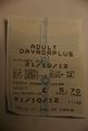
Proof of public transport achievement
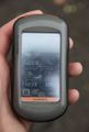
At the hashpoint

Silly grins
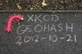
XKCD marker
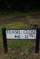
Teasel Close road sign
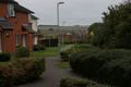
View from the hashpoint
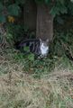
Hashcat
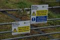
Entering the floodwater storage area...
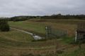
...which wasn't in use at the moment
Fast-flowing river
Flooded land
Flooded land and nearby houses


Achievements
PaintedJaguar earned the Land geohash achievement
|
PaintedJaguar earned the Public transport geohash achievement
|