Difference between revisions of "2012-10-22 28 -81"
imported>Canadaman123 (→Photos) |
imported>FippeBot m (Location) |
||
| (6 intermediate revisions by 3 users not shown) | |||
| Line 5: | Line 5: | ||
}} | }} | ||
| − | + | ||
__NOTOC__ | __NOTOC__ | ||
== Location == | == Location == | ||
| − | + | ||
By Google Maps surveillance, this hash appeared to be in an open public field not far off a side road in a residential area. However, upon arrival, that open field turned out to be fairly wet and marshy. The hash point was practically right on the outside corner of a fenced lot. Also, there was construction in the area. | By Google Maps surveillance, this hash appeared to be in an open public field not far off a side road in a residential area. However, upon arrival, that open field turned out to be fairly wet and marshy. The hash point was practically right on the outside corner of a fenced lot. Also, there was construction in the area. | ||
== Participants == | == Participants == | ||
| − | + | ||
| − | + | * [[User:Canadaman123]] | |
| + | * Tim | ||
| + | |||
Myself and a good friend of mine named Tim. We used to work together, and this hash was directly between our now separate places of employment. | Myself and a good friend of mine named Tim. We used to work together, and this hash was directly between our now separate places of employment. | ||
== Plans == | == Plans == | ||
| − | + | ||
A quick Google Chat to check Tim's availability was all that was needed. I used an app on my Android phone to get the location and opened it in Google Maps for navigation to the street adjacent to the hash. I planned on switching back to the app to bear in on the exact spot. | A quick Google Chat to check Tim's availability was all that was needed. I used an app on my Android phone to get the location and opened it in Google Maps for navigation to the street adjacent to the hash. I planned on switching back to the app to bear in on the exact spot. | ||
== Expedition == | == Expedition == | ||
| − | + | ||
The drive to the location was uneventful, though I was concerned about traffic at noon. After pulling off to the side of the road at the appropriate spot, I decided that a sign was needed to mark the occasion. I found a nice impressionistic water color painting my 4 year old son had left in the car the week before, and quickly penned in the date, the coordinates, "The Internet Was Here", and a quick sketch of hat man. | The drive to the location was uneventful, though I was concerned about traffic at noon. After pulling off to the side of the road at the appropriate spot, I decided that a sign was needed to mark the occasion. I found a nice impressionistic water color painting my 4 year old son had left in the car the week before, and quickly penned in the date, the coordinates, "The Internet Was Here", and a quick sketch of hat man. | ||
I waited about 5 minutes before Tim arrived. We both quickly noticed that the exact hash point was within sight, but completely surrounded by marshy swamp (welcome to Florida). Not quickly daunted, we picked our way around the deepest waters and found a relatively dry path until we were within 2 meters of the coordinates. Keep in mind, we were on our lunch breaks, wearing dress pants, collared shirts, and the kind of shoes a developer wears when trying to fit in with business types at the corporate office. | I waited about 5 minutes before Tim arrived. We both quickly noticed that the exact hash point was within sight, but completely surrounded by marshy swamp (welcome to Florida). Not quickly daunted, we picked our way around the deepest waters and found a relatively dry path until we were within 2 meters of the coordinates. Keep in mind, we were on our lunch breaks, wearing dress pants, collared shirts, and the kind of shoes a developer wears when trying to fit in with business types at the corporate office. | ||
| − | That said, we immediately began rummaging around the surrounding swamp for a suitable log with which we could cross the remaining puddle between ourselves and our goal. We managed to find three, all of which were infested with large blood-red ants. Being intelligent men, we laid a protective layer of palm fronds beneath the logs to avoid splash-ups and provide additional stability. When finished, our "Bridge to 28.671, -81.195" looked a lot like a " | + | That said, we immediately began rummaging around the surrounding swamp for a suitable log with which we could cross the remaining puddle between ourselves and our goal. We managed to find three, all of which were infested with large blood-red ants. Being intelligent men, we laid a protective layer of palm fronds beneath the logs to avoid splash-ups and provide additional stability. When finished, our "Bridge to 28.671, -81.195" looked a lot like a "Bridge to Nowhere", with the exception that the destination was much more geeky. |
Tim was the first to bravely cross the channel, and I followed after. The hash point was located between two trees on a small, muddy island. We set up our sign, took some photos, and balanced our way out of there. | Tim was the first to bravely cross the channel, and I followed after. The hash point was located between two trees on a small, muddy island. We set up our sign, took some photos, and balanced our way out of there. | ||
| Line 38: | Line 40: | ||
== Photos == | == Photos == | ||
| − | + | ||
| − | |||
| − | |||
<gallery perrow="5"> | <gallery perrow="5"> | ||
| − | + | Image:Phone-Map.JPG | We are the blue dot. Hash is the checkered flag. 1.8 meters away. | |
| − | + | Image: Note-From-Internet.JPG | Note from the internet. | |
| − | + | Image: Nate-And-Tim.JPG | The Hashers | |
| + | Image: Tim-Crossing.jpg | Tim crossing the bridge to the hashpoint | ||
| + | Image: The-Bridge.jpg | The Bridge to 28.671, -81.195 | ||
</gallery> | </gallery> | ||
| Line 51: | Line 53: | ||
<!-- Add any achievement ribbons you earned below, or remove this section --> | <!-- Add any achievement ribbons you earned below, or remove this section --> | ||
| + | * Land Geohash | ||
| − | + | I am claiming "There might be alligators!" Achievement, but not as a consolation prize. We did reach the hash point despite the threat of swamp things. | |
| − | + | ||
| − | + | {{There might be alligators! | |
| + | | latitude = 28 | ||
| + | | longitude = -81 | ||
| + | | date = 2012-10-22 | ||
| + | }} | ||
| − | |||
| − | |||
| − | |||
| − | |||
| − | |||
[[Category:Expeditions]] | [[Category:Expeditions]] | ||
| − | |||
[[Category:Expeditions with photos]] | [[Category:Expeditions with photos]] | ||
| − | |||
| − | |||
| − | |||
| − | |||
| − | |||
[[Category:Coordinates reached]] | [[Category:Coordinates reached]] | ||
| − | + | {{location|US|FL|SE}} | |
| − | |||
| − | |||
| − | |||
| − | |||
| − | |||
| − | |||
| − | |||
| − | |||
| − | |||
| − | |||
| − | |||
| − | |||
| − | |||
| − | |||
| − | |||
| − | |||
| − | |||
Latest revision as of 05:18, 6 August 2019
| Mon 22 Oct 2012 in 28,-81: 28.6712662, -81.1950194 geohashing.info google osm bing/os kml crox |
Location
By Google Maps surveillance, this hash appeared to be in an open public field not far off a side road in a residential area. However, upon arrival, that open field turned out to be fairly wet and marshy. The hash point was practically right on the outside corner of a fenced lot. Also, there was construction in the area.
Participants
Myself and a good friend of mine named Tim. We used to work together, and this hash was directly between our now separate places of employment.
Plans
A quick Google Chat to check Tim's availability was all that was needed. I used an app on my Android phone to get the location and opened it in Google Maps for navigation to the street adjacent to the hash. I planned on switching back to the app to bear in on the exact spot.
Expedition
The drive to the location was uneventful, though I was concerned about traffic at noon. After pulling off to the side of the road at the appropriate spot, I decided that a sign was needed to mark the occasion. I found a nice impressionistic water color painting my 4 year old son had left in the car the week before, and quickly penned in the date, the coordinates, "The Internet Was Here", and a quick sketch of hat man.
I waited about 5 minutes before Tim arrived. We both quickly noticed that the exact hash point was within sight, but completely surrounded by marshy swamp (welcome to Florida). Not quickly daunted, we picked our way around the deepest waters and found a relatively dry path until we were within 2 meters of the coordinates. Keep in mind, we were on our lunch breaks, wearing dress pants, collared shirts, and the kind of shoes a developer wears when trying to fit in with business types at the corporate office.
That said, we immediately began rummaging around the surrounding swamp for a suitable log with which we could cross the remaining puddle between ourselves and our goal. We managed to find three, all of which were infested with large blood-red ants. Being intelligent men, we laid a protective layer of palm fronds beneath the logs to avoid splash-ups and provide additional stability. When finished, our "Bridge to 28.671, -81.195" looked a lot like a "Bridge to Nowhere", with the exception that the destination was much more geeky.
Tim was the first to bravely cross the channel, and I followed after. The hash point was located between two trees on a small, muddy island. We set up our sign, took some photos, and balanced our way out of there.
Lunch at Tijuana Flats rounded off the expedition nicely.
Mission Success!
Tracklog
Photos
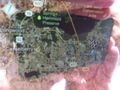
We are the blue dot. Hash is the checkered flag. 1.8 meters away.
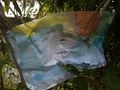
Note from the internet.
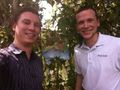
The Hashers
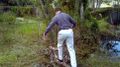
Tim crossing the bridge to the hashpoint
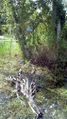
The Bridge to 28.671, -81.195


Achievements
- Land Geohash
I am claiming "There might be alligators!" Achievement, but not as a consolation prize. We did reach the hash point despite the threat of swamp things.
This user earned the There might be alligators! consolation prize
|