Difference between revisions of "2012-10-23 56 -3"
imported>Shane |
imported>FippeBot m (Location) |
||
| (5 intermediate revisions by 2 users not shown) | |||
| Line 1: | Line 1: | ||
| − | |||
| − | |||
| − | |||
| − | |||
{{meetup graticule | {{meetup graticule | ||
| lat=56 | | lat=56 | ||
| Line 31: | Line 27: | ||
At this point, Ewan decided that he wasn't going to enter the field with horses and sheep in it, so Shane went on alone. A small drainage ditch required a small detour and the co-ordinates were then easily reached. This was an insignificant flat patch of ground, but with stunning views all around (which my camera cannot do justice). | At this point, Ewan decided that he wasn't going to enter the field with horses and sheep in it, so Shane went on alone. A small drainage ditch required a small detour and the co-ordinates were then easily reached. This was an insignificant flat patch of ground, but with stunning views all around (which my camera cannot do justice). | ||
| − | + | I spelt out some letters for the camera, and then had an earworm of a different four-letter spelling for the rest of the day. | |
| − | The main road took us in to Comrie, from where we headed up the Glen Artney Road before returning over the | + | Once the photography was complete, we continued West along the railway alignment. This soon changed from track to path, and then brought us to a rickety looking bridge. We declined to cross this and instead found a path North to the main road. |
| + | |||
| + | The main road took us in to Comrie, from where we headed up the Glen Artney Road before returning over the col to Braco and Dunblane for the train home. | ||
== Photos == | == Photos == | ||
<!-- Insert pictures between the gallery tags using the following format: | <!-- Insert pictures between the gallery tags using the following format: | ||
Image:2012-##-## ## ## Alpha.jpg | Witty Comment --> | Image:2012-##-## ## ## Alpha.jpg | Witty Comment --> | ||
<gallery perrow="6"> | <gallery perrow="6"> | ||
| + | Image:2012-10-23_56_-3_xkcd.jpg | XKCD on the spot | ||
Image:2012-10-23_56_-3_the_field.jpg | Tales of the River Bank | Image:2012-10-23_56_-3_the_field.jpg | Tales of the River Bank | ||
Image:2012-10-23_56_-3_the_spot.jpg | ???? marks the spot | Image:2012-10-23_56_-3_the_spot.jpg | ???? marks the spot | ||
| Line 52: | Line 51: | ||
| name = Ewan | | name = Ewan | ||
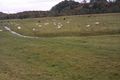
| reason = there were sheep and horses in the field | | reason = there were sheep and horses in the field | ||
| + | | image = 2012-10-23_56_-3_beasts.jpg | ||
}} | }} | ||
| − | + | ||
| − | |||
[[Category:Expeditions]] | [[Category:Expeditions]] | ||
| + | [[Category:Expeditions with photos]] | ||
[[Category:Coordinates reached]] | [[Category:Coordinates reached]] | ||
| + | {{location|GB|SCT|PKN}} | ||
Latest revision as of 06:38, 13 August 2019
| Tue 23 Oct 2012 in 56,-3: 56.3713139, -3.9250776 geohashing.info google osm bing/os kml crox |
Location
The side of a river near Crieff.
Participants
- Shane
- Ewan
Plans
Shane hopes to divert Ewan to the location. We are likely to be cycling in the area anyway.
Expedition
The weather in Edinburgh was foggy and predicted to stay that way all day. Fortunately conditions further West were forecast to be better, though still cloudy. The cloud remained all day, but we escaped mist and fog, though we frequently saw wisps on the hills, adding to the views.
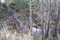
As planned we got the train to Dunblane and cycled via Braco and over the col past Ben Clach. The autumn colours were especially vivid on the Glascorrie Road and on the private road past Strowan House. We crossed the river and then left the road to join the line of the dismantled railway along the North side of the River Earn. Once we'd gone far enough we got off the bikes.
At this point, Ewan decided that he wasn't going to enter the field with horses and sheep in it, so Shane went on alone. A small drainage ditch required a small detour and the co-ordinates were then easily reached. This was an insignificant flat patch of ground, but with stunning views all around (which my camera cannot do justice).
I spelt out some letters for the camera, and then had an earworm of a different four-letter spelling for the rest of the day.
Once the photography was complete, we continued West along the railway alignment. This soon changed from track to path, and then brought us to a rickety looking bridge. We declined to cross this and instead found a path North to the main road.
The main road took us in to Comrie, from where we headed up the Glen Artney Road before returning over the col to Braco and Dunblane for the train home.
Photos
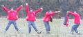
XKCD on the spot
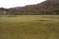
Tales of the River Bank
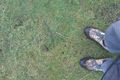
???? marks the spot
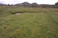
Wish you were here
Wouldn't you be frightened?
Cycle traffic calming


Achievements
Shane earned the Land geohash achievement
|
Ewan earned the Prize poultry Consolation Prize
|