Difference between revisions of "2012-10-30 47 8"
imported>Foehammer (→Photos) |
imported>FippeBot m (Location) |
||
| (6 intermediate revisions by 2 users not shown) | |||
| Line 1: | Line 1: | ||
<!-- If you did not specify these parameters in the template, please substitute appropriate values for IMAGE, LAT, LON, and DATE (YYYY-MM-DD format) | <!-- If you did not specify these parameters in the template, please substitute appropriate values for IMAGE, LAT, LON, and DATE (YYYY-MM-DD format) | ||
| − | [[Image:{{{image| | + | [[Image:{{{image|2012-10-30-47-8-stupidgrin.jpg}}}|thumb|left]] |
Remove this section if you don't want an image at the top (left) of your report. You should remove the "Image:" or "File:" | Remove this section if you don't want an image at the top (left) of your report. You should remove the "Image:" or "File:" | ||
| Line 14: | Line 14: | ||
}} | }} | ||
| − | + | ||
__NOTOC__ | __NOTOC__ | ||
== Location == | == Location == | ||
| − | + | ||
At the edge of a wood, only 900m away from [[User:Foehammer|Foehammer]]s home | At the edge of a wood, only 900m away from [[User:Foehammer|Foehammer]]s home | ||
== Participants == | == Participants == | ||
| − | + | ||
| − | |||
* [[User:Foehammer|Foehammer]] | * [[User:Foehammer|Foehammer]] | ||
== Plans == | == Plans == | ||
| − | + | ||
Having lots of free time at the moment, I plan on reaching the hash at around 1430. Since the closest road to the hash still is 400m away and there's probably 15cm of snow right now, it'll be quite some walk out there. | Having lots of free time at the moment, I plan on reaching the hash at around 1430. Since the closest road to the hash still is 400m away and there's probably 15cm of snow right now, it'll be quite some walk out there. | ||
== Expedition == | == Expedition == | ||
| − | + | ||
What a surprise! Another geohash closer than one kilometre from my home, even closer than [[2012-05-04 47 8]]! Of course I had to make it to this one. | What a surprise! Another geohash closer than one kilometre from my home, even closer than [[2012-05-04 47 8]]! Of course I had to make it to this one. | ||
| + | |||
As my plans never turn out the way I intend them to, I was busy until 1450 and then go convinced to go for a walk with my mom and our dog. Shortly after we started, I remembered the hash - luckily, I never leave the house without my phone so Geohash Droid was with me and we were even walking in the right direction. | As my plans never turn out the way I intend them to, I was busy until 1450 and then go convinced to go for a walk with my mom and our dog. Shortly after we started, I remembered the hash - luckily, I never leave the house without my phone so Geohash Droid was with me and we were even walking in the right direction. | ||
I intended to make this a Tron Achievement hash, but because of the unconcious start, I probably messed that one up, the trail is in the gallery. | I intended to make this a Tron Achievement hash, but because of the unconcious start, I probably messed that one up, the trail is in the gallery. | ||
| + | |||
Halfway to the hash, my mom decided to go back home, another solo hash for me. | Halfway to the hash, my mom decided to go back home, another solo hash for me. | ||
| Line 46: | Line 47: | ||
== Photos == | == Photos == | ||
| − | + | ||
| − | |||
| − | |||
<gallery perrow="5"> | <gallery perrow="5"> | ||
Image:2012-10-30-47-8-leaves.jpg | some leaves, some snow and the road | Image:2012-10-30-47-8-leaves.jpg | some leaves, some snow and the road | ||
| Line 64: | Line 63: | ||
Image:2012-10-30-47-8-alpscropped.png | The alps with Titlis in the middle | Image:2012-10-30-47-8-alpscropped.png | The alps with Titlis in the middle | ||
Image:2012-10-30-47-8-Trail.png | the journey I took - first/last junction screwes the Tron achievement | Image:2012-10-30-47-8-Trail.png | the journey I took - first/last junction screwes the Tron achievement | ||
| + | Image:2012-10-30-47-8-distance.png | the distance and heightdifference I travelled | ||
</gallery> | </gallery> | ||
== Achievements == | == Achievements == | ||
{{#vardefine:ribbonwidth|800px}} | {{#vardefine:ribbonwidth|800px}} | ||
| − | |||
| + | {{land geohash | ||
| − | + | | latitude = 47 | |
| − | + | | longitude = 8 | |
| − | [[ | + | | date = 2012-10-30 |
| + | | name = [[User:Foehammer|Foehammer]] | ||
| + | }} | ||
| + | {{Walk geohash | ||
| − | + | | latitude = 47 | |
| + | | longitude = 8 | ||
| + | | date = 2012-10-30 | ||
| + | | name = [[User:Foehammer|Foehammer]] | ||
| + | | distance = 3.06km | ||
| + | | image = 2012-10-30-47-8-distance.png | ||
| + | }} | ||
| + | {{snowman geohash | ||
| − | [[ | + | | latitude = 47 |
| + | | longitude = 8 | ||
| + | | date = 2012-10-30 | ||
| + | | name = [[User:Foehammer|Foehammer]] | ||
| + | | image = 2012-10-30-47-8-snowman.jpg | ||
| + | }} | ||
| − | + | {{couch potato geohash | |
| − | + | ||
| − | + | | latitude = 47 | |
| − | + | | longitude = 8 | |
| − | + | | date = 2012-10-30 | |
| − | + | | name = [[User:Foehammer|Foehammer]] | |
| − | + | | honor = true | |
| − | |||
| − | |||
| − | [[ | ||
| + | }} | ||
| − | |||
| − | |||
| − | |||
| − | |||
| − | |||
| − | |||
| − | |||
| − | |||
| − | |||
| − | |||
| − | |||
| − | |||
| − | |||
| − | + | [[Category:Expeditions]] | |
| + | [[Category:Expeditions with photos]] | ||
| + | [[Category:Coordinates reached]] | ||
| + | {{location|CH|AG}} | ||
Latest revision as of 06:43, 13 August 2019
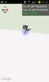
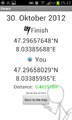
| Tue 30 Oct 2012 in 47,8: 47.2965765, 8.0338569 geohashing.info google osm bing/os kml crox |
Location
At the edge of a wood, only 900m away from Foehammers home
Participants
Plans
Having lots of free time at the moment, I plan on reaching the hash at around 1430. Since the closest road to the hash still is 400m away and there's probably 15cm of snow right now, it'll be quite some walk out there.
Expedition
What a surprise! Another geohash closer than one kilometre from my home, even closer than 2012-05-04 47 8! Of course I had to make it to this one.
As my plans never turn out the way I intend them to, I was busy until 1450 and then go convinced to go for a walk with my mom and our dog. Shortly after we started, I remembered the hash - luckily, I never leave the house without my phone so Geohash Droid was with me and we were even walking in the right direction.
I intended to make this a Tron Achievement hash, but because of the unconcious start, I probably messed that one up, the trail is in the gallery.
Halfway to the hash, my mom decided to go back home, another solo hash for me.
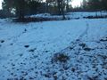
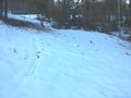
The way to the hash was very nice for the first few hundred metres - autumn-colored leaves mixed with the snow and some very nice weather make a good combination. The last 200 metres were a little less comfortable - the road wasn't more than a trail, covered in 15cm of snow. Nonetheless, I continued my journey towards the hash and found it after nearly zero hashdancing at ca. 1530. Nice view, but nothing spectacular.
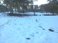
I trampled a huge hashmark in the snow (about 20m * 5m) and marked the spot as clear area. I also found time to build a little snowman =). Left the spot at 1550
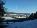
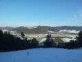
On my way home I found some weird prints in the snow that looked like some bird fought on the ground. I also got an amazing view of the alps and the Titlis (which is 65km away) unfortunately, the pictures my phone took, don't show what was visible.
I took some shortcut through the woods to avoid an already used junction, but there was no reasonable alternative for the last junction - see the trail pic.
Photos
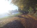
some leaves, some snow and the road
reached the spot!
as close as 48cm!

mandatory grinning
the brown spot is the hash, CD part from the mark above
X K C D
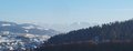
the view from the hash down the valley
the view uphill, KC part of the mark
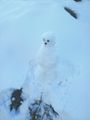
I made some company at the hash ;)
view from above the hash
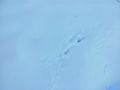
imprints from something like feathers
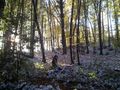
nice ambiance in the woods on my way home
The alps with Titlis in the middle
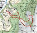
the journey I took - first/last junction screwes the Tron achievement
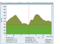
the distance and heightdifference I travelled


Achievements
Foehammer earned the Land geohash achievement
|
Foehammer earned the Walk geohash Achievement
|
Foehammer earned the Snowman Geohash Achievement
|
