Difference between revisions of "2012-10-31 50 8"
From Geohashing
imported>Mampfred (Created page with "{{subst:Expedition |lat = 50 |lon = 8 |date = 2012-10-31 }}") |
imported>Mampfred |
||
| Line 1: | Line 1: | ||
| − | |||
| − | |||
| − | |||
| − | |||
| − | |||
| − | |||
| − | |||
| − | |||
| − | |||
| − | |||
{{meetup graticule | {{meetup graticule | ||
| lat=50 | | lat=50 | ||
| Line 15: | Line 5: | ||
}} | }} | ||
| − | |||
__NOTOC__ | __NOTOC__ | ||
== Location == | == Location == | ||
| − | + | In the woods near (or reasonably close to call it that ...) Hünstetten. | |
== Participants == | == Participants == | ||
| − | + | * [[User:Mampfred|Mampfred]] | |
| − | + | * [[User:LadyBB|LadyBB]] | |
| + | * [[User:EmmJay|EmmJay]] | ||
== Plans == | == Plans == | ||
| − | + | There happenes to be some spare time before lunch AND a geohash reasonably close by so we'll see what we can do. | |
== Expedition == | == Expedition == | ||
| − | + | We drove as close as possible to the hash which took us a good 25 minutes. Unfortunately the last part of our planned route was closed so we had to stop in a parking area quite a bit further away and walk a bit more than expected. | |
| + | |||
| + | GPS accuracy was rubbish as usual but we found the spot not far from a path. On the way back we stopped at a bench with a nice view so EmmJay could have a little break. All in all we walked about 6.1 km and the expedition took a good three hours. | ||
== Tracklog == | == Tracklog == | ||
| − | + | See [http://www.everytrail.com/view_trip.php?trip_id=1857965 here]. Driving not included. | |
== Photos == | == Photos == | ||
| − | |||
| − | |||
| − | |||
<gallery perrow="5"> | <gallery perrow="5"> | ||
| + | Image:2012-10-31_50_8_coordinates_reached.jpg | Coordinates reached | ||
| + | Image:2012-10-31_50_8_group_shot.jpg | Group shot at the hash | ||
| + | </gallery> | ||
| + | |||
| + | <gallery perrow="1"> | ||
| + | Image:2012-10-31_50_8_panorama.jpg | ||
</gallery> | </gallery> | ||
== Achievements == | == Achievements == | ||
{{#vardefine:ribbonwidth|800px}} | {{#vardefine:ribbonwidth|800px}} | ||
| − | + | * Land | |
| − | |||
| − | |||
| − | |||
| − | |||
| − | |||
| − | |||
| − | |||
| − | |||
| − | |||
| − | |||
| − | |||
[[Category:Expeditions]] | [[Category:Expeditions]] | ||
| − | |||
[[Category:Expeditions with photos]] | [[Category:Expeditions with photos]] | ||
| − | |||
| − | |||
| − | |||
| − | |||
| − | |||
[[Category:Coordinates reached]] | [[Category:Coordinates reached]] | ||
| − | |||
| − | |||
| − | |||
| − | |||
| − | |||
| − | |||
| − | |||
| − | |||
| − | |||
| − | |||
| − | |||
| − | |||
| − | |||
| − | |||
| − | |||
| − | |||
| − | |||
| − | |||
Revision as of 13:21, 1 November 2012
| Wed 31 Oct 2012 in 50,8: 50.2209008, 8.1608167 geohashing.info google osm bing/os kml crox |
Location
In the woods near (or reasonably close to call it that ...) Hünstetten.
Participants
Plans
There happenes to be some spare time before lunch AND a geohash reasonably close by so we'll see what we can do.
Expedition
We drove as close as possible to the hash which took us a good 25 minutes. Unfortunately the last part of our planned route was closed so we had to stop in a parking area quite a bit further away and walk a bit more than expected.
GPS accuracy was rubbish as usual but we found the spot not far from a path. On the way back we stopped at a bench with a nice view so EmmJay could have a little break. All in all we walked about 6.1 km and the expedition took a good three hours.
Tracklog
See here. Driving not included.
Photos
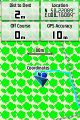
Coordinates reached
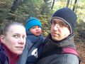
Group shot at the hash


Achievements
- Land