Difference between revisions of "2012-11-06 48 8"
imported>RecentlyChanged (→Achievements) |
imported>FippeBot m (Location) |
||
| (One intermediate revision by one other user not shown) | |||
| Line 1: | Line 1: | ||
| − | |||
<!-- If you did not specify these parameters in the template, please substitute appropriate values for IMAGE, LAT, LON, and DATE (YYYY-MM-DD format) | <!-- If you did not specify these parameters in the template, please substitute appropriate values for IMAGE, LAT, LON, and DATE (YYYY-MM-DD format) | ||
| Line 15: | Line 14: | ||
}} | }} | ||
| − | + | ||
__NOTOC__ | __NOTOC__ | ||
== Location == | == Location == | ||
| Line 21: | Line 20: | ||
== Participants == | == Participants == | ||
| − | [[User:RecentlyChanged|RecentlyChanged]] | + | * [[User:RecentlyChanged|RecentlyChanged]] |
== Plans == | == Plans == | ||
| − | Driving with my bike from Kleinsteinbach over Stupferich to the Hashpoint (like | + | Driving with my bike from Kleinsteinbach over Stupferich to the Hashpoint (like Google suggests if you pretend to walk) |
== Expedition == | == Expedition == | ||
| − | I started with my bike at 4:30 pm and and came to Stupferich. Shortly after there the sun goes down. I thought about riding back, | + | I started with my bike at 4:30 pm and and came to Stupferich. Shortly after there the sun goes down. I thought about riding back, because I haven't even made half of the way to the Hashpoint, and of course I have to ride back. |
| − | But I don't | + | But I don't give up and it wasn't this quick dark as expected. I came to Waldbronn without problems. From there it wasn't far to Spessart and Í made my way through the forest with a bit of luck because there was really an almost straight way to Spessart so I could follow my GPS. |
| − | The way back was | + | |
| + | The way back was far trickier. From Spessart down I took a road which didn't end in Waldbronn as expected, but I realised this later, after driving up the hill. From there I tried to ride back to the way I already knew, but I failed epically so I just made a little extra loop. But I would have missed the feeling of being magically transported into the Slender game so: worth it. | ||
| + | |||
It is an interesting feeling to feel cold and bad, but being totally happy because I knew I made it, nothing could destroy it now | It is an interesting feeling to feel cold and bad, but being totally happy because I knew I made it, nothing could destroy it now | ||
| Line 38: | Line 39: | ||
== Photos == | == Photos == | ||
| − | + | ||
| − | |||
| − | |||
<gallery perrow="5"> | <gallery perrow="5"> | ||
Image:2012-11-06 48 8 sunset.JPG|The sun goes down way to early... | Image:2012-11-06 48 8 sunset.JPG|The sun goes down way to early... | ||
Image:2012-11-06 48 8 quarry.JPG|Another quarry, beautiful | Image:2012-11-06 48 8 quarry.JPG|Another quarry, beautiful | ||
| − | Image:2012-11-06 48 8 proof-stupidgrin.JPG|proof and stupid grin in one, okay I admit | + | Image:2012-11-06 48 8 proof-stupidgrin.JPG|proof and stupid grin in one, okay I admit there's no grin |
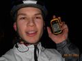
Image:2012-11-06 48 8 proof.JPG|I know it's a little bit shaky | Image:2012-11-06 48 8 proof.JPG|I know it's a little bit shaky | ||
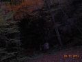
| − | Image:2012-11-06 48 8 theGeohash.JPG|The Geohash... most | + | Image:2012-11-06 48 8 theGeohash.JPG|The Geohash... most senseless pic I ever made |
Image:2012-11-06 48 8 slender1.JPG|Ever played Slender? | Image:2012-11-06 48 8 slender1.JPG|Ever played Slender? | ||
| − | Image:2012-11-06 48 8 slender2.JPG| I got the feeling :D | + | Image:2012-11-06 48 8 slender2.JPG|I got the feeling :D |
</gallery> | </gallery> | ||
| Line 54: | Line 53: | ||
{{#vardefine:ribbonwidth|800px}} | {{#vardefine:ribbonwidth|800px}} | ||
{{Bicycle geohash | latitude = 48 | longitude = 8 | date = 2012-11-06 | name = RecentlyChanged | distance = 31.2km | bothways = true}} | {{Bicycle geohash | latitude = 48 | longitude = 8 | date = 2012-11-06 | name = RecentlyChanged | distance = 31.2km | bothways = true}} | ||
| + | {{Land geohash | latitude = 48 | longitude = 8 | date = 2012-11-06 | name = RecentlyChanged }} | ||
{{consecutive geohash | count = 2 | latitude = 49 | longitude = 8 | date = 2012-11-05 | name = RecentlyChanged }} | {{consecutive geohash | count = 2 | latitude = 49 | longitude = 8 | date = 2012-11-05 | name = RecentlyChanged }} | ||
| − | + | ||
[[Category:Expeditions]] | [[Category:Expeditions]] | ||
[[Category:Expeditions with photos]] | [[Category:Expeditions with photos]] | ||
[[Category:Coordinates reached]] | [[Category:Coordinates reached]] | ||
| + | {{location|DE|BW|KA}} | ||
Latest revision as of 06:48, 13 August 2019
| Tue 6 Nov 2012 in 48,8: 48.9128349, 8.4304053 geohashing.info google osm bing/os kml crox |
Location
In the middle of a little village, probably in, on, under a building.
Participants
Plans
Driving with my bike from Kleinsteinbach over Stupferich to the Hashpoint (like Google suggests if you pretend to walk)
Expedition
I started with my bike at 4:30 pm and and came to Stupferich. Shortly after there the sun goes down. I thought about riding back, because I haven't even made half of the way to the Hashpoint, and of course I have to ride back. But I don't give up and it wasn't this quick dark as expected. I came to Waldbronn without problems. From there it wasn't far to Spessart and Í made my way through the forest with a bit of luck because there was really an almost straight way to Spessart so I could follow my GPS.
The way back was far trickier. From Spessart down I took a road which didn't end in Waldbronn as expected, but I realised this later, after driving up the hill. From there I tried to ride back to the way I already knew, but I failed epically so I just made a little extra loop. But I would have missed the feeling of being magically transported into the Slender game so: worth it.
It is an interesting feeling to feel cold and bad, but being totally happy because I knew I made it, nothing could destroy it now
After a little while I found Langensteinbach, and there I met a nice biker which could direct me into the right direction. Yay, I made it and being back at 7 pm. I took an hot shower and now my body feels good like me.
Tracklog
http://www.everytrail.com/view_trip.php?trip_id=1870519&code=18b4d95adba004c0e778c117afe58919
Photos
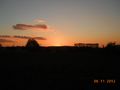
The sun goes down way to early...
Another quarry, beautiful
proof and stupid grin in one, okay I admit there's no grin

I know it's a little bit shaky

The Geohash... most senseless pic I ever made

Ever played Slender?
I got the feeling :D


Achievements
RecentlyChanged earned the Bicycle geohash achievement
|
RecentlyChanged earned the Land geohash achievement
|
RecentlyChanged earned the Consecutive geohash achievement
|