Difference between revisions of "2012-11-09 52 5"
From Geohashing
imported>Eupeodes |
imported>FippeBot m (Location) |
||
| (One intermediate revision by one other user not shown) | |||
| Line 31: | Line 31: | ||
== Photos == | == Photos == | ||
| − | |||
| − | |||
| − | |||
| − | |||
<gallery perrow="5"> | <gallery perrow="5"> | ||
| + | Image:2012-11-09_52_5_bike.JPG | Bike, hash is just behind the tree | ||
| + | Image:2012-11-09_52_5_location.JPG | GPS screen 1 | ||
| + | Image:2012-11-09_52_5_location2.JPG | GPS screen 2 | ||
| + | Image:2012-11-09_52_5_me.JPG | Me | ||
</gallery> | </gallery> | ||
| Line 45: | Line 45: | ||
[[Category:Coordinates reached]] | [[Category:Coordinates reached]] | ||
[[Category: Eupeodes]] | [[Category: Eupeodes]] | ||
| + | {{location|NL|GE}} | ||
Latest revision as of 06:49, 13 August 2019
| Fri 9 Nov 2012 in 52,5: 52.0311315, 5.7180439 geohashing.info google osm bing/os kml crox |
Location
On the southern part of the Ginkelse Heide, in the middle of the field in the area where kites are allowed.
Participants
Eupeodes went beginning of the afternoon
Plans
Cycle there, take some pictures, go to university
Expedition
I went there, took the pictures and went back to university, estimated to use 1 hour, appeared to be 1,5, but since the practical I had to attend was not obligatory there was no problem.
Photos
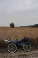
Bike, hash is just behind the tree
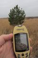
GPS screen 1
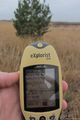
GPS screen 2

Me


Achievements
Not much interesting, I reached a land geohash by bike. Did not bring my kite because I did not think of it before now (and since it dark now I am not allowed to go there now). And no new graticule either.