Difference between revisions of "2012-11-11 32 -116"
imported>LucasBrown ([live] Hi) |
imported>FippeBot m (Location) |
||
| (8 intermediate revisions by 2 users not shown) | |||
| Line 1: | Line 1: | ||
| + | {{meetup graticule | lat=32 | lon=-116 | date=2012-11-11}} | ||
| − | |||
| − | |||
| − | |||
| − | |||
| − | |||
| − | |||
| − | |||
| − | |||
| − | |||
| − | |||
| − | |||
| − | |||
| − | |||
| − | |||
| − | |||
| − | |||
__NOTOC__ | __NOTOC__ | ||
== Location == | == Location == | ||
| − | + | Near some power lines just west of Potrero, CA | |
== Participants == | == Participants == | ||
| − | + | [[User:LucasBrown|LucasBrown]] | |
| − | |||
| − | |||
| − | |||
| − | |||
== Expedition == | == Expedition == | ||
| − | + | This was not an easy hash. The planned route required an elevation gain of 520 feet in the space of 2000 feet as the crow flies, but first a descent to a streambed added some fifty feet to the elevation gain and cut about 300 feet off the distance. After the streambed, the route went straight up a mountainside covered in boulders and dense chaparral to a power line tower. This rose about 300 feet vertically over about the same distance horizontally. The route then turned onto the tower's access road, which proceeded horizontally for about 800 feet, whereupon the route one again turned into the brush. Another 500 horizontal and 270 vertical feet later, the hashpoint was reached. | |
| − | |||
| − | |||
| − | |||
| − | |||
| − | |||
== Photos == | == Photos == | ||
| − | |||
| − | |||
| − | |||
<gallery perrow="5"> | <gallery perrow="5"> | ||
| + | Image:2012-11-11_32_-116_19-05-58-164.jpg | Geohash Droid details page at the hashpoint | ||
| + | Image:2012-11-11_32_-116_19-06-41-197.jpg | Map at the hashpoint | ||
| + | Image:2012-11-11_32_-116_pano.jpg | Panorama looking southwest from the hashpoint as the sun sets behind Tecate Peak | ||
</gallery> | </gallery> | ||
== Achievements == | == Achievements == | ||
{{#vardefine:ribbonwidth|800px}} | {{#vardefine:ribbonwidth|800px}} | ||
| − | |||
| − | |||
| − | |||
| − | |||
| − | |||
| − | |||
| − | |||
| − | |||
| − | |||
| − | |||
| − | |||
[[Category:Expeditions]] | [[Category:Expeditions]] | ||
| − | |||
[[Category:Expeditions with photos]] | [[Category:Expeditions with photos]] | ||
| − | |||
[[Category:Expedition without GPS]] | [[Category:Expedition without GPS]] | ||
| − | |||
| − | |||
| − | |||
[[Category:Coordinates reached]] | [[Category:Coordinates reached]] | ||
| − | + | {{location|US|CA|SD}} | |
| − | |||
| − | |||
| − | |||
| − | |||
| − | |||
| − | |||
| − | |||
| − | |||
| − | |||
| − | |||
| − | |||
| − | |||
| − | |||
| − | |||
| − | |||
| − | |||
| − | |||
Latest revision as of 06:50, 13 August 2019
| Sun 11 Nov 2012 in 32,-116: 32.6033624, -116.6477091 geohashing.info google osm bing/os kml crox |
Location
Near some power lines just west of Potrero, CA
Participants
Expedition
This was not an easy hash. The planned route required an elevation gain of 520 feet in the space of 2000 feet as the crow flies, but first a descent to a streambed added some fifty feet to the elevation gain and cut about 300 feet off the distance. After the streambed, the route went straight up a mountainside covered in boulders and dense chaparral to a power line tower. This rose about 300 feet vertically over about the same distance horizontally. The route then turned onto the tower's access road, which proceeded horizontally for about 800 feet, whereupon the route one again turned into the brush. Another 500 horizontal and 270 vertical feet later, the hashpoint was reached.
Photos

Geohash Droid details page at the hashpoint
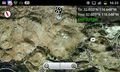
Map at the hashpoint
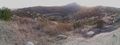
Panorama looking southwest from the hashpoint as the sun sets behind Tecate Peak

