Difference between revisions of "2012-11-13 -35 149"
imported>1PE (Created page with "{{subst:Expedition |lat = -35 |lon = 149 |date = 2012-11-13 }}") |
m (More specific location) |
||
| (9 intermediate revisions by 2 users not shown) | |||
| Line 1: | Line 1: | ||
| − | + | [[Image:{{{image|2012-11-13_-35_149_letterbox_sign.JPG}}}|thumb|left]] | |
| − | |||
| − | |||
| − | |||
| − | |||
| − | |||
| − | |||
| − | |||
{{meetup graticule | {{meetup graticule | ||
| lat=-35 | | lat=-35 | ||
| Line 18: | Line 11: | ||
__NOTOC__ | __NOTOC__ | ||
== Location == | == Location == | ||
| − | + | Beside the farm dam on a "private block" in Wamboin, an area to the north-west of Canberra that have become small farmlets with significant houses, rather than the former large open-range sheep and cattle farms. There might be a gate just off the public road, so I may be prevented from getting even a picture of the dam. | |
== Participants == | == Participants == | ||
| − | + | [[User:1PE|1PE]] | |
| − | |||
== Plans == | == Plans == | ||
| − | + | ===[[User:1PE|1PE]]=== | |
| + | A lunchtime drive in the country. | ||
== Expedition == | == Expedition == | ||
| − | + | ===[[User:1PE|1PE]]=== | |
| + | During my lunch break, I drove the roughly 25km and passed [[2012-09-07 -35 149|two]] [[2012-09-07 -35 149|previous]] geohashes of mine. | ||
| + | |||
| + | I found the short access road and its terminal roundabout as expected. There was a block/farm access road at the roundabout going down to the block with the letterbox and its number (that was faded). Just beyond was a large treee with a prominent sign saying this "Private Property - No Through Road". Accordingly, not wanting to trespass, I remained near the gate and recorded the occasion with photographs, and left a print-out of the [http://carabiner.peeron.com/xkcd/map/map.html Peeron] map with a hand-written note to the land owner. The property appears on a local land agent's website from when it last sold, complete with a picture showing in the background the dam and the site of the geohash. | ||
| − | + | Note: The photos will appear much later in the day. | |
| − | |||
== Photos == | == Photos == | ||
| Line 38: | Line 33: | ||
--> | --> | ||
<gallery perrow="5"> | <gallery perrow="5"> | ||
| + | Image:2012-11-13_-35_149_roundabout.JPG|The end of the road - the roundabout - with access and letterbox to the right. | ||
| + | Image:2012-11-13_-35_149_letterbox_sign.JPG|Letterbox, and 'the' sign on the tree behind. | ||
| + | Image:2012-11-13_-35_149_power.JPG|Power to the people! The power supply for two blocks. | ||
</gallery> | </gallery> | ||
| Line 44: | Line 42: | ||
<!-- Add any achievement ribbons you earned below, or remove this section --> | <!-- Add any achievement ribbons you earned below, or remove this section --> | ||
| − | |||
| − | |||
| − | |||
| − | |||
| − | |||
| − | |||
| − | |||
| − | |||
| − | |||
| − | |||
| − | |||
[[Category:Expeditions]] | [[Category:Expeditions]] | ||
| − | |||
| − | |||
| − | |||
| − | |||
| − | |||
| − | |||
| − | |||
| − | |||
| − | |||
| − | |||
| − | |||
[[Category:Coordinates not reached]] | [[Category:Coordinates not reached]] | ||
| − | |||
| − | |||
| − | |||
| − | |||
| − | |||
[[Category:Not reached - No public access]] | [[Category:Not reached - No public access]] | ||
| − | + | [[Category:Expeditions with photos]] | |
| − | + | {{location|AU|NSW|QB}} | |
| − | [[Category: | ||
| − | |||
| − | |||
| − | |||
| − | |||
| − | |||
Latest revision as of 12:26, 1 August 2020

| Tue 13 Nov 2012 in -35,149: -35.2382889, 149.3517381 geohashing.info google osm bing/os kml crox |
Location
Beside the farm dam on a "private block" in Wamboin, an area to the north-west of Canberra that have become small farmlets with significant houses, rather than the former large open-range sheep and cattle farms. There might be a gate just off the public road, so I may be prevented from getting even a picture of the dam.
Participants
Plans
1PE
A lunchtime drive in the country.
Expedition
1PE
During my lunch break, I drove the roughly 25km and passed two previous geohashes of mine.
I found the short access road and its terminal roundabout as expected. There was a block/farm access road at the roundabout going down to the block with the letterbox and its number (that was faded). Just beyond was a large treee with a prominent sign saying this "Private Property - No Through Road". Accordingly, not wanting to trespass, I remained near the gate and recorded the occasion with photographs, and left a print-out of the Peeron map with a hand-written note to the land owner. The property appears on a local land agent's website from when it last sold, complete with a picture showing in the background the dam and the site of the geohash.
Note: The photos will appear much later in the day.
Photos
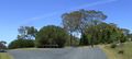
The end of the road - the roundabout - with access and letterbox to the right.
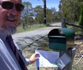
Letterbox, and 'the' sign on the tree behind.
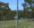
Power to the people! The power supply for two blocks.

