Difference between revisions of "2012-11-15 42 27"
From Geohashing
imported>Kisolre m (→Photos) |
imported>FippeBot m (Location) |
||
| (One intermediate revision by one other user not shown) | |||
| Line 1: | Line 1: | ||
| − | |||
<!-- If you did not specify these parameters in the template, please substitute appropriate values for IMAGE, LAT, LON, and DATE (YYYY-MM-DD format) | <!-- If you did not specify these parameters in the template, please substitute appropriate values for IMAGE, LAT, LON, and DATE (YYYY-MM-DD format) | ||
| Line 50: | Line 49: | ||
| − | |||
| − | |||
| − | |||
| − | |||
| − | |||
| − | |||
| − | |||
| − | |||
| − | |||
| − | |||
[[Category:Expeditions]] | [[Category:Expeditions]] | ||
| − | + | [[Category:Expeditions with photos]] | |
| − | [[Category:Expeditions with photos]] | ||
| − | |||
| − | |||
| − | |||
| − | |||
| − | |||
[[Category:Coordinates reached]] | [[Category:Coordinates reached]] | ||
| − | + | {{location|BG|B}} | |
| − | |||
| − | |||
| − | |||
| − | |||
| − | |||
| − | |||
| − | |||
| − | |||
| − | |||
| − | |||
| − | |||
| − | |||
| − | |||
| − | |||
| − | |||
| − | |||
| − | |||
Latest revision as of 06:53, 13 August 2019
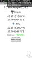
| Thu 15 Nov 2012 in 42,27: 42.9115158, 27.7640643 geohashing.info google osm bing/os kml crox |
Location
In an oak forest near Unec village.
Participants
Kisolre and Vania.
Plans
To have a walk in the forest if the weather and terrain were appropriate.
Expedition
We drove the main road to about 400m from the hash. There was unpaved road to about 160m but our car has low clearance and I didn't want to take any chances. We followed the unpaved road to the nearest possible point and then went in to the forest. There was a meteo observation site or something like that near the hash. It seemed abandoned. The forest was not very dense so no problem reaching the hash. We took some pictures and headed home.
Tracklog
no track log for this expedition :(
Photos

At the geohash. @42.9115,27.7640
Proof @42.9115,27.7640
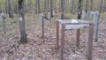
Looks like some kind of meteo info gathering site


