Difference between revisions of "2012-11-20 41 -70"
imported>Vbob (→Photos) |
imported>FippeBot m (Location) |
||
| (8 intermediate revisions by 2 users not shown) | |||
| Line 19: | Line 19: | ||
<!-- where you've surveyed the hash to be --> | <!-- where you've surveyed the hash to be --> | ||
| − | A few miles north of where the Acushnet River meets Buzzards Bay, the long-silent massive brick mills have once again fallen silent, as the projects to renovate them into loft apartments, studio | + | A few miles north of where the Acushnet River meets Buzzards Bay, the long-silent massive brick mills have once again fallen silent, as the projects to renovate them into loft apartments, studio condos, and yet more little shops await a freshened economy. The shoreline is littered with decaying pilings, rusting fences, piles of pallets and broken concrete. A geotrasher would barely know where to begin! |
== Participants == | == Participants == | ||
| Line 33: | Line 33: | ||
== Expedition == | == Expedition == | ||
<!-- how it all turned out. your narrative goes here. --> | <!-- how it all turned out. your narrative goes here. --> | ||
| − | + | I wandered around one end of a curious brick building only to find chain link fence running down into the water. A hole in the fence led to more broken glass and poison ivy than seemed worth wading through. Around the other end of the building was long concrete wall - but it was broken down at the north end, giving easy access to a gravelly patch of low weeds and the hashpoint of desire. | |
| − | |||
| − | |||
== Photos == | == Photos == | ||
| Line 42: | Line 40: | ||
--> | --> | ||
<gallery perrow="5"> | <gallery perrow="5"> | ||
| + | Image:2012 11 20 40 -70 A.jpg | behind this building | ||
| + | Image:2012 11 20 40 -70 B.jpg | but maybe not this way | ||
| + | Image:2012 11 20 40 -70 C.jpg | much broken glass and poison ivy through here... | ||
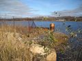
| + | Image:2012 11 20 40 -70 D.jpg | easy walk around the other end through break in concrete wall | ||
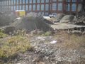
| + | Image:2012 11 20 40 -70 F.jpg | hard to know what is Geotrash, and what is precious construction materials.... | ||
| + | Image:2012 11 20 40 -70 G.jpg | as close as I can tell | ||
| + | Image:2012 11 20 40 -70 H.jpg | Vbob | ||
| + | |||
| + | |||
| + | |||
</gallery> | </gallery> | ||
| − | |||
| − | |||
== Achievements == | == Achievements == | ||
| Line 50: | Line 56: | ||
<!-- Add any achievement ribbons you earned below, or remove this section --> | <!-- Add any achievement ribbons you earned below, or remove this section --> | ||
| + | {{land geohash | ||
| + | | latitude = 41 | ||
| + | | longitude = -70 | ||
| + | | date = 2012-11-20 | ||
| + | | name = Vbob | ||
| − | + | }} | |
| − | |||
| − | |||
| − | |||
| − | |||
| − | |||
| − | |||
| − | |||
| Line 64: | Line 68: | ||
[[Category:Expeditions with photos]] | [[Category:Expeditions with photos]] | ||
[[Category:Coordinates reached]] | [[Category:Coordinates reached]] | ||
| − | + | {{location|US|MA|BR}} | |
| − | |||
| − | |||
| − | |||
| − | |||
| − | |||
| − | |||
| − | |||
| − | |||
| − | |||
| − | |||
| − | |||
| − | |||
| − | |||
| − | |||
| − | |||
| − | |||
| − | |||
| − | |||
| − | |||
| − | |||
| − | |||
| − | |||
| − | |||
| − | |||
| − | |||
Latest revision as of 05:22, 6 August 2019
| Tue 20 Nov 2012 in 41,-70: 41.6668560, -70.9190832 geohashing.info google osm bing/os kml crox |
Location
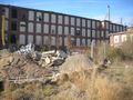
A few miles north of where the Acushnet River meets Buzzards Bay, the long-silent massive brick mills have once again fallen silent, as the projects to renovate them into loft apartments, studio condos, and yet more little shops await a freshened economy. The shoreline is littered with decaying pilings, rusting fences, piles of pallets and broken concrete. A geotrasher would barely know where to begin!
Participants
Plans
The original plan was to take off early after lunch on a REALLY slow school day, and head west for 2012-11-20 41 -71; but an unexpected errand to the east meant I would be PAID to drive towards this hashpoint....but without pausing to announce same.
Expedition
I wandered around one end of a curious brick building only to find chain link fence running down into the water. A hole in the fence led to more broken glass and poison ivy than seemed worth wading through. Around the other end of the building was long concrete wall - but it was broken down at the north end, giving easy access to a gravelly patch of low weeds and the hashpoint of desire.
Photos
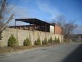
behind this building
but maybe not this way
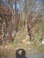
much broken glass and poison ivy through here...
easy walk around the other end through break in concrete wall
hard to know what is Geotrash, and what is precious construction materials....
as close as I can tell
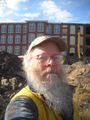
Vbob


Achievements
Vbob earned the Land geohash achievement
|