Difference between revisions of "2012-11-22 49 8"
imported>RecentlyChanged (→Expedition) |
imported>FippeBot m (Location) |
||
| (3 intermediate revisions by 3 users not shown) | |||
| Line 1: | Line 1: | ||
| − | |||
| − | |||
| − | |||
| − | |||
| − | |||
| − | |||
| − | |||
| − | |||
| − | |||
| − | |||
{{meetup graticule | {{meetup graticule | ||
| lat=49 | | lat=49 | ||
| Line 27: | Line 17: | ||
== Expedition == | == Expedition == | ||
| − | We met at 7 pm in Karlsruhe at the tramstation. There we decided almost spontaneous to take the "4". While sitting in the tram we looked up the tramstation where we will exit. | + | We met at 7 pm in Karlsruhe at the tramstation. There we decided almost spontaneous to take the No. "4". While sitting in the tram we looked up the tramstation where we will exit. |
| − | What we | + | What we didn't know: this tram won't drive to this right tramstation. Luckily RecentlyChanged switched his GPS device on just at the nearest point to the Hash and saw how the distance to the Hash started to grow again, and that it was almost perfectly in the east and the tram was on the way north. Good for us, we would have been waiting for a long time to reach the right tram station (probably never). |
| − | It | + | It turned out that it wasn't as bad as we expected, we had to do just a short walk (approx. 15 min) until we arrive at the hash. And we had enough time anyway. |
| − | After | + | After having made pics at the hash, we took the tram from the second closest station (again failed) and went back to Karlsruhe, to wait for the next day. |
You be interested how the narrative goes on? Read this: [[2012-11-23 49 8]]. (It's way more interesting!) | You be interested how the narrative goes on? Read this: [[2012-11-23 49 8]]. (It's way more interesting!) | ||
| Line 47: | Line 37: | ||
== Achievements == | == Achievements == | ||
{{#vardefine:ribbonwidth|800px}} | {{#vardefine:ribbonwidth|800px}} | ||
| − | + | {{Public transport geohash | latitude = 49 | longitude = 8 | date = 2012-11-22 | busline = KVV | name = Deuded and RecentlyChanged}} | |
| + | {{land geohash | latitude = 49 | longitude = 8 | date = 2012-11-22 | busline = KVV | name = Deuded and RecentlyChanged}} | ||
| − | |||
| − | |||
| − | |||
| − | |||
| − | |||
| − | |||
| − | |||
| − | |||
| − | |||
| − | |||
| − | |||
[[Category:Expeditions]] | [[Category:Expeditions]] | ||
| − | + | [[Category:Expeditions with photos]] | |
| − | [[Category:Expeditions with photos]] | ||
| − | |||
| − | |||
| − | |||
| − | |||
| − | |||
[[Category:Coordinates reached]] | [[Category:Coordinates reached]] | ||
| − | + | {{location|DE|BW|KA|city=true}} | |
| − | |||
| − | |||
| − | |||
| − | |||
| − | |||
| − | |||
| − | |||
| − | |||
| − | |||
| − | |||
| − | |||
| − | |||
| − | |||
| − | |||
| − | |||
| − | |||
| − | |||
Latest revision as of 06:57, 13 August 2019
| Thu 22 Nov 2012 in 49,8: 49.0334635, 8.4619523 geohashing.info google osm bing/os kml crox |
Location
A field, wow x)
Participants
Planned RecentlyChanged and Deuded, probably we drag along a friend
Plans
Take a tram at 7pm in the Kaiserstraße. Looking where we will end.
Expedition
We met at 7 pm in Karlsruhe at the tramstation. There we decided almost spontaneous to take the No. "4". While sitting in the tram we looked up the tramstation where we will exit. What we didn't know: this tram won't drive to this right tramstation. Luckily RecentlyChanged switched his GPS device on just at the nearest point to the Hash and saw how the distance to the Hash started to grow again, and that it was almost perfectly in the east and the tram was on the way north. Good for us, we would have been waiting for a long time to reach the right tram station (probably never). It turned out that it wasn't as bad as we expected, we had to do just a short walk (approx. 15 min) until we arrive at the hash. And we had enough time anyway. After having made pics at the hash, we took the tram from the second closest station (again failed) and went back to Karlsruhe, to wait for the next day.
You be interested how the narrative goes on? Read this: 2012-11-23 49 8. (It's way more interesting!)
Tracklog
http://www.everytrail.com/view_trip.php?trip_id=1892911
Photos
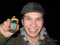
Proof and StupidGrin for RecentlyChanged
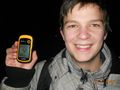
and for Deuded

Not much else to see there


Achievements
Deuded and RecentlyChanged earned the Public transport geohash achievement
|
Deuded and RecentlyChanged earned the Land geohash achievement
|