Difference between revisions of "2012-11-24 48 8"
imported>RecentlyChanged (→Tracklog) |
imported>FippeBot m (Location) |
||
| (8 intermediate revisions by 2 users not shown) | |||
| Line 1: | Line 1: | ||
| − | |||
<!-- If you did not specify these parameters in the template, please substitute appropriate values for IMAGE, LAT, LON, and DATE (YYYY-MM-DD format) | <!-- If you did not specify these parameters in the template, please substitute appropriate values for IMAGE, LAT, LON, and DATE (YYYY-MM-DD format) | ||
| Line 21: | Line 20: | ||
== Participants == | == Participants == | ||
| − | RecentlyChanged | + | [[User:RecentlyChanged|RecentlyChanged]] |
== Plans == | == Plans == | ||
| Line 33: | Line 32: | ||
Until everything was so easy I decided to make a Tron out of it, and even this worked well. It helped of course that I knew a big part of the way back from [[2012-11-06 48 8]]. | Until everything was so easy I decided to make a Tron out of it, and even this worked well. It helped of course that I knew a big part of the way back from [[2012-11-06 48 8]]. | ||
| − | + | Now that I'm back all my batteries are low, from photo, GPS-device and clock. Either I'm lucky, or it was to cold outside. | |
This going to be a good day. | This going to be a good day. | ||
| Line 41: | Line 40: | ||
== Photos == | == Photos == | ||
| − | |||
| − | |||
| − | |||
<gallery perrow="5"> | <gallery perrow="5"> | ||
| + | Image:2012-11-24 48 8 SG-Proof.JPG|Stupid Grin with proof | ||
| + | Image:2012-11-24 48 8 Time-Proof.JPG| and proofed location + time | ||
| + | Image:2012-11-24 48 8 Hashtree.JPG| I had to call him Hashtree | ||
| + | Image:2012-11-24 48 8 East.JPG| This is what I saw eastward (it wasn't really this bright -> sunrise-mode of camera | ||
| + | Image:2012-11-24 48 8 Marker.JPG| Hey, my first marker with proof | ||
| + | Image:2012-11-24 48 8 Map.JPG| The genius map | ||
</gallery> | </gallery> | ||
== Achievements == | == Achievements == | ||
{{#vardefine:ribbonwidth|800px}} | {{#vardefine:ribbonwidth|800px}} | ||
| − | + | {{land geohash | latitude = 48 | longitude = 8| date = 2012-11-24 | name = RecentlyChanged}} | |
| + | {{Bicycle geohash | latitude = 48 | longitude = 8| date = 2012-11-24 | name = RecentlyChanged | distance = 19.5 miles | bothways = true}} | ||
| + | {{Tron | latitude = 48| longitude = 8| date = 2012-11-24| name = RecentlyChanged| http://www.everytrail.com/view_trip.php?trip_id=1895517| possessive = his }} | ||
| + | {{consecutive geohash | count = 3 | latitude = 49 | longitude = 8| date = 2012-11-22 | name = RecentlyChanged}} | ||
| + | {{Sunrise geohash | latitude = 48 | longitude = 8| date = 2012-11-24 | name = RecentlyChanged}} | ||
| + | {{Geobrush | ||
| + | | latitude = 48 | longitude = 8| date = 2012-11-24 | name = RecentlyChanged | ||
| + | | form = drafted map | ||
| + | | image = 2012-11-24 48 8 Map.JPG | ||
| + | }} | ||
| − | |||
| − | |||
| − | |||
| − | |||
| − | |||
| − | |||
| − | |||
| − | |||
| − | |||
| − | |||
| − | |||
[[Category:Expeditions]] | [[Category:Expeditions]] | ||
| − | + | [[Category:Expeditions with photos]] | |
| − | [[Category:Expeditions with photos]] | ||
| − | |||
| − | |||
| − | |||
| − | |||
| − | |||
[[Category:Coordinates reached]] | [[Category:Coordinates reached]] | ||
| − | + | {{location|DE|BW|PF}} | |
| − | |||
| − | |||
| − | |||
| − | |||
| − | |||
| − | |||
| − | |||
| − | |||
| − | |||
| − | |||
| − | |||
| − | |||
| − | |||
| − | |||
| − | |||
| − | |||
| − | |||
Latest revision as of 06:59, 13 August 2019
| Sat 24 Nov 2012 in 48,8: 48.8821370, 8.5743111 geohashing.info google osm bing/os kml crox |
Location
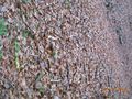
Forest...
Participants
Plans
Stand up early to be there at sunrise :)
Expedition
Geohashing is a crazy thing!
I never stand up at 6:30am just to do something such senseless, not even for things with more importance. But today I've done it, stod up at 6:30am and started my journey with the bike, just after drawing a little map which is the only reason I made it in time. At this time of day, on weekend, it is incredibly quiet and the streets almost clear (and its fresh, at about 3°C at the beginning, 6°C at the Hashpoint). It is too really easy to navigate, because you always know where east is. So I made it in a good half hour to the Hashpoint without any mistake (again, drawing the map was incredible). As I thought I might be near the Hash I was just 18 meters away, with a accuracy of 6 meters because of the forest. And it was almost exactly 8am just the time of the official sunset (as I hope, because google said it).
Until everything was so easy I decided to make a Tron out of it, and even this worked well. It helped of course that I knew a big part of the way back from 2012-11-06 48 8. Now that I'm back all my batteries are low, from photo, GPS-device and clock. Either I'm lucky, or it was to cold outside.
This going to be a good day.
Tracklog
http://www.everytrail.com/view_trip.php?trip_id=1895517
Photos
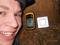
Stupid Grin with proof
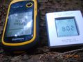
and proofed location + time
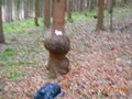
I had to call him Hashtree
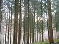
This is what I saw eastward (it wasn't really this bright -> sunrise-mode of camera
Hey, my first marker with proof
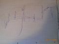
The genius map


Achievements
RecentlyChanged earned the Land geohash achievement
|
RecentlyChanged earned the Bicycle geohash achievement
|
RecentlyChanged earned the Tron achievement
|
RecentlyChanged earned the Consecutive geohash achievement
|
RecentlyChanged earned the Sunrise Geohash Achievement
|
RecentlyChanged earned the Geobrush achievement
|