Difference between revisions of "2012-11-25 52 10"
imported>TheOneRing m (Created page with "{{meetup graticule | lat=52 | lon=10 | date=2012-11-25 }} == Location == The geohash is located on a field near Königslutter am Elm. == Who went == [[User:TheOneRing|TheOneRin...") |
imported>TheOneRing (→TheOneRing) |
||
| Line 19: | Line 19: | ||
We parked at the church and the geohash was 900m as the bird flies. My parents didn't want to come with me (I wonder why), so I walked alone. It turned out that I should walk around a forest, because the direct way crossed the area of a hospital, the final distance was then about 1.5km. The consitions were very autumn-like: very muddy. I took several photographs and walked back to may parents, this time I didn't care about the hospital. | We parked at the church and the geohash was 900m as the bird flies. My parents didn't want to come with me (I wonder why), so I walked alone. It turned out that I should walk around a forest, because the direct way crossed the area of a hospital, the final distance was then about 1.5km. The consitions were very autumn-like: very muddy. I took several photographs and walked back to may parents, this time I didn't care about the hospital. | ||
| − | I met my parents in a café, where we had coffee and a piece of cake. Finally we drove back home, right in time, because it started to rain. Very nice but only a prologue for the geohash two days later. | + | I met my parents in a café, where we had coffee and a piece of cake. Finally we drove back home, right in time, because it started to rain. Very nice but only a prologue for the geohash [[2012-11-27 51 12 | two days later]]. |
| + | |||
== Photos == | == Photos == | ||
=== TheOneRing === | === TheOneRing === | ||
Revision as of 20:12, 28 November 2012
| Sun 25 Nov 2012 in 52,10: 52.2423049, 10.8042636 geohashing.info google osm bing/os kml crox |
Contents
Location
The geohash is located on a field near Königslutter am Elm.
Who went
TheOneRing and his parents - by car.
The Expedition
TheOneRing
"Let's make a trip. Ok, where do you want to go? Well, Königslutter am Elm, there's a geohash."
The conversation between my parent and me could have been like this, but we went. The weather was not very well, but at least no rain...for once. On the way to Königslutter there was nothing special, but in the city there is a Romanic church. Its interior was painted again in the 19th century and very colourful.
We parked at the church and the geohash was 900m as the bird flies. My parents didn't want to come with me (I wonder why), so I walked alone. It turned out that I should walk around a forest, because the direct way crossed the area of a hospital, the final distance was then about 1.5km. The consitions were very autumn-like: very muddy. I took several photographs and walked back to may parents, this time I didn't care about the hospital.
I met my parents in a café, where we had coffee and a piece of cake. Finally we drove back home, right in time, because it started to rain. Very nice but only a prologue for the geohash two days later.
Photos
TheOneRing
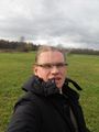
Hairdo?? Gone with the wind
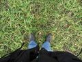
A pair of dirty shoes and a geohash
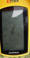
Right here
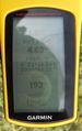
Some more information
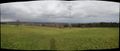
Two panoramic views...
...of the surroundings


Achievement
TheOneRing earned the Land geohash achievement
|
TheOneRing achieved level 1 of the Minesweeper Geohash achievement
|