Difference between revisions of "2012-11-28 61 23"
imported>Teukkam ([live picture] The proof. Nothing much here. The hash is about 5 m into the forest beyond the edge of the clearing. [http://www.openstreetmap.org/?lat=61.42130082&lon=23.87767391&zoom=16&layers=B000FTF @61.4213,23.8777]) |
imported>FippeBot m (Location) |
||
| (7 intermediate revisions by 2 users not shown) | |||
| Line 1: | Line 1: | ||
| − | |||
| − | |||
| − | |||
| − | |||
| − | |||
| − | |||
| − | |||
| − | |||
| − | |||
{{meetup graticule | {{meetup graticule | ||
| lat=61 | | lat=61 | ||
| Line 35: | Line 26: | ||
*Can't miss a hash this close to home. -- [[User:Teukkam|TeukkaM]] [http://www.openstreetmap.org/?lat=61.44805305&lon=23.83409598&zoom=16&layers=B000FTF @61.4481,23.8341] 07:04, 28 November 2012 (EET) | *Can't miss a hash this close to home. -- [[User:Teukkam|TeukkaM]] [http://www.openstreetmap.org/?lat=61.44805305&lon=23.83409598&zoom=16&layers=B000FTF @61.4481,23.8341] 07:04, 28 November 2012 (EET) | ||
| − | *Parked car here. Encountered a | + | So I set out to try and find this hash. The road I chose to park on was a very narrow dirt road. I was worried whether I could find a suitable parking spot in order to let other potential road-users pass. I finally parked exactly where Google Maps said would be the closest point on the road. There was a stop sign saying the road ahead was private, with another road branching to the left. The intersection seemed to have plenty of space to pass (at least for a normal vehicle), so I parked the hashmobile there. The car's thermometer was showing -3 degrees Celsius at this point. |
| + | |||
| + | *Parked car here. Encountered a muggle with a dog. Found out I had misconverted the coordinates for my eTrex so I had to reenter them, this time letting the GPS do the conversion itself... -- [[User:Teukkam|TeukkaM]] [http://www.openstreetmap.org/?lat=61.42355845&lon=23.87558984&zoom=16&layers=B000FTF @61.4236,23.8756] 08:46, 28 November 2012 (EET) | ||
| + | |||
| + | I entered the forest. The terrain was slightly boggy as I had anticipated. The moss was slightly crunchy from the effect of the freezing temperature. I really had to mind my step as there were water holes here and there. I had packed rubber boots but I didn't intend to use them unless absolutely necessary. Finally I decided to go through some higher ground to the west which turned out to be a good decision. | ||
*Punched through the forest to the clearing. The sun is not quite up yet. -- [[User:Teukkam|TeukkaM]] [http://www.openstreetmap.org/?lat=61.42188781&lon=23.87617229&zoom=16&layers=B000FTF @61.4219,23.8762] 08:53, 28 November 2012 (EET) | *Punched through the forest to the clearing. The sun is not quite up yet. -- [[User:Teukkam|TeukkaM]] [http://www.openstreetmap.org/?lat=61.42188781&lon=23.87617229&zoom=16&layers=B000FTF @61.4219,23.8762] 08:53, 28 November 2012 (EET) | ||
| + | |||
| + | It seems the forest here had been really thick before it was cleared for the power line. There was quite a brisk wind blowing along the "chute" made up by the clearing. I found the has point easily, it ended up being on the forest's side of the edge of the clearing, at the bottom of a steep slope. I then took the necessary photographs, of course forgetting to include myself in the photo. Hope the picture of my GPSr is sufficient proof I was there... I was just about to leave as I realised I should probably make some kind of a marker. I first intended to tie a paper handkerchief with an XKCD note on it to a spruce, but my ballpoint pen refused to work in the subzero temperature. I then built a marker out of spruce cones instead. | ||
| + | |||
| + | As often happens on trips like this, you only find the optimal route when leaving. There was an unmarked forestry vehicle track leading back to civilization slightly to the west of where I parked. As I approached the car, an SUV pulled over and the driver asked me if that was my car and I said yes. I was a bit worried what he would say next but he simply said that a large construction truck was about to come by and would probably not fit past my car. This was not a problem since I was just about to leave anyway. | ||
| + | |||
== Tracklog == | == Tracklog == | ||
<!-- if your GPS device keeps a log, you may post a link here --> | <!-- if your GPS device keeps a log, you may post a link here --> | ||
| Line 50: | Line 50: | ||
Image:2012-11-28_61_23_09-02-23-870.jpg | The proof. Nothing much here. The hash is about 5 m into the forest beyond the edge of the clearing. [http://www.openstreetmap.org/?lat=61.42130082&lon=23.87767391&zoom=16&layers=B000FTF @61.4213,23.8777] | Image:2012-11-28_61_23_09-02-23-870.jpg | The proof. Nothing much here. The hash is about 5 m into the forest beyond the edge of the clearing. [http://www.openstreetmap.org/?lat=61.42130082&lon=23.87767391&zoom=16&layers=B000FTF @61.4213,23.8777] | ||
| + | |||
| + | Image:2012-11-28_61_23_09-09-29-341.jpg | Cone marker left on the scene [http://www.openstreetmap.org/?lat=61.42130000&lon=23.87740000&zoom=16&layers=B000FTF @61.4213,23.8774] | ||
| + | |||
| + | Image:2012-11-28_61_23_09-14-09-140.jpg | Mooses like power line clearings too. [http://www.openstreetmap.org/?lat=61.44180000&lon=23.86180000&zoom=16&layers=B000FTF @61.4418,23.8618] | ||
| + | |||
| + | Image:2012-11-28_61_23_09-14-59-202.jpg | [http://www.openstreetmap.org/?lat=61.42140000&lon=23.87710000&zoom=16&layers=B000FTF @61.4214,23.8771] | ||
</gallery> | </gallery> | ||
| Line 55: | Line 61: | ||
{{#vardefine:ribbonwidth|800px}} | {{#vardefine:ribbonwidth|800px}} | ||
<!-- Add any achievement ribbons you earned below, or remove this section --> | <!-- Add any achievement ribbons you earned below, or remove this section --> | ||
| + | {{land geohash | ||
| + | | latitude = 61 | ||
| + | | longitude = 23 | ||
| + | | date = 2012-11-28 | ||
| + | | name = Teukkam | ||
| + | }} | ||
| + | {{Frozen Geohash | ||
| + | | latitude = 61 | ||
| + | | longitude = 23 | ||
| + | | date = 2012-11-28 | ||
| + | | temperature = -3°C | ||
| + | | name = Teukkam | ||
| + | | image = 2012-11-28_61_23_08-34-57-378.jpg | ||
| + | }} | ||
| + | {{Sunrise geohash | ||
| + | | latitude = 61 | ||
| + | | longitude = 23 | ||
| + | | date = 2012-11-28 | ||
| + | | name = TeukkaM | ||
| + | | image = Teukkam_Sunrise2811.jpg | ||
| + | }} | ||
| + | [[Category:Expeditions]] | ||
| − | |||
| − | |||
| − | |||
| − | |||
| − | |||
| − | |||
| − | |||
| − | |||
| − | |||
| − | |||
| − | |||
| − | |||
[[Category:Expeditions with photos]] | [[Category:Expeditions with photos]] | ||
| − | |||
| − | |||
| − | |||
| − | |||
[[Category:Coordinates reached]] | [[Category:Coordinates reached]] | ||
| − | + | {{location|FI|11}} | |
| − | |||
| − | |||
| − | |||
| − | |||
| − | |||
| − | |||
| − | |||
| − | |||
| − | |||
| − | |||
| − | |||
| − | |||
| − | |||
| − | |||
| − | |||
| − | |||
| − | |||
Latest revision as of 00:03, 14 August 2019
| Wed 28 Nov 2012 in 61,23: 61.4212409, 23.8777990 geohashing.info google osm bing/os kml crox |
Location
In Southern Hervanta on the side of Lempäälä, south of Lake Hervantajärvi and less than 1 km southwest from the Tampere-Lempäälä-Kangasala tri-municipal border point. The hash appears to be on the edge of a powerline clearing, just some 250 m off road. There's a large swamp called Pehkusuo nearby, but it looks like it might be possible to get to the hash with dry feet.
Participants
- TeukkaM plans to have a stab at this first thing in the morning.
Plans
The plan is to find a parking spot along Iso-Hervannantie, then find a suitable place to enter the forest.
Expedition
- Can't miss a hash this close to home. -- TeukkaM @61.4481,23.8341 07:04, 28 November 2012 (EET)
So I set out to try and find this hash. The road I chose to park on was a very narrow dirt road. I was worried whether I could find a suitable parking spot in order to let other potential road-users pass. I finally parked exactly where Google Maps said would be the closest point on the road. There was a stop sign saying the road ahead was private, with another road branching to the left. The intersection seemed to have plenty of space to pass (at least for a normal vehicle), so I parked the hashmobile there. The car's thermometer was showing -3 degrees Celsius at this point.
- Parked car here. Encountered a muggle with a dog. Found out I had misconverted the coordinates for my eTrex so I had to reenter them, this time letting the GPS do the conversion itself... -- TeukkaM @61.4236,23.8756 08:46, 28 November 2012 (EET)
I entered the forest. The terrain was slightly boggy as I had anticipated. The moss was slightly crunchy from the effect of the freezing temperature. I really had to mind my step as there were water holes here and there. I had packed rubber boots but I didn't intend to use them unless absolutely necessary. Finally I decided to go through some higher ground to the west which turned out to be a good decision.
- Punched through the forest to the clearing. The sun is not quite up yet. -- TeukkaM @61.4219,23.8762 08:53, 28 November 2012 (EET)
It seems the forest here had been really thick before it was cleared for the power line. There was quite a brisk wind blowing along the "chute" made up by the clearing. I found the has point easily, it ended up being on the forest's side of the edge of the clearing, at the bottom of a steep slope. I then took the necessary photographs, of course forgetting to include myself in the photo. Hope the picture of my GPSr is sufficient proof I was there... I was just about to leave as I realised I should probably make some kind of a marker. I first intended to tie a paper handkerchief with an XKCD note on it to a spruce, but my ballpoint pen refused to work in the subzero temperature. I then built a marker out of spruce cones instead.
As often happens on trips like this, you only find the optimal route when leaving. There was an unmarked forestry vehicle track leading back to civilization slightly to the west of where I parked. As I approached the car, an SUV pulled over and the driver asked me if that was my car and I said yes. I was a bit worried what he would say next but he simply said that a large construction truck was about to come by and would probably not fit past my car. This was not a problem since I was just about to leave anyway.
Tracklog
Photos
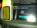
Proof of frozen hash @61.4235,23.8756
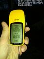
The proof. Nothing much here. The hash is about 5 m into the forest beyond the edge of the clearing. @61.4213,23.8777
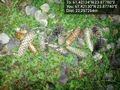
Cone marker left on the scene @61.4213,23.8774
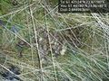
Mooses like power line clearings too. @61.4418,23.8618


Achievements
Teukkam earned the Land geohash achievement
|

TeukkaM earned the Sunrise Geohash Achievement
|