Difference between revisions of "2012-11-29 54 -3"
imported>Alexandersmith (→Plans) |
imported>FippeBot m (Location) |
||
| (9 intermediate revisions by one other user not shown) | |||
| Line 28: | Line 28: | ||
== Expedition == | == Expedition == | ||
| − | + | On arrival, I used the Android Geohashing app to find the location. That wasn't so easy because Birkrigg is home to lots of spiny, spiky gorse bushes. This made it difficult to use the "walk in straight lines until the hash is achieved" technique. There seemed to be no other geohashers on the common, just a few walkers looking slightly puzzled about the guy carrying his bike over gorse bushes. | |
| + | By the time I had found the hash, it was 16:17 and dusk was turning to night. I shot two photos and left. The air temperature had steadily decreased during the ride to about -3 Celcius, and I was starting to feel it. | ||
== Tracklog == | == Tracklog == | ||
| − | + | http://www.alxsmith.talktalk.net/xkcd/20121129.gpx | |
== Photos == | == Photos == | ||
| − | < | + | <gallery perrow="2"> |
| − | Image: | + | Image:20121129_GeohashAchieved.jpg | Droid Geohash app showing my proximity to the geohash point. |
| − | -- | + | Image:20121129_GeohashAutoPhoto.jpg | Auto-photo at the geo-hash. |
| − | |||
</gallery> | </gallery> | ||
== Achievements == | == Achievements == | ||
| − | {{ | + | {{bicycle geohash | latitude = 54 | longitude = -3 | date = 2012-11-29 | name = [[User:Alexandersmith|Alexandersmith]] | distance = 18 miles. | bothways = true }} |
| − | + | {{Land geohash | latitude = 54 | longitude = -3 | date = 2012-11-29 | name = [[User:Alexandersmith|Alexandersmith]]}} | |
| − | |||
| − | |||
| − | |||
| − | |||
| − | |||
| − | |||
| − | |||
| − | |||
| − | |||
| − | |||
| − | |||
[[Category:Expeditions]] | [[Category:Expeditions]] | ||
| − | |||
[[Category:Expeditions with photos]] | [[Category:Expeditions with photos]] | ||
| − | |||
| − | |||
| − | |||
| − | |||
| − | |||
[[Category:Coordinates reached]] | [[Category:Coordinates reached]] | ||
| − | + | {{location|GB|ENG|CMA}} | |
| − | |||
| − | |||
| − | |||
| − | |||
| − | |||
| − | |||
| − | |||
| − | |||
| − | |||
| − | |||
| − | |||
| − | |||
| − | |||
| − | |||
| − | |||
| − | |||
| − | |||
Latest revision as of 00:03, 14 August 2019
| Thu 29 Nov 2012 in 54,-3: 54.1625608, -3.0977453 geohashing.info google osm bing/os kml crox |
Location
Lower Birkrigg Common, near Ulverston.
Participants
Plans
My plan is to cycle there, as it's not too far from my home on Walney Island. The ride there was uneventful, and I arrived on Birkrigg near 4pm.
Expedition
On arrival, I used the Android Geohashing app to find the location. That wasn't so easy because Birkrigg is home to lots of spiny, spiky gorse bushes. This made it difficult to use the "walk in straight lines until the hash is achieved" technique. There seemed to be no other geohashers on the common, just a few walkers looking slightly puzzled about the guy carrying his bike over gorse bushes. By the time I had found the hash, it was 16:17 and dusk was turning to night. I shot two photos and left. The air temperature had steadily decreased during the ride to about -3 Celcius, and I was starting to feel it.
Tracklog
http://www.alxsmith.talktalk.net/xkcd/20121129.gpx
Photos
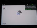
Droid Geohash app showing my proximity to the geohash point.
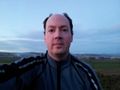
Auto-photo at the geo-hash.


Achievements
Alexandersmith earned the Bicycle geohash achievement
|
Alexandersmith earned the Land geohash achievement
|