Difference between revisions of "2012-12-02 56 13"
From Geohashing
imported>Llavids (Created page with "{{meetup graticule | lat=56 | lon=13 | date=2012-12-02 }} __NOTOC__ == Location == x, Hässleholm, Skåne, [[wikipedia:Sweden|Swe...") |
imported>Llavids (→Photos) |
||
| Line 22: | Line 22: | ||
Image:20121202-56-13-01-Proof.png|Proof | Image:20121202-56-13-01-Proof.png|Proof | ||
Image:20121202-56-13-02-Map.png|Map | Image:20121202-56-13-02-Map.png|Map | ||
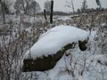
| − | Image:20121202-56-13-03-Cold.png| | + | Image:20121202-56-13-03-Cold.png|Frozen |
Image:20121202-56-13-04-The-grin.JPG|The grin | Image:20121202-56-13-04-The-grin.JPG|The grin | ||
Image:20121202-56-13-05-North.JPG|North | Image:20121202-56-13-05-North.JPG|North | ||
Revision as of 09:32, 14 December 2012
| Sun 2 Dec 2012 in 56,13: 56.2224845, 13.7114400 geohashing.info google osm bing/os kml crox |
Location
x, Hässleholm, Skåne, Sweden.
Participants
Plans
.
Expedition
.
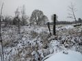
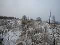
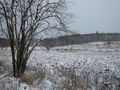
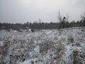
Photos
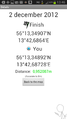
Proof
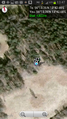
Map
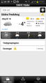
Frozen
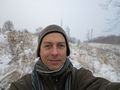
The grin
North
East
South
West
The geohash stone
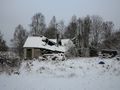
Nearest (abandoned) house


-house.JPG)
Achievements
Llavids earned the Land geohash achievement
|

Llavids earned the Frozen Geohash Achievement
by reaching the (56, 13) geohash on 2012-12-02 while the temperature was -5 °C.
Other Geohashing Expeditions and Plans on This Day
Expeditions and Plans
| 2012-12-02 | ||
|---|---|---|
| San Bernardino, California | LucasBrown | A mile west-northwest of Sunset Peak in the San Gabriel Mountains |
| Omaha West, Nebraska | Wsheldon67 | Somewhere |
| Hässleholm, Sweden | Llavids | Mala, Hässleholm, Skåne, Sweden. |