Difference between revisions of "2012-12-11 53 6"
imported>Eupeodes (another hash reached, so multihash) |
imported>FippeBot m (Location) |
||
| (5 intermediate revisions by one other user not shown) | |||
| Line 1: | Line 1: | ||
| − | |||
<!-- If you did not specify these parameters in the template, please substitute appropriate values for IMAGE, LAT, LON, and DATE (YYYY-MM-DD format) | <!-- If you did not specify these parameters in the template, please substitute appropriate values for IMAGE, LAT, LON, and DATE (YYYY-MM-DD format) | ||
| Line 18: | Line 17: | ||
__NOTOC__ | __NOTOC__ | ||
== Location == | == Location == | ||
| + | Appears to be on a small road or track. So should be easy | ||
<!-- where you've surveyed the hash to be --> | <!-- where you've surveyed the hash to be --> | ||
== Participants == | == Participants == | ||
| + | [[User:Eupeodes|Eupeodes]] | ||
<!-- who attended: If you link to your wiki user name in this section, your expedition will be picked up by the various statistics generated for geohashing. You may use three tildes ~ as a shortcut to automatically insert the user signature of the account you are editing with. | <!-- who attended: If you link to your wiki user name in this section, your expedition will be picked up by the various statistics generated for geohashing. You may use three tildes ~ as a shortcut to automatically insert the user signature of the account you are editing with. | ||
--> | --> | ||
== Plans == | == Plans == | ||
| + | First visit [[2012-12-11 52 5|52 5]], take the train to Assen and cycle to the hash. | ||
<!-- what were the original plans --> | <!-- what were the original plans --> | ||
== Expedition == | == Expedition == | ||
| − | + | First of all the transit in Amersfoort failed because it was to short so I was half an hour delayed. After this minor inconvenience I arrived in Assen. I set of on the folding-bike and as soon as I left Assen it started to snow. For a short moment I considered going back, but in stead I put on some safety glasses and continued. About one kilometer from the hash the roads became snowed over but it was doable to cycle on it. A few hundred meters further it became worse with mud. For some reason I did not think of leaving the bike and continue by foot so I dragged the bike with me. At some moment I lost the road and it became quite dark already. Somewhere there I saw some Roe deer, but they noticed me as well so I wasn't able to take a picture of them. But nice. Now the road stopped, but since there were no signs telling me I should stay on the road I continued in what appeared to be a field. Later on it more appeared to be some swamp. Again I considered to turn back, but only 300 meters, and I had to get out of he mud in some direction. Whit lot of effort I got some 150 meters from the hash, finding some puddle which did not seemed very inviting to cross so I turned right to get back to the road and decided to claim [[MNB_Geohash|MNB]]. After 25 meters I found something that looked like a road in the direction of the hash so decided to go for it again. At 50 meters I got stuck again, but giving up was not an option anymore since I got so close. After another 25 meters of dragging the bike with me I finally realized that I could leave it and just walk. I reached the hash, put a X in the snow on a cut of tree and took some pictures. Now of course I was faced with a new challenge. Get back to civilization. So after some more struggling I came back to a road. Because of all the mud and snow the wheels of the bike were completely blocked, so first I had to clean it out while it was almost dark. After this I walked the most slippery part before cycling back to the station. | |
| − | |||
| − | |||
| − | |||
== Photos == | == Photos == | ||
| − | |||
| − | |||
| − | |||
<gallery perrow="5"> | <gallery perrow="5"> | ||
| + | Image:2012-12-11_53_6_proof.JPG | Proof | ||
| + | Image:2012-12-11_53_6_grin.JPG | Grin? | ||
| + | Image:2012-12-11_53_6_marker.JPG | Marker I made | ||
| + | Image:2012-12-11_53_6_scene.JPG | Scene | ||
</gallery> | </gallery> | ||
== Achievements == | == Achievements == | ||
{{#vardefine:ribbonwidth|800px}} | {{#vardefine:ribbonwidth|800px}} | ||
| + | {{Multihash | ||
| + | | latitude1 = 52 | ||
| + | | longitude1 = 5 | ||
| + | | latitude2 = 53 | ||
| + | | longitude2 = 6 | ||
| + | | date = 2012-12-11 | ||
| + | | name = [[User:Eupeodes|Eupeodes]] | ||
| + | }} | ||
| + | {{Minesweeper geohash | ||
| + | | graticule = Utrecht, Netherlands | ||
| + | | ranknumber = 5 | ||
| + | | s = true | ||
| + | | w = true | ||
| + | | e = true | ||
| + | | sw = true | ||
| + | | ne = true | ||
| + | | name = [[User:Eupeodes|Eupeodes]] | ||
| + | }} | ||
| + | {{Minesweeper geohash | ||
| + | | graticule = Enschede, Netherlands | ||
| + | | ranknumber = 3 | ||
| + | | sw = true | ||
| + | | w=true | ||
| + | | n=true | ||
| + | | name = [[User:Eupeodes|Eupeodes]] | ||
| + | }} | ||
<!-- Add any achievement ribbons you earned below, or remove this section --> | <!-- Add any achievement ribbons you earned below, or remove this section --> | ||
| − | |||
| − | |||
| − | |||
| − | |||
| − | |||
| − | |||
| − | |||
| − | |||
| − | |||
| − | |||
| − | |||
[[Category:Expeditions]] | [[Category:Expeditions]] | ||
| − | |||
[[Category:Expeditions with photos]] | [[Category:Expeditions with photos]] | ||
| − | |||
| − | |||
| − | |||
| − | |||
| − | |||
[[Category:Coordinates reached]] | [[Category:Coordinates reached]] | ||
| − | + | [[Category:Eupeodes]] | |
| − | + | {{location|NL|DR}} | |
| − | |||
| − | [[Category: | ||
| − | |||
| − | |||
| − | |||
| − | |||
| − | |||
| − | |||
| − | |||
| − | |||
| − | |||
| − | |||
| − | |||
| − | |||
| − | |||
| − | |||
Latest revision as of 00:11, 14 August 2019
| Tue 11 Dec 2012 in 53,6: 53.0331054, 6.6461475 geohashing.info google osm bing/os kml crox |
Location
Appears to be on a small road or track. So should be easy
Participants
Plans
First visit 52 5, take the train to Assen and cycle to the hash.
Expedition
First of all the transit in Amersfoort failed because it was to short so I was half an hour delayed. After this minor inconvenience I arrived in Assen. I set of on the folding-bike and as soon as I left Assen it started to snow. For a short moment I considered going back, but in stead I put on some safety glasses and continued. About one kilometer from the hash the roads became snowed over but it was doable to cycle on it. A few hundred meters further it became worse with mud. For some reason I did not think of leaving the bike and continue by foot so I dragged the bike with me. At some moment I lost the road and it became quite dark already. Somewhere there I saw some Roe deer, but they noticed me as well so I wasn't able to take a picture of them. But nice. Now the road stopped, but since there were no signs telling me I should stay on the road I continued in what appeared to be a field. Later on it more appeared to be some swamp. Again I considered to turn back, but only 300 meters, and I had to get out of he mud in some direction. Whit lot of effort I got some 150 meters from the hash, finding some puddle which did not seemed very inviting to cross so I turned right to get back to the road and decided to claim MNB. After 25 meters I found something that looked like a road in the direction of the hash so decided to go for it again. At 50 meters I got stuck again, but giving up was not an option anymore since I got so close. After another 25 meters of dragging the bike with me I finally realized that I could leave it and just walk. I reached the hash, put a X in the snow on a cut of tree and took some pictures. Now of course I was faced with a new challenge. Get back to civilization. So after some more struggling I came back to a road. Because of all the mud and snow the wheels of the bike were completely blocked, so first I had to clean it out while it was almost dark. After this I walked the most slippery part before cycling back to the station.
Photos
Proof

Grin?
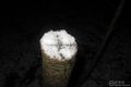
Marker I made
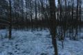
Scene


Achievements
Eupeodes earned the Multihash Achievement
|
Eupeodes achieved level 5 of the Minesweeper Geohash achievement
|
Eupeodes achieved level 3 of the Minesweeper Geohash achievement
|