Difference between revisions of "2012-12-24 48 -121"
imported>Thomcat ([live] Made it; stopped at Wendy's for snack on the road home.) |
imported>FippeBot m (Location) |
||
| (2 intermediate revisions by one other user not shown) | |||
| Line 1: | Line 1: | ||
| − | |||
| − | |||
| − | |||
| − | |||
| − | |||
| − | |||
| − | |||
| − | |||
| − | |||
| − | |||
{{meetup graticule | {{meetup graticule | ||
| lat=48 | | lat=48 | ||
| Line 15: | Line 5: | ||
}} | }} | ||
| − | |||
__NOTOC__ | __NOTOC__ | ||
== Location == | == Location == | ||
| − | + | An accessible forest road near Lake Cavanaugh | |
== Participants == | == Participants == | ||
| − | + | * [[User:Thomcat|Thomcat]] and daughter | |
| − | + | ||
| + | == Expedition == | ||
| + | Checking today's point, I see a potential early Christmas present. Time for geohash! | ||
| + | |||
| + | The road north was a piece of cake mid-day; I think a lot of people were off work. Arlington, then the Darington road, then hang a left on the Lake Cavanaugh access road. For a lake full of cabins, this access road was garbage - one small lane right off highway 530, then dirt most of the way up. Oh, sure, it's paved at the lake. | ||
| − | + | Anyhow, found the access road off North Shore drive easily - very melty around here. The level of the ground water / mosquito breeding grounds was right at the road level. The access road was narrow and filled with snow, so I parked and we walked. | |
| − | |||
| − | + | Convenient spray painted trees and stumps indicated half a mile and a mile; the turnoff road was at 1.2 miles (give or take) and was conveniently marked with snowmen. Just a little further up and the geohash was easily found. No internet signal (and geohash droid isn't so useful if it can't download maps), no way to post at the point, and my camera was having a heck of a time focusing on the screen. | |
| − | |||
| + | Walking down the road seemed a lot longer than up, and despite it being above freezing we were pretty chilled. Made it to the car, down the access road to the highway, and a quick stop on the way south. | ||
*Made it; stopped at Wendy's for snack on the road home. -- [[User:Thomcat|Thomcat]] [http://www.openstreetmap.org/?lat=48.15229945&lon=-122.18304313&zoom=16&layers=B000FTF @48.1523,-122.1830] 16:24, 24 December 2012 (PST) | *Made it; stopped at Wendy's for snack on the road home. -- [[User:Thomcat|Thomcat]] [http://www.openstreetmap.org/?lat=48.15229945&lon=-122.18304313&zoom=16&layers=B000FTF @48.1523,-122.1830] 16:24, 24 December 2012 (PST) | ||
| − | |||
| − | |||
== Photos == | == Photos == | ||
| Line 40: | Line 30: | ||
--> | --> | ||
<gallery perrow="5"> | <gallery perrow="5"> | ||
| + | Image:2012-12-24 48 -121 GettingCloser.jpg | No map, so measured in transit | ||
| + | Image:2012-12-24 48 -121 Snowman.jpg | A snowman up the road? | ||
| + | Image:2012-12-24 48 -121 SnowmanDetail1.jpg | ||
| + | Image:2012-12-24 48 -121 SnowmanDetail2.jpg | ||
| + | Image:2012-12-24 48 -121 OnTheSpot.jpg | No map, but GPS says we are there | ||
| + | Image:2012-12-24 48 -121 Geohasher.jpg | Success! | ||
| + | Image:2012-12-24 48 -121 Dragalong.jpg | Happy to be here | ||
| + | |||
</gallery> | </gallery> | ||
| Line 45: | Line 43: | ||
{{#vardefine:ribbonwidth|800px}} | {{#vardefine:ribbonwidth|800px}} | ||
<!-- Add any achievement ribbons you earned below, or remove this section --> | <!-- Add any achievement ribbons you earned below, or remove this section --> | ||
| + | Something about snowmen? | ||
| − | |||
| − | |||
| − | |||
| − | |||
| − | |||
| − | |||
| − | |||
| − | |||
| − | |||
| − | |||
| − | |||
[[Category:Expeditions]] | [[Category:Expeditions]] | ||
| − | |||
[[Category:Expeditions with photos]] | [[Category:Expeditions with photos]] | ||
| − | |||
| − | |||
| − | |||
| − | |||
| − | |||
[[Category:Coordinates reached]] | [[Category:Coordinates reached]] | ||
| − | + | {{location|US|WA|SG}} | |
| − | |||
| − | |||
| − | |||
| − | |||
| − | |||
| − | |||
| − | |||
| − | |||
| − | |||
| − | |||
| − | |||
| − | |||
| − | |||
| − | |||
| − | |||
| − | |||
| − | |||
Latest revision as of 00:24, 14 August 2019
| Mon 24 Dec 2012 in 48,-121: 48.3173934, -121.9685891 geohashing.info google osm bing/os kml crox |
Location
An accessible forest road near Lake Cavanaugh
Participants
- Thomcat and daughter
Expedition
Checking today's point, I see a potential early Christmas present. Time for geohash!
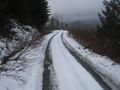
The road north was a piece of cake mid-day; I think a lot of people were off work. Arlington, then the Darington road, then hang a left on the Lake Cavanaugh access road. For a lake full of cabins, this access road was garbage - one small lane right off highway 530, then dirt most of the way up. Oh, sure, it's paved at the lake.
Anyhow, found the access road off North Shore drive easily - very melty around here. The level of the ground water / mosquito breeding grounds was right at the road level. The access road was narrow and filled with snow, so I parked and we walked.
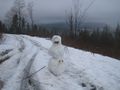
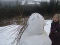
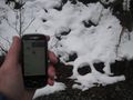
Convenient spray painted trees and stumps indicated half a mile and a mile; the turnoff road was at 1.2 miles (give or take) and was conveniently marked with snowmen. Just a little further up and the geohash was easily found. No internet signal (and geohash droid isn't so useful if it can't download maps), no way to post at the point, and my camera was having a heck of a time focusing on the screen.
Walking down the road seemed a lot longer than up, and despite it being above freezing we were pretty chilled. Made it to the car, down the access road to the highway, and a quick stop on the way south.
- Made it; stopped at Wendy's for snack on the road home. -- Thomcat @48.1523,-122.1830 16:24, 24 December 2012 (PST)
Photos
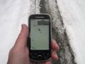
No map, so measured in transit
A snowman up the road?
No map, but GPS says we are there

Success!

Happy to be here


Achievements
Something about snowmen?