Difference between revisions of "2013-01-02 47 8"
imported>Chris 47 8 |
imported>FippeBot m (Location) |
||
| (9 intermediate revisions by 3 users not shown) | |||
| Line 7: | Line 7: | ||
__NOTOC__ | __NOTOC__ | ||
== Location == | == Location == | ||
| − | A forest near | + | A patch of forest near Steinen SZ. |
== Participants == | == Participants == | ||
| Line 13: | Line 13: | ||
== Plans == | == Plans == | ||
| − | + | My first Geohash. The plan: just go and see what's there! :) | |
| − | My first Geohash. The plan: just go and see | ||
== Expedition == | == Expedition == | ||
| + | A day off and nothing to do. While aimlessly surfing the internet, I came upon the geohashing website. A closer look at today's location reveals: It is only around 1km away from a train station. | ||
| + | The decision was done quickly: let's do it! | ||
| − | + | So I quickly downloaded a GPS-app for my iPhone, printed a map and jumped on the next train. Only 1,5 hours later I was there. I crossed the sleepy town of Steinen in the canton of Schwyz, went a bit uphill behind the village, and immediately found the place. Success! | |
| − | + | Unfortunately, there is only one train per hour back to Zurich, so I had to wait for 45 minutes at the train station at a temperature of around 5°C. During that time, one train after the other | |
| + | passed the train station, which lies on the [[wikipedia:Gotthard railway|Gotthard line]], | ||
| + | one of the major train routes to cross the Alps. | ||
| − | |||
== Photos == | == Photos == | ||
| − | |||
<gallery perrow="4"> | <gallery perrow="4"> | ||
Image:2013-01-02_47_8_00.JPG|Mount Rigi and Lake Zug. | Image:2013-01-02_47_8_00.JPG|Mount Rigi and Lake Zug. | ||
| Line 38: | Line 39: | ||
Image:2013-01-02_47_8_09.JPG|Sunset. | Image:2013-01-02_47_8_09.JPG|Sunset. | ||
Image:2013-01-02_47_8_10.JPG|Steinen train station. | Image:2013-01-02_47_8_10.JPG|Steinen train station. | ||
| − | |||
</gallery> | </gallery> | ||
== Achievements == | == Achievements == | ||
| + | {{Public transport geohash|latitude=47|longitude=8|date=2013-01-02|name=[[User:Chris_47_8|Chris_47_8]]}} | ||
| + | {{Land geohash|latitude=47|longitude=8|date=2013-01-02|name=[[User:Chris_47_8|Chris_47_8]]}} | ||
[[Category:Expeditions]] | [[Category:Expeditions]] | ||
[[Category:Expeditions with photos]] | [[Category:Expeditions with photos]] | ||
[[Category:Coordinates reached]] | [[Category:Coordinates reached]] | ||
| + | {{location|CH|SZ}} | ||
Latest revision as of 00:29, 14 August 2019
| Wed 2 Jan 2013 in 47,8: 47.0553940, 8.6168530 geohashing.info google osm bing/os kml crox |
Location
A patch of forest near Steinen SZ.
Participants
Plans
My first Geohash. The plan: just go and see what's there! :)
Expedition
A day off and nothing to do. While aimlessly surfing the internet, I came upon the geohashing website. A closer look at today's location reveals: It is only around 1km away from a train station. The decision was done quickly: let's do it!
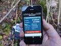
So I quickly downloaded a GPS-app for my iPhone, printed a map and jumped on the next train. Only 1,5 hours later I was there. I crossed the sleepy town of Steinen in the canton of Schwyz, went a bit uphill behind the village, and immediately found the place. Success!
Unfortunately, there is only one train per hour back to Zurich, so I had to wait for 45 minutes at the train station at a temperature of around 5°C. During that time, one train after the other passed the train station, which lies on the Gotthard line, one of the major train routes to cross the Alps.
Photos
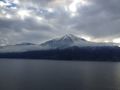
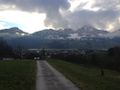
Mount Rigi and Lake Zug.
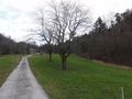
The last meters on a road: Make a 90° right turn here.
There it is.
I did it!
Second proof. In the background you see my backpack and the map.
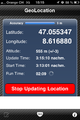
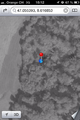
Screenshot
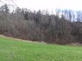
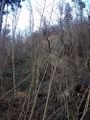
The area around the hash lies in steep terrain.
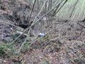
There was a landslide right above the hash just recently!
Nice view on the way back.
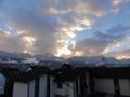
Sunset.
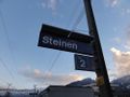
Steinen train station.


Achievements
Chris_47_8 earned the Public transport geohash achievement
|
Chris_47_8 earned the Land geohash achievement
|