Difference between revisions of "2013-01-08 60 24"
imported>Kmk ([live] At geohash.) |
imported>Vyznev (OK, did I get this more or less right?) |
||
| Line 1: | Line 1: | ||
| − | |||
<!-- If you did not specify these parameters in the template, please substitute appropriate values for IMAGE, LAT, LON, and DATE (YYYY-MM-DD format) | <!-- If you did not specify these parameters in the template, please substitute appropriate values for IMAGE, LAT, LON, and DATE (YYYY-MM-DD format) | ||
| Line 18: | Line 17: | ||
__NOTOC__ | __NOTOC__ | ||
== Location == | == Location == | ||
| − | + | On the corner of Nordenskiöldinkatu and Minna Canthin katu in Töölö, Helsinki. | |
== Participants == | == Participants == | ||
| − | + | * [[User:Kmk|Kmk]] | |
| − | + | * [[User:Vyznev|Vyznev]] | |
| − | |||
| − | |||
| − | |||
== Expedition == | == Expedition == | ||
<!-- how it all turned out. your narrative goes here. --> | <!-- how it all turned out. your narrative goes here. --> | ||
| + | *At geohash. -- [[User:Kmk|Kmk]] [http://www.openstreetmap.org/?lat=60.18677061&lon=24.91869062&zoom=16&layers=B000FTF @60.1868,24.9187] 05:39, 8 January 2013 (EST) | ||
| − | + | [[User:Vyznev|Vyznev]]: | |
| − | + | This was my first geohash ever. I just happened to look at the geohashing wiki before leaving work, and saw that the hashpoint was on a street corner in central Helsinki, only a short bus ride away. I don't have a GPS, so I just looked up the location on Google Maps and Street View and memorized it. | |
| − | + | ||
| + | After looking at the bus routes on the route planner, I also realized that I hadn't crossed my own path while coming to work, so I could attempt the [[Tron achievement]]. (As I understand it, stopping in a building and crossing my path while inside doesn't count.) I'd already walked right past the nearest bus stop, though, so I had to make a small detour through the woods to another stop. | ||
| + | |||
| + | Finding the actual hashpoint wasn't particularly difficult, even from memory. I looked for signs of any earlier visitors (didn't spot any), wrote "XKCD" in the snow and took some pictures. Didn't remember to make a [[Snowman Geohash|snowman]], though. On the way back, I took a tram to the city center, stopped to buy some groceries and took another bus home. For a final twist, I dozed off in the bus and ended up missing my stop. I wasn't sure if taking another bus back along the same road would be enough to disqualify me from the Tron achievement, so I decided to walk home along some small footpaths instead, which would've been quite pleasant if I hadn't been carrying a ridiculously heavy bag of groceries along. | ||
| + | |||
| + | I was hoping to get the [[Frozen Geohash]] achievement too, but I didn't have a thermometer with me, and the temperature recorded at the closest weather station at the time I visited the hashpoint was just around 0 °C, so I can't really be sure. | ||
== Photos == | == Photos == | ||
| Line 40: | Line 42: | ||
--> | --> | ||
<gallery perrow="5"> | <gallery perrow="5"> | ||
| + | File:GeoHash 2013-01-08 60 24 Google Street View screenshot 1.jpeg | Virtual view of the hashpoint from the northwest along Minna Canthin katu on Google Street View | ||
| + | File:GeoHash 2013-01-08 60 24 Google Street View screenshot 2.jpeg | Virtual view of the hashpoint from the south across the street crossing on Google Street View | ||
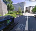
| + | File:GeoHash 2013-01-08 60 24 Google Street View screenshot 3.jpeg | Virtual view of the hashpoint from the northeast across Nordenskiöldinkatu on Google Street View | ||
| + | File:GeoHash 2013-01-08 60 24 photo 001.jpeg | Heading towards the hashpoint on bus 506 <!-- will add rest of photos later --> | ||
| + | File:GeoHash 2013-01-08 60 24 Google Earth route screenshot.png | Reconstructed route, demonstrating Tron achievement | ||
| + | File:GeoHash 2013-01-08 60 24 Foreca weather Kaisaniemi.png | Temperature peaked at just barely above 0 °C, so no frozen geohash | ||
</gallery> | </gallery> | ||
| Line 45: | Line 53: | ||
{{#vardefine:ribbonwidth|800px}} | {{#vardefine:ribbonwidth|800px}} | ||
<!-- Add any achievement ribbons you earned below, or remove this section --> | <!-- Add any achievement ribbons you earned below, or remove this section --> | ||
| + | {{Land geohash|latitude=60|longitude=24|date=2013-01-08|name=[[User:Vyznev|Vyznev]]}} | ||
| + | {{No batteries geohash|latitude=60|longitude=24|date=2013-01-08|name=[[User:Vyznev|Vyznev]]}} | ||
| + | {{Public transport geohash|latitude=60|longitude=24|date=2013-01-08|name=[[User:Vyznev|Vyznev]]}} | ||
| + | {{Tron|latitude=60|longitude=24|date=2013-01-08|name=[[User:Vyznev|Vyznev]]|possessive=his|tracklog={{fullurl:File:GeoHash_2013-01-08_60_24_Google_Earth_route_screenshot.png}}}} | ||
| + | |||
| Line 51: | Line 64: | ||
[[Category:New report]] | [[Category:New report]] | ||
| − | |||
| − | |||
| − | |||
| − | |||
| − | |||
| − | |||
[[Category:Expeditions]] | [[Category:Expeditions]] | ||
| − | + | <!-- | |
[[Category:Expeditions with photos]] | [[Category:Expeditions with photos]] | ||
[[Category:Expeditions with videos]] | [[Category:Expeditions with videos]] | ||
| + | --> | ||
[[Category:Expedition without GPS]] | [[Category:Expedition without GPS]] | ||
| − | |||
| − | |||
[[Category:Coordinates reached]] | [[Category:Coordinates reached]] | ||
| − | |||
| − | |||
| − | |||
| − | |||
| − | |||
| − | |||
| − | |||
| − | |||
| − | |||
| − | |||
| − | |||
| − | |||
| − | |||
| − | |||
| − | |||
| − | |||
| − | |||
| − | |||
Revision as of 12:38, 11 January 2013
| Tue 8 Jan 2013 in 60,24: 60.1867275, 24.9173304 geohashing.info google osm bing/os kml crox |
Location
On the corner of Nordenskiöldinkatu and Minna Canthin katu in Töölö, Helsinki.
Participants
Expedition
- At geohash. -- Kmk @60.1868,24.9187 05:39, 8 January 2013 (EST)
Vyznev: This was my first geohash ever. I just happened to look at the geohashing wiki before leaving work, and saw that the hashpoint was on a street corner in central Helsinki, only a short bus ride away. I don't have a GPS, so I just looked up the location on Google Maps and Street View and memorized it.
After looking at the bus routes on the route planner, I also realized that I hadn't crossed my own path while coming to work, so I could attempt the Tron achievement. (As I understand it, stopping in a building and crossing my path while inside doesn't count.) I'd already walked right past the nearest bus stop, though, so I had to make a small detour through the woods to another stop.
Finding the actual hashpoint wasn't particularly difficult, even from memory. I looked for signs of any earlier visitors (didn't spot any), wrote "XKCD" in the snow and took some pictures. Didn't remember to make a snowman, though. On the way back, I took a tram to the city center, stopped to buy some groceries and took another bus home. For a final twist, I dozed off in the bus and ended up missing my stop. I wasn't sure if taking another bus back along the same road would be enough to disqualify me from the Tron achievement, so I decided to walk home along some small footpaths instead, which would've been quite pleasant if I hadn't been carrying a ridiculously heavy bag of groceries along.
I was hoping to get the Frozen Geohash achievement too, but I didn't have a thermometer with me, and the temperature recorded at the closest weather station at the time I visited the hashpoint was just around 0 °C, so I can't really be sure.
Photos
Virtual view of the hashpoint from the northwest along Minna Canthin katu on Google Street View

Virtual view of the hashpoint from the south across the street crossing on Google Street View

Virtual view of the hashpoint from the northeast across Nordenskiöldinkatu on Google Street View
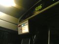
Heading towards the hashpoint on bus 506

Reconstructed route, demonstrating Tron achievement

Temperature peaked at just barely above 0 °C, so no frozen geohash


Achievements
Vyznev earned the Land geohash achievement
|
Vyznev earned the No Batteries Geohash Achievement
|
Vyznev earned the Public transport geohash achievement
|
Vyznev earned the Tron achievement
|