Difference between revisions of "2013-01-08 60 24"
imported>Kmk ([live] At geohash.) |
imported>FippeBot m (Location) |
||
| (3 intermediate revisions by 2 users not shown) | |||
| Line 1: | Line 1: | ||
| − | |||
| − | |||
| − | |||
| − | |||
| − | |||
| − | |||
| − | |||
| − | |||
| − | |||
| − | |||
{{meetup graticule | {{meetup graticule | ||
| lat=60 | | lat=60 | ||
| Line 14: | Line 4: | ||
| date=2013-01-08 | | date=2013-01-08 | ||
}} | }} | ||
| − | |||
| − | |||
__NOTOC__ | __NOTOC__ | ||
== Location == | == Location == | ||
| − | + | On the corner of Nordenskiöldinkatu and Minna Canthin katu in Töölö, Helsinki. | |
== Participants == | == Participants == | ||
| − | + | * [[User:Kmk|Kmk]] | |
| − | + | * [[User:Vyznev|Vyznev]] | |
| − | == | + | == Expedition == |
| − | + | *At geohash. -- [[User:Kmk|Kmk]] [http://www.openstreetmap.org/?lat=60.18677061&lon=24.91869062&zoom=16&layers=B000FTF @60.1868,24.9187] 05:39, 8 January 2013 (EST) | |
| + | |||
| + | [[User:Vyznev|Vyznev]]: | ||
| + | This was my first geohash ever. I just happened to look at the geohashing wiki before leaving work, and saw that the hashpoint was on a street corner in central Helsinki, only a short bus ride away. I don't have a GPS, so I just looked up the location on Google Maps and Street View and memorized it. | ||
| − | + | After looking at the bus routes on the route planner, I also realized that I hadn't crossed my own path while coming to work, so I could attempt the [[Tron achievement]]. (As I understand it, stopping in a building and crossing my path while inside doesn't count.) I'd already walked right past the nearest bus stop, though, so I had to make a small detour through the woods to another stop. | |
| − | |||
| + | Finding the actual hashpoint wasn't particularly difficult, even from memory. I looked for signs of any earlier visitors (didn't spot any), wrote "XKCD" in the snow and took some pictures. Didn't remember to make a [[Snowman Geohash|snowman]], though. On the way back, I took a tram to the city center, stopped to buy some groceries and took another bus home. For a final twist, I dozed off in the bus and ended up missing my stop. I wasn't sure if taking another bus back along the same road would be enough to disqualify me from the Tron achievement, so I decided to walk home along some small footpaths instead, which would've been quite pleasant if I hadn't been carrying a ridiculously heavy bag of groceries with me. | ||
| − | + | I was hoping to get the [[Frozen Geohash]] achievement too, but I didn't have a thermometer with me, and the temperature recorded at the closest weather station at the time I visited the hashpoint was just around 0 °C, so I can't really be sure. | |
| − | |||
| − | |||
== Photos == | == Photos == | ||
| − | < | + | <gallery> |
| − | + | File:GeoHash 2013-01-08 60 24 Google Street View screenshot 1.jpeg | Virtual view of the hashpoint from the northwest along Minna Canthin katu on Google Street View | |
| − | -- | + | File:GeoHash 2013-01-08 60 24 Google Street View screenshot 2.jpeg | Virtual view of the hashpoint from the south across the street crossing on Google Street View |
| − | + | File:GeoHash 2013-01-08 60 24 Google Street View screenshot 3.jpeg | Virtual view of the hashpoint from the northeast across Nordenskiöldinkatu on Google Street View | |
| + | File:GeoHash 2013-01-08 60 24 photo 001.jpeg | Heading towards the hashpoint on bus 506 | ||
| + | File:GeoHash 2013-01-08 60 24 photo 008.jpeg | Walked past this nice Czech pub on the way to the hashpoint | ||
| + | File:GeoHash 2013-01-08 60 24 photo 009.jpeg | Found the right street | ||
| + | File:GeoHash 2013-01-08 60 24 photo 014.jpeg | There it is! | ||
| + | File:GeoHash 2013-01-08 60 24 photo 018.jpeg | As far as I could determine from Google Maps, this "no parking" sign may have been situated just about on top of the hashpoint | ||
| + | File:GeoHash 2013-01-08 60 24 photo 025.jpeg | A view from the other side | ||
| + | File:GeoHash 2013-01-08 60 24 photo 026.jpeg | Left a mark in the snow for passers-by to wonder about | ||
| + | File:GeoHash 2013-01-08 60 24 photo 028.jpeg | The buildings next to the hashpoint are apparently a part of [[wikipedia:Alvar Aalto|Finnish architectural history]] | ||
| + | File:GeoHash 2013-01-08 60 24 photo 032.jpeg | Travel card reader in the tram, on the way from the hashpoint to the city center | ||
| + | File:GeoHash 2013-01-08 60 24 photo 036.jpeg | In bus 68, on the way back home | ||
| + | File:GeoHash 2013-01-08 60 24 Google Earth route screenshot.png | Reconstructed route, demonstrating Tron achievement | ||
| + | File:GeoHash 2013-01-08 60 24 Foreca weather Kaisaniemi.png | Temperature peaked at just barely above 0 °C, so no frozen geohash | ||
</gallery> | </gallery> | ||
== Achievements == | == Achievements == | ||
{{#vardefine:ribbonwidth|800px}} | {{#vardefine:ribbonwidth|800px}} | ||
| − | + | {{Land geohash|latitude=60|longitude=24|date=2013-01-08|name=[[User:Vyznev|Vyznev]]}} | |
| − | + | {{No batteries geohash|latitude=60|longitude=24|date=2013-01-08|name=[[User:Vyznev|Vyznev]]}} | |
| − | + | {{Public transport geohash|latitude=60|longitude=24|date=2013-01-08|name=[[User:Vyznev|Vyznev]]}} | |
| − | + | {{Tron|latitude=60|longitude=24|date=2013-01-08|name=[[User:Vyznev|Vyznev]]|possessive=his|tracklog={{fullurl:File:GeoHash_2013-01-08_60_24_Google_Earth_route_screenshot.png}}}} | |
| − | |||
| − | [[ | ||
| − | |||
| − | |||
| − | |||
| − | [[ | ||
| − | -- | ||
| − | |||
[[Category:Expeditions]] | [[Category:Expeditions]] | ||
| − | |||
[[Category:Expeditions with photos]] | [[Category:Expeditions with photos]] | ||
| − | |||
[[Category:Expedition without GPS]] | [[Category:Expedition without GPS]] | ||
| − | |||
| − | |||
| − | |||
[[Category:Coordinates reached]] | [[Category:Coordinates reached]] | ||
| − | + | {{location|FI|18}} | |
| − | |||
| − | |||
| − | |||
| − | |||
| − | |||
| − | |||
| − | |||
| − | |||
| − | |||
| − | |||
| − | |||
| − | |||
| − | |||
| − | |||
| − | |||
| − | |||
| − | |||
Latest revision as of 00:33, 14 August 2019
| Tue 8 Jan 2013 in 60,24: 60.1867275, 24.9173304 geohashing.info google osm bing/os kml crox |
Location
On the corner of Nordenskiöldinkatu and Minna Canthin katu in Töölö, Helsinki.
Participants
Expedition
- At geohash. -- Kmk @60.1868,24.9187 05:39, 8 January 2013 (EST)
Vyznev: This was my first geohash ever. I just happened to look at the geohashing wiki before leaving work, and saw that the hashpoint was on a street corner in central Helsinki, only a short bus ride away. I don't have a GPS, so I just looked up the location on Google Maps and Street View and memorized it.
After looking at the bus routes on the route planner, I also realized that I hadn't crossed my own path while coming to work, so I could attempt the Tron achievement. (As I understand it, stopping in a building and crossing my path while inside doesn't count.) I'd already walked right past the nearest bus stop, though, so I had to make a small detour through the woods to another stop.
Finding the actual hashpoint wasn't particularly difficult, even from memory. I looked for signs of any earlier visitors (didn't spot any), wrote "XKCD" in the snow and took some pictures. Didn't remember to make a snowman, though. On the way back, I took a tram to the city center, stopped to buy some groceries and took another bus home. For a final twist, I dozed off in the bus and ended up missing my stop. I wasn't sure if taking another bus back along the same road would be enough to disqualify me from the Tron achievement, so I decided to walk home along some small footpaths instead, which would've been quite pleasant if I hadn't been carrying a ridiculously heavy bag of groceries with me.
I was hoping to get the Frozen Geohash achievement too, but I didn't have a thermometer with me, and the temperature recorded at the closest weather station at the time I visited the hashpoint was just around 0 °C, so I can't really be sure.
Photos
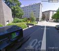
Virtual view of the hashpoint from the northwest along Minna Canthin katu on Google Street View
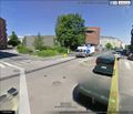
Virtual view of the hashpoint from the south across the street crossing on Google Street View
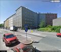
Virtual view of the hashpoint from the northeast across Nordenskiöldinkatu on Google Street View
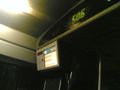
Heading towards the hashpoint on bus 506

Walked past this nice Czech pub on the way to the hashpoint
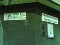
Found the right street
There it is!
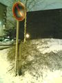
As far as I could determine from Google Maps, this "no parking" sign may have been situated just about on top of the hashpoint

A view from the other side
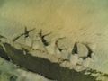
Left a mark in the snow for passers-by to wonder about
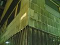
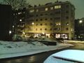
The buildings next to the hashpoint are apparently a part of Finnish architectural history
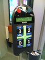
Travel card reader in the tram, on the way from the hashpoint to the city center
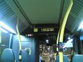
In bus 68, on the way back home
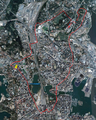
Reconstructed route, demonstrating Tron achievement
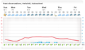
Temperature peaked at just barely above 0 °C, so no frozen geohash


Achievements
Vyznev earned the Land geohash achievement
|
Vyznev earned the No Batteries Geohash Achievement
|
Vyznev earned the Public transport geohash achievement
|
Vyznev earned the Tron achievement
|