Difference between revisions of "2013-01-09 -37 144"
imported>Lachie (→Expedition) |
m |
||
| (6 intermediate revisions by 4 users not shown) | |||
| Line 21: | Line 21: | ||
== Participants == | == Participants == | ||
* [[User:Lachie|Lachlan Gordon]] | * [[User:Lachie|Lachlan Gordon]] | ||
| − | * Cam | + | * [[User:Cam (2013)|Cam]] |
==Planning== | ==Planning== | ||
| Line 39: | Line 39: | ||
<gallery perrow="5"> | <gallery perrow="5"> | ||
| − | + | Image:2013-01-09 -37 144gps.png | GPS proof | |
| + | Image:IMG 02752013-01-09 -37 broady.jpg | Waiting for the train at Broadmeadows. | ||
| + | Image:IMG 02752013-01-09 -37 lachlancement.jpg | Lachlan driving a cement truck. | ||
| + | Image:IMG 02752013-01-09 -37 camcement.jpg | Cam in a cement truck. | ||
| + | Image:IMG 02752013-01-09 -37 dinner.jpg | Dinner on the train on the way home. | ||
| + | Image:IMG 02752013-01-09 -37 stout.JPG | Post Hash stout at Glenroy RSL. | ||
| + | Image:2013-01-09 -37 144 at the hash.JPG | Cam and Lachlan at the hash. | ||
</gallery> | </gallery> | ||
| Line 53: | Line 59: | ||
{{consecutive geohash | {{consecutive geohash | ||
| − | | count = | + | | count = 3 |
| latitude = -37 | | latitude = -37 | ||
| longitude = 145 | | longitude = 145 | ||
| date = 2013-01-07 | | date = 2013-01-07 | ||
| − | | name = [[User:Lachie|Lachlan Gordon]] | + | | name = Cam and [[User:Lachie|Lachlan Gordon]] |
}} | }} | ||
| Line 63: | Line 69: | ||
[[Category:Expeditions with photos]] | [[Category:Expeditions with photos]] | ||
[[Category:Coordinates reached]] | [[Category:Coordinates reached]] | ||
| + | {{location|AU|VIC|MC}} | ||
Latest revision as of 22:34, 20 May 2021
| Wed 9 Jan 2013 in -37,144: -37.2565571, 144.9330460 geohashing.info google osm bing/os kml crox |
Location
In a paddock West of Kilmore
Participants
Planning
After checking the geohash we decided kilmore was the best choice. The ride straight there from home was along freeways and wouldn't be very nice, our next preference for route was catching a train to Cragieburn and riding but this would take us very close to a bushfire which has since been contained. We decided on the train to Kilmore east and then ride the rest of the way,
Expedition
After a decent break from the previous expeditions(this is day three of Lachlan's five day consecutive) Lachlan and Cam continued their three day consecutive hash. Leaving Brunswick on bike at 6:20pm riding up the Upfield bike path and along camp road to Broadmeadows station. From there we caught the train to Kilmore East. The train arrived at Kilmore east station 20 minutes late meaning we had one hour to the planned return train or two hours for the train after. Being optimistic and naive we thought one hour for an 18k trip total would be plenty.
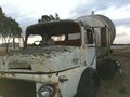
The first 6k were very easy but the final 2k of riding were on gravel, i was on a road bike with a history of broken spokes so we took it very slowly. As we turned off the first gravel road we noticed a dam in what looked like the direction of the hash but as we got closer discovered we were well clear, it had been a warm day so we weren't to worried about having to swim. Continuing down the road we found an abandoned cement truck and a lot of dead rabbits hanging from a fence(sorry forgot to take a photo). We reached a point where the bikes could take us no further, lying them down at the side of the road we climbed a fence and headed through a paddock to the hash point.
After the Hash we bought dinner supplies to eat on the way home and headed for the Kilmore Hotel which was unfortunately closed. Making it to the train with only a few minutes to spare(an hour after we had planned to get back) we caught the train back to Broadmeadows and road to what we thought would be the nearest open pub. Three closed pub's later we found the Glenroy RSL where we discussed the probability of winning the heads and tails lottery over a delicious stout.
Photos
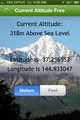
GPS proof
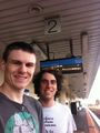
Waiting for the train at Broadmeadows.
Lachlan driving a cement truck.
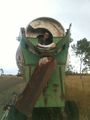
Cam in a cement truck.
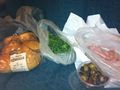
Dinner on the train on the way home.
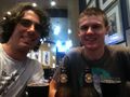
Post Hash stout at Glenroy RSL.
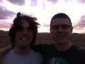
Cam and Lachlan at the hash.


Achievements
This is day 3 of a consecutive geohash achievement. For the other days, see:
- Day 1:
 2013-01-07 -37 145
 - Day 2: 2013-01-08 -38 145
- Day 3: 2013-01-09 -37 144
- Day 4: 2013-01-10 -37 145
- Day 5: 2013-01-11 -38 144
Cam and Lachlan Gordon earned the Consecutive geohash achievement
|