Difference between revisions of "2013-01-27 35 -82"
From Geohashing
imported>Spacenut |
imported>FippeBot m (Location) |
||
| (3 intermediate revisions by 2 users not shown) | |||
| Line 27: | Line 27: | ||
== Expedition == | == Expedition == | ||
| − | + | Well, it was pretty fun. Driving there took about 45 minutes, and then we spent about 10-20 minutes at the hash. Afterwards we stopped at a nearby visitor's center. | |
| − | |||
| − | |||
| − | |||
== Photos == | == Photos == | ||
<gallery perrow="5"> | <gallery perrow="5"> | ||
| − | Image:2013-01-27 35 -82 On Our Way. | + | Image:2013-01-27 35 -82 On Our Way.JPG | On our way |
| − | Image:2013-01-27 35 -82 Proof. | + | Image:2013-01-27 35 -82 Proof.JPG | Proof |
| − | Image:2013-01-27 35 -82 Photo of a Photo. | + | Image:2013-01-27 35 -82 Photo of a Photo.JPG | Photo-ception |
| − | Image:2013-01-27 35 -82 Stupid Grin. | + | Image:2013-01-27 35 -82 Stupid Grin.JPG | Stupid grin |
| − | Image:2013-01-27 35 -82 Juggling. | + | Image:2013-01-27 35 -82 Juggling.JPG | Juggling at the hash |
</gallery> | </gallery> | ||
== Achievements == | == Achievements == | ||
{{#vardefine:ribbonwidth|800px}} | {{#vardefine:ribbonwidth|800px}} | ||
| + | {{land geohash | ||
| + | | latitude = 35 | ||
| + | | longitude = -82 | ||
| + | | date = 2013-01-27 | ||
| + | | name = Spacenut | ||
| + | }} | ||
| + | {{Circus_geohash | ||
| + | | latitude = 35 | ||
| + | | longitude = -82 | ||
| + | | date = 2013-01-27 | ||
| + | | name = Spacenut | ||
| + | | performance = juggling | ||
| + | }} | ||
| − | <!-- =============== USEFUL CATEGORIES FOLLOW ================ | + | <!-- =============== USEFUL CATEGORIES FOLLOW ================ --> |
| − | |||
| − | |||
| − | |||
| − | |||
| − | |||
| − | |||
| − | |||
| − | |||
| − | |||
[[Category:Expeditions]] | [[Category:Expeditions]] | ||
| − | |||
[[Category:Expeditions with photos]] | [[Category:Expeditions with photos]] | ||
| − | |||
| − | |||
| − | |||
| − | |||
| − | |||
[[Category:Coordinates reached]] | [[Category:Coordinates reached]] | ||
| − | + | {{location|US|SC|PI}} | |
| − | |||
| − | |||
| − | |||
| − | |||
| − | |||
| − | |||
| − | |||
| − | |||
| − | |||
| − | |||
| − | |||
| − | |||
| − | |||
| − | |||
| − | |||
| − | |||
| − | |||
Latest revision as of 05:34, 6 August 2019
| Sun 27 Jan 2013 in 35,-82: 35.0019452, -82.7673281 geohashing.info google osm bing/os kml crox |
Location
Seems to be right off a dirt road. Should be easy to get to.
Participants
Plans
Going to drive down in the afternoon.
Expedition
Well, it was pretty fun. Driving there took about 45 minutes, and then we spent about 10-20 minutes at the hash. Afterwards we stopped at a nearby visitor's center.
Photos
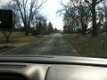
On our way
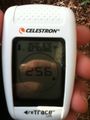
Proof
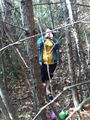
Photo-ception

Stupid grin

Juggling at the hash


Achievements
Spacenut earned the Land geohash achievement
|
Spacenut earned the Circus Geohash Achievement
|