Difference between revisions of "2013-02-03 32 -117"
From Geohashing
imported>LucasBrown (→Expedition) |
imported>FippeBot m (Location) |
||
| (6 intermediate revisions by 3 users not shown) | |||
| Line 1: | Line 1: | ||
| − | |||
| − | |||
| − | |||
| − | |||
| − | |||
| − | |||
| − | |||
| − | |||
| − | |||
| − | |||
{{meetup graticule | {{meetup graticule | ||
| lat=32 | | lat=32 | ||
| Line 15: | Line 5: | ||
}} | }} | ||
| − | |||
__NOTOC__ | __NOTOC__ | ||
== Location == | == Location == | ||
| Line 21: | Line 10: | ||
== Participants == | == Participants == | ||
| − | + | * [[User:JesseW|JesseW]] | |
| − | |||
== Plans == | == Plans == | ||
| − | + | Hoping to drive over around 3 PM with some friends. -- [[User:JesseW|JesseW]] 14:01, 3 February 2013 (EST) | |
== Expedition == | == Expedition == | ||
| − | + | [[User:JesseW|JesseW]]: It turned out that the friends were going to a Super Bowl party (that was about 1000 yards from the hashpoint), so they didn't make it, but me and my partner showed up (after dropping off the friends), at about 3:20 PM. A woman with a dog walked by as we were taking pictures, but otherwise no-one else was in sight. | |
| − | == | + | == Photos == |
| − | |||
| − | = | + | <gallery perrow="6"> |
| − | + | Image:2013-02-03 32 -117 1 Proof.jpg | Proof -- made it within 3 feet. | |
| − | Image: | + | Image:2013-02-03 32 -117 2 The spot -- north view.jpg | The spot -- north view. |
| − | -- | + | Image:2013-02-03 32 -117 3 The spot -- south view.jpg | And south view. |
| − | + | Image:2013-02-03 32 -117 4 The spot -- distance view.jpg | And a view from the distance. | |
| + | Image:2013-02-03 32 -117 5 Silly Grin.jpg | My Silly Grin. | ||
| + | Image:2013-02-03 32 -117 6 Palm tree.jpg | The rather tall palm tree pretty much right on the spot, as if marking it. | ||
</gallery> | </gallery> | ||
| Line 44: | Line 33: | ||
<!-- Add any achievement ribbons you earned below, or remove this section --> | <!-- Add any achievement ribbons you earned below, or remove this section --> | ||
| + | * Land Geohash | ||
| + | * Hashtree? | ||
| − | |||
| − | |||
| − | |||
| − | |||
| − | |||
| − | |||
| − | |||
| − | |||
| − | |||
| − | |||
[[Category:Expeditions]] | [[Category:Expeditions]] | ||
| − | |||
[[Category:Expeditions with photos]] | [[Category:Expeditions with photos]] | ||
| − | |||
| − | |||
| − | |||
| − | |||
| − | |||
[[Category:Coordinates reached]] | [[Category:Coordinates reached]] | ||
| − | + | {{location|US|CA|SD}} | |
| − | |||
| − | |||
| − | |||
| − | |||
| − | |||
| − | |||
| − | |||
| − | |||
| − | |||
| − | |||
| − | |||
| − | |||
| − | |||
| − | |||
| − | |||
| − | |||
| − | |||
Latest revision as of 00:53, 14 August 2019
| Sun 3 Feb 2013 in 32,-117: 32.8070823, -117.1332988 geohashing.info google osm bing/os kml crox |
Location
156.9 meters northwest of the 2012-10-09 hashpoint
Participants
Plans
Hoping to drive over around 3 PM with some friends. -- JesseW 14:01, 3 February 2013 (EST)
Expedition
JesseW: It turned out that the friends were going to a Super Bowl party (that was about 1000 yards from the hashpoint), so they didn't make it, but me and my partner showed up (after dropping off the friends), at about 3:20 PM. A woman with a dog walked by as we were taking pictures, but otherwise no-one else was in sight.
Photos
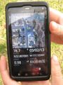
Proof -- made it within 3 feet.
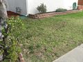
The spot -- north view.
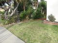
And south view.
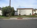
And a view from the distance.
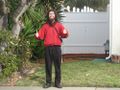
My Silly Grin.
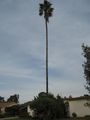
The rather tall palm tree pretty much right on the spot, as if marking it.


Achievements
- Land Geohash
- Hashtree?