Difference between revisions of "2013-02-03 51 0"
imported>PaintedJaguar (Creating expedition page) |
imported>FippeBot m (Location) |
||
| (4 intermediate revisions by one other user not shown) | |||
| Line 1: | Line 1: | ||
| − | |||
| − | |||
| − | |||
| − | |||
| − | |||
| − | |||
| − | |||
| − | |||
| − | |||
| − | |||
{{meetup graticule | {{meetup graticule | ||
| − | | lat= | + | | lat=51 |
| − | | lon= | + | | lon=0 |
| − | | date= | + | | date=2013-02-03 |
}} | }} | ||
| − | |||
__NOTOC__ | __NOTOC__ | ||
== Location == | == Location == | ||
| − | + | Outside a house on High Wych Road, near the town of Sawbridgeworth. | |
== Participants == | == Participants == | ||
| − | + | * [[User:PaintedJaguar|PaintedJaguar]] | |
| − | + | * MrsPaintedJaguar | |
| − | |||
== Plans == | == Plans == | ||
| − | + | The plans were to get a train from Cambridge to Sawbridgeworth shortly after we managed to get out of bed in the morning, walk to the hashpoint via the river, and then head back into Sawbridgeworth for a pub lunch. | |
== Expedition == | == Expedition == | ||
| − | + | The expedition went pretty much as planned, if perhaps a little later in the day than we originally hoped for, initially travelling on the 11:32 train from Cambridge to Sawbridgeworth (which was still just in the morning...). We had a very nice walk along the River Stort and then through a park that we subsequently discovered was called Pishiobury Park ([http://www.hertslink.org/cms/getactive/placestovisit/pishiobury/ offical website]) ([http://www.friendsofpishioburypark.co.uk/ 'Friends of...' website]). There were a few bits of the park that had more mud than grass, but that probably wasn't unexpected given the time of year! It's definitely a place we'd up for visiting again in the summer. | |
| + | |||
| + | From here, it wasn't very far at all to reach the hashpoint. We suspected that the exact hashpoint was in somebody's front garden, but when standing on the pavement outside their driveway, the GPS said we were 5 metres away, with an accuracy of 6 metres. That was good enough for us - we didn't fancy our chances asking the people who lived there for permission to walk all over their nicely kept lawn with our incredibly muddy boots! | ||
| + | |||
| + | It was now 1:30pm, and we were getting quite hungry, so we quickly headed directly into Sawbridgeworth town centre, where we found an excellent pub called [http://www.thegatepub.com/ The Gate], which had a fine selection of beers and did a delicious Sunday lunch. A short wander around the town centre followed, where we saw another couple of pubs that looked very nice, before we headed back to the train station for the journey back to Cambridge. | ||
| + | |||
| + | The overall summary was that this was an excellent day out, and Sawbridgeworth is now definitely on the map as somewhere we should visit in the future - for both walking and drinking! | ||
== Tracklog == | == Tracklog == | ||
| − | + | http://en.wikiloc.com/wikiloc/view.do?id=3969806 shows the route from Sawbridgeworth station, via the hashpoint, to the pub. | |
== Photos == | == Photos == | ||
| − | |||
| − | |||
| − | |||
<gallery perrow="5"> | <gallery perrow="5"> | ||
| + | Image:2013-02-03_51_0_boats.JPG | Boats on the river | ||
| + | Image:2013-02-03_51_0_swan1.JPG | Swan | ||
| + | Image:2013-02-03_51_0_swan2.JPG | Swan close-up | ||
| + | Image:2013-02-03_51_0_swan3.JPG | Swan | ||
| + | Image:2013-02-03_51_0_river.JPG | River Stort | ||
| + | Image:2013-02-03_51_0_muddy_path.JPG | Muddy ground | ||
| + | Image:2013-02-03_51_0_tree1.JPG | MrsPaintedJaguar in a tree | ||
| + | Image:2013-02-03_51_0_tree2.JPG | PaintedJaguar in a tree | ||
| + | Image:2013-02-03_51_0_park1.JPG | Pishiobury Park | ||
| + | Image:2013-02-03_51_0_park2.JPG | Pishiobury Park | ||
| + | Image:2013-02-03_51_0_bird1.JPG | Bird in flight | ||
| + | Image:2013-02-03_51_0_bird2.JPG | Bird in bushes | ||
| + | Image:2013-02-03_51_0_road_sign.JPG | Road sign, in need of some TLC | ||
| + | Image:2013-02-03_51_0_thatched_roof.JPG | Thatched roof barn, very close to hashpoint | ||
| + | Image:2013-02-03_51_0_tree_wall.JPG | Tree growing through a wall, very close to hashpoint | ||
| + | Image:2013-02-03_51_0_house.JPG | The hash-house | ||
| + | Image:2013-02-03_51_0_gps.JPG | GPS receiver, outside the hash-house | ||
| + | Image:2013-02-03_51_0_marker.JPG | Chalk message left on the pavement, with Hammersmith the Hashscot. I didn't almost get the year wrong, honest! | ||
| + | Image:2013-02-03_51_0_grin.JPG | Silly grins | ||
| + | Image:2013-02-03_51_0_clock_house.JPG | On the way to the pub: I wonder how it got it's name...? | ||
| + | Image:2013-02-03_51_0_pub.JPG | The Gate pub | ||
| + | Image:2013-02-03_51_0_pub_sign.JPG | Pub sign | ||
| + | Image:2013-02-03_51_0_tickets.JPG | Proof of public transport geohash | ||
</gallery> | </gallery> | ||
== Achievements == | == Achievements == | ||
{{#vardefine:ribbonwidth|800px}} | {{#vardefine:ribbonwidth|800px}} | ||
| − | |||
| + | {{land geohash | ||
| + | | latitude = 51 | ||
| + | | longitude = 0 | ||
| + | | date = 2013-02-03 | ||
| + | | name = PaintedJaguar | ||
| + | }} | ||
| + | |||
| + | {{Public transport geohash | ||
| + | | latitude = 51 | ||
| + | | longitude = 0 | ||
| + | | date = 2013-02-03 | ||
| + | | busline = the train | ||
| + | | name = PaintedJaguar | ||
| + | | image = 2013-02-03_51_0_tickets.JPG | ||
| + | }} | ||
| + | |||
| + | {{Minesweeper geohash | ||
| + | | graticule = Cambridge, United Kingdom | ||
| + | | ranknumber = 2 | ||
| + | | s = true | sw = true | ||
| + | | name = PaintedJaguar | ||
| + | }} | ||
| − | |||
| − | |||
| − | |||
| − | |||
| − | |||
| − | |||
| − | |||
| − | |||
[[Category:Expeditions]] | [[Category:Expeditions]] | ||
| − | |||
[[Category:Expeditions with photos]] | [[Category:Expeditions with photos]] | ||
| − | |||
| − | |||
| − | |||
| − | |||
| − | |||
[[Category:Coordinates reached]] | [[Category:Coordinates reached]] | ||
| − | + | {{location|GB|ENG|HRT}} | |
| − | |||
| − | |||
| − | |||
| − | |||
| − | |||
| − | |||
| − | |||
| − | |||
| − | |||
| − | |||
| − | |||
| − | |||
| − | |||
| − | |||
| − | |||
| − | |||
| − | |||
Latest revision as of 00:53, 14 August 2019
| Sun 3 Feb 2013 in 51,0: 51.8070823, 0.1332988 geohashing.info google osm bing/os kml crox |
Location
Outside a house on High Wych Road, near the town of Sawbridgeworth.
Participants
- PaintedJaguar
- MrsPaintedJaguar
Plans
The plans were to get a train from Cambridge to Sawbridgeworth shortly after we managed to get out of bed in the morning, walk to the hashpoint via the river, and then head back into Sawbridgeworth for a pub lunch.
Expedition
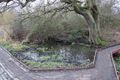
The expedition went pretty much as planned, if perhaps a little later in the day than we originally hoped for, initially travelling on the 11:32 train from Cambridge to Sawbridgeworth (which was still just in the morning...). We had a very nice walk along the River Stort and then through a park that we subsequently discovered was called Pishiobury Park (offical website) ('Friends of...' website). There were a few bits of the park that had more mud than grass, but that probably wasn't unexpected given the time of year! It's definitely a place we'd up for visiting again in the summer.
From here, it wasn't very far at all to reach the hashpoint. We suspected that the exact hashpoint was in somebody's front garden, but when standing on the pavement outside their driveway, the GPS said we were 5 metres away, with an accuracy of 6 metres. That was good enough for us - we didn't fancy our chances asking the people who lived there for permission to walk all over their nicely kept lawn with our incredibly muddy boots!
It was now 1:30pm, and we were getting quite hungry, so we quickly headed directly into Sawbridgeworth town centre, where we found an excellent pub called The Gate, which had a fine selection of beers and did a delicious Sunday lunch. A short wander around the town centre followed, where we saw another couple of pubs that looked very nice, before we headed back to the train station for the journey back to Cambridge.
The overall summary was that this was an excellent day out, and Sawbridgeworth is now definitely on the map as somewhere we should visit in the future - for both walking and drinking!
Tracklog
http://en.wikiloc.com/wikiloc/view.do?id=3969806 shows the route from Sawbridgeworth station, via the hashpoint, to the pub.
Photos
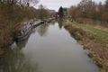
Boats on the river
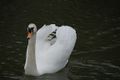
Swan
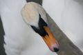
Swan close-up

Swan
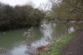
River Stort
Muddy ground
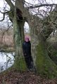
MrsPaintedJaguar in a tree
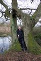
PaintedJaguar in a tree
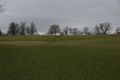
Pishiobury Park
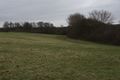
Pishiobury Park
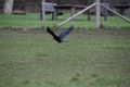
Bird in flight
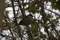
Bird in bushes
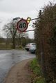
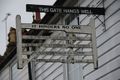
Road sign, in need of some TLC
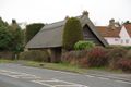
Thatched roof barn, very close to hashpoint
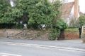
Tree growing through a wall, very close to hashpoint
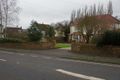
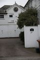
The hash-house
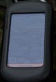
GPS receiver, outside the hash-house
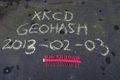
Chalk message left on the pavement, with Hammersmith the Hashscot. I didn't almost get the year wrong, honest!

Silly grins
On the way to the pub: I wonder how it got it's name...?
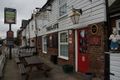
The Gate pub
Pub sign
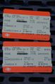
Proof of public transport geohash


Achievements
PaintedJaguar earned the Land geohash achievement
|
PaintedJaguar earned the Public transport geohash achievement
|
PaintedJaguar achieved level 2 of the Minesweeper Geohash achievement
|