Difference between revisions of "2013-02-06 32 -116"
imported>Mathgeek (→Plans) |
imported>FippeBot m (Location) |
||
| (11 intermediate revisions by 2 users not shown) | |||
| Line 1: | Line 1: | ||
| + | {{meetup graticule | lat=32 | lon=-116 | date=2013-02-06}} | ||
| − | |||
| − | |||
| − | |||
| − | |||
| − | |||
| − | |||
| − | |||
| − | |||
| − | |||
| − | |||
| − | |||
| − | |||
| − | |||
| − | |||
| − | |||
| − | |||
__NOTOC__ | __NOTOC__ | ||
== Location == | == Location == | ||
| − | + | In a valley off the end of Garden Road in Poway, CA | |
== Participants == | == Participants == | ||
| − | + | [[User:LucasBrown|LucasBrown]] reached the hashpoint at 11:36 (PST) | |
| − | |||
== Plans == | == Plans == | ||
| − | |||
| − | |||
*Hmmm... can I squeeze in a hike today? -- [[User:Mathgeek|Mathgeek]] 08:37, 6 February 2013 (PST) | *Hmmm... can I squeeze in a hike today? -- [[User:Mathgeek|Mathgeek]] 08:37, 6 February 2013 (PST) | ||
== Expedition == | == Expedition == | ||
| − | < | + | [[User:LucasBrown|LucasBrown]]'s expedition:<br> |
| + | I drove to the end of Hidden Valley Drive and proceeded by foot along a path roughly following the bottom of the valley. After a few hundred meters, both the valley and the path split, and I followed the southerly path to the hashpoint. The path quickly climbed a dozen meters or so while the bottom of the valley took a gentler slope, leading me about ten meters above the valley bottom. This path quickly led me to a spot about 17 meters from the hashpoint. The satellite imagery showed a rougher trail that would lead me to within a few meters of the hashpoint meeting the present trail obliquely a little ways further up the valley, so I proceeded to find this junction. This new, rougher trail was significantly less well-defined than the present trail, leading me to overshoot the merger. After backtracking a ways, I found the junction. This new trail led me to within five meters of the hashpoint, and after some pushing-aside of brush, the hashpoint was acquired. | ||
== Tracklog == | == Tracklog == | ||
| − | |||
== Photos == | == Photos == | ||
| − | |||
| − | |||
| − | |||
<gallery perrow="5"> | <gallery perrow="5"> | ||
| + | Image:2013-02-06_32_-116_16-24-59-052.jpg | Geohash Droid details page at the hashpoint | ||
| + | Image:2013-02-06_32_-116_16-26-12-804.jpg | Map at the hashpoint | ||
| + | Image:2013-02-06_32_-116_16-32-49-490.jpg | Close-up map at the hashpoint showing the paths in its immediate vicinity | ||
| + | Image:2013-02-06_32_-116_16-27-03-424.jpg | Terrain in the vicinity of the hashpoint | ||
| + | Image:2013-02-06_32_-116_16-28-22-099.jpg | The hashpoint is atop this boulder. | ||
</gallery> | </gallery> | ||
== Achievements == | == Achievements == | ||
{{#vardefine:ribbonwidth|800px}} | {{#vardefine:ribbonwidth|800px}} | ||
| − | |||
| − | |||
| − | |||
| − | |||
| − | |||
| − | |||
| − | |||
| − | |||
| − | |||
| − | |||
| − | |||
| − | |||
[[Category:Expeditions]] | [[Category:Expeditions]] | ||
| − | |||
[[Category:Expeditions with photos]] | [[Category:Expeditions with photos]] | ||
| − | |||
[[Category:Expedition without GPS]] | [[Category:Expedition without GPS]] | ||
| − | |||
| − | |||
| − | |||
[[Category:Coordinates reached]] | [[Category:Coordinates reached]] | ||
| − | + | {{location|US|CA|SD}} | |
| − | |||
| − | |||
| − | |||
| − | |||
| − | |||
| − | |||
| − | |||
| − | |||
| − | |||
| − | |||
| − | |||
| − | |||
| − | |||
| − | |||
| − | |||
| − | |||
| − | |||
Latest revision as of 00:54, 14 August 2019
| Wed 6 Feb 2013 in 32,-116: 32.9621627, -116.9879704 geohashing.info google osm bing/os kml crox |
Location
In a valley off the end of Garden Road in Poway, CA
Participants
LucasBrown reached the hashpoint at 11:36 (PST)
Plans
- Hmmm... can I squeeze in a hike today? -- Mathgeek 08:37, 6 February 2013 (PST)
Expedition
LucasBrown's expedition:
I drove to the end of Hidden Valley Drive and proceeded by foot along a path roughly following the bottom of the valley. After a few hundred meters, both the valley and the path split, and I followed the southerly path to the hashpoint. The path quickly climbed a dozen meters or so while the bottom of the valley took a gentler slope, leading me about ten meters above the valley bottom. This path quickly led me to a spot about 17 meters from the hashpoint. The satellite imagery showed a rougher trail that would lead me to within a few meters of the hashpoint meeting the present trail obliquely a little ways further up the valley, so I proceeded to find this junction. This new, rougher trail was significantly less well-defined than the present trail, leading me to overshoot the merger. After backtracking a ways, I found the junction. This new trail led me to within five meters of the hashpoint, and after some pushing-aside of brush, the hashpoint was acquired.
Tracklog
Photos
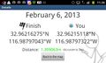
Geohash Droid details page at the hashpoint
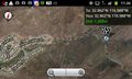
Map at the hashpoint
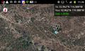
Close-up map at the hashpoint showing the paths in its immediate vicinity
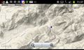
Terrain in the vicinity of the hashpoint
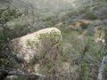
The hashpoint is atop this boulder.


