Difference between revisions of "2013-02-12 40 -74"
imported>Jevanyn (Inbound train passes in other direction, probably a Northeast Corridor train. I-78 overhead to the right. [http://www.openstreetmap.org/?lat=40.72340000&lon=-74.17110000&zoom=16&layers=B000FTF @40.7234,-74.1711]) |
imported>Jevanyn |
||
| Line 20: | Line 20: | ||
== Participants == | == Participants == | ||
| − | [[User:Jevanyn|Jevanyn]] | + | [[User:Jevanyn|Jevanyn]], along with about a thousand unknowing commuters. |
== Plans == | == Plans == | ||
| Line 28: | Line 28: | ||
*Well, there is no way to get into the prison (I'm not Batman), but I should have line of sight from the train on my commute home. I'll be within a mile to the west. (Closer train tracks are freight.) -- [[User:Jevanyn|Jevanyn]] 10:24, 12 February 2013 (EST) | *Well, there is no way to get into the prison (I'm not Batman), but I should have line of sight from the train on my commute home. I'll be within a mile to the west. (Closer train tracks are freight.) -- [[User:Jevanyn|Jevanyn]] 10:24, 12 February 2013 (EST) | ||
| + | Granted, I didn't go anywhere I wouldn't have normally been, but I did attempt to get a photograph of the area of the geohash, so there was a geohashing effort. Lame, I know, but it was interesting in as much as the geohash was 1) in the city where I was, and for which the graticule is named, and 2) it was close enough to my regularly traveled route, that I could potentially achieve line-of-sight to the "campus". | ||
== Tracklog == | == Tracklog == | ||
| Line 50: | Line 51: | ||
| − | |||
| − | |||
| − | |||
[[Category:Expeditions]] | [[Category:Expeditions]] | ||
| − | |||
[[Category:Expeditions with photos]] | [[Category:Expeditions with photos]] | ||
| − | |||
| − | |||
| − | |||
| − | |||
| − | |||
| − | |||
| − | |||
| − | |||
| − | |||
| − | |||
| − | |||
| − | |||
| − | |||
| − | |||
| − | |||
| − | |||
| − | |||
| − | |||
| − | |||
| − | |||
| − | |||
[[Category:Not reached - Did not attempt]] | [[Category:Not reached - Did not attempt]] | ||
| − | |||
| − | |||
[[Category:Not reached - No public access]] | [[Category:Not reached - No public access]] | ||
Revision as of 14:36, 13 February 2013
| Tue 12 Feb 2013 in 40,-74: 40.7125549, -74.1717823 geohashing.info google osm bing/os kml crox |
Location
Northern State Prison, Ironbound, Newark. Across I-78 from Newark Liberty Airport.
Participants
Jevanyn, along with about a thousand unknowing commuters.
Plans
Jevanyn will attempt to get a picture from the train. (Geohash itself is inaccessible.)
Expedition
- Well, there is no way to get into the prison (I'm not Batman), but I should have line of sight from the train on my commute home. I'll be within a mile to the west. (Closer train tracks are freight.) -- Jevanyn 10:24, 12 February 2013 (EST)
Granted, I didn't go anywhere I wouldn't have normally been, but I did attempt to get a photograph of the area of the geohash, so there was a geohashing effort. Lame, I know, but it was interesting in as much as the geohash was 1) in the city where I was, and for which the graticule is named, and 2) it was close enough to my regularly traveled route, that I could potentially achieve line-of-sight to the "campus".
Tracklog
My "track" will be the Raritan Valley Line, thank you :-)
Photos
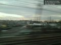
Looking eastward in the direction of the prison. @40.7234,-74.1711
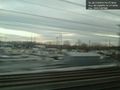
Second picture, a bit closer. @40.7234,-74.1711
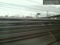
Inbound train passes in other direction, probably a Northeast Corridor train. I-78 overhead to the right. @40.7234,-74.1711


