Difference between revisions of "2013-02-16 41 -87"
imported>Zhukant ((he just changed his preferences, I thought I'd help him out here)) |
imported>FippeBot m (Location) |
||
| (3 intermediate revisions by one other user not shown) | |||
| Line 1: | Line 1: | ||
| − | + | [[Image:{{{image|2013-02-16 41 -87 zhukant on hash.jpg}}}|thumb|left|[[User:Zhukant|zhukant]] on the hash]] | |
| − | + | <!-- And DON'T FORGET to add your expedition and the best photo you took to the gallery on the Main Page! We'd love to read your report, but that means we first have to discover it! :) | |
| − | |||
| − | |||
| − | |||
| − | |||
| − | And DON'T FORGET to add your expedition and the best photo you took to the gallery on the Main Page! We'd love to read your report, but that means we first have to discover it! :) | ||
--> | --> | ||
{{meetup graticule | {{meetup graticule | ||
| Line 13: | Line 8: | ||
| date=2013-02-16 | | date=2013-02-16 | ||
}} | }} | ||
| + | __NOTOC__ | ||
| − | + | This '''Saturday, Feb 16, 2013''' [[Chicago]] geohash was successfully reached by two geohashers without incident. | |
| − | |||
| − | |||
== Location == | == Location == | ||
On the [http://en.wikipedia.org/wiki/Road_verge Road Verge] at the intersection of W Foster Ave and N Oleander Ave at the southern end of the Oriole Park neighborhood of northern Chicago. | On the [http://en.wikipedia.org/wiki/Road_verge Road Verge] at the intersection of W Foster Ave and N Oleander Ave at the southern end of the Oriole Park neighborhood of northern Chicago. | ||
| Line 26: | Line 20: | ||
== Plans == | == Plans == | ||
| − | '''zhukant''' and '''lrbrink90''' are | + | '''zhukant''' and '''lrbrink90''' are planned to drive there from Hyde Park to attend the official 4 PM Saturday meetup. |
== Expedition == | == Expedition == | ||
| − | + | This is our first successful hash ever, for both of us! | |
| + | |||
| + | We set out at around 3:10 after grabbing a couple of Subway sandwiches to eat at the hash while waiting for anybody else to show up. The traffic near downtown Chicago and all along I-90 was pretty awful, so even with 20 minutes to spare as per the GPS map app, we still got there about 5 minutes late. It was extremely chilly, so we quickly took the several photos of the hash (we decided to have a trademark rainbow umbrella as our hashing shtick) and hopped back into the car to eat our sandwiches and wait for any other people to show up. After finishing the sandwiches at around 4:30, we hopped out again to stand on the hash and appreciate the cosmic significance of finding this random dot inside a giant square, and how it is the only dot in that square that is so special. | ||
| + | |||
| + | We then drove to Oriole Park to see the namesake of the Oriole Park neighborhood of Chicago, but unfortunately it failed to impress. Ironically, right after that we ran across a fairly impressive-looking library for such a nondescript suburb of Chicago. We ducked inside and found this brilliant aquarium, so we just had to take a picture. | ||
| − | + | After this, we went to a local coffee shop which I recommend - Regulus Coffee House. Then we actually decided to attempt a GeoCache while we were there but we weren't that successful; it was getting dark and miserably cold (about 17 F by this point), so we headed home. | |
| − | |||
== Photos == | == Photos == | ||
| Line 39: | Line 36: | ||
--> | --> | ||
<gallery perrow="5"> | <gallery perrow="5"> | ||
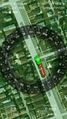
| + | Image:2013-02-16 41 -87 GPS Screenshot.jpg | Coordinates, date & time at the top, distance at the bottom | ||
| + | Image:2013-02-16 41 -87 lrbrink90 on hash.jpg | lrbrink90 with the umbrella. You can see the ground better in this one which matches up with the Google Maps spot. | ||
| + | Image:2013-02-16 41 -87 Oriole Park.jpg | The unimpressive Oriole Park | ||
| + | Image:2013-02-16 41 -87 Nearby Library.jpg | The impressive library | ||
| + | Image:2013-02-16 41 -87 Aquarium in Library.jpg | The aquarium in the library | ||
</gallery> | </gallery> | ||
| − | == Achievements == | + | ==Achievements== |
| − | {{ | + | {{drag-along |
| − | + | | latitude = 41 | |
| + | | longitude = -87 | ||
| + | | date = 2013-02-16 | ||
| + | | partner = [[User:lrbrink90|lrbrink90]] | ||
| + | | name = zhukant | ||
| + | }} | ||
| + | {{land geohash | ||
| + | | latitude = 41 | ||
| + | | longitude = -87 | ||
| + | | date = 2013-02-16 | ||
| + | | name = zhukant and lrbrink90 | ||
| + | }} | ||
| − | |||
| − | |||
| − | |||
| − | |||
| − | |||
| − | |||
| − | |||
| − | |||
| − | |||
| − | |||
[[Category:Expeditions]] | [[Category:Expeditions]] | ||
| − | |||
[[Category:Expeditions with photos]] | [[Category:Expeditions with photos]] | ||
| − | |||
| − | |||
| − | |||
| − | |||
| − | |||
[[Category:Coordinates reached]] | [[Category:Coordinates reached]] | ||
| − | + | {{location|US|IL|CO}} | |
| − | |||
| − | |||
| − | |||
| − | |||
| − | |||
| − | |||
| − | |||
| − | |||
| − | |||
| − | |||
| − | |||
| − | |||
| − | |||
| − | |||
| − | |||
| − | |||
| − | |||
Latest revision as of 00:59, 14 August 2019

| Sat 16 Feb 2013 in 41,-87: 41.9742546, -87.8157084 geohashing.info google osm bing/os kml crox |
This Saturday, Feb 16, 2013 Chicago geohash was successfully reached by two geohashers without incident.
Location
On the Road Verge at the intersection of W Foster Ave and N Oleander Ave at the southern end of the Oriole Park neighborhood of northern Chicago.
Participants
Plans
zhukant and lrbrink90 are planned to drive there from Hyde Park to attend the official 4 PM Saturday meetup.
Expedition
This is our first successful hash ever, for both of us!
We set out at around 3:10 after grabbing a couple of Subway sandwiches to eat at the hash while waiting for anybody else to show up. The traffic near downtown Chicago and all along I-90 was pretty awful, so even with 20 minutes to spare as per the GPS map app, we still got there about 5 minutes late. It was extremely chilly, so we quickly took the several photos of the hash (we decided to have a trademark rainbow umbrella as our hashing shtick) and hopped back into the car to eat our sandwiches and wait for any other people to show up. After finishing the sandwiches at around 4:30, we hopped out again to stand on the hash and appreciate the cosmic significance of finding this random dot inside a giant square, and how it is the only dot in that square that is so special.
We then drove to Oriole Park to see the namesake of the Oriole Park neighborhood of Chicago, but unfortunately it failed to impress. Ironically, right after that we ran across a fairly impressive-looking library for such a nondescript suburb of Chicago. We ducked inside and found this brilliant aquarium, so we just had to take a picture.
After this, we went to a local coffee shop which I recommend - Regulus Coffee House. Then we actually decided to attempt a GeoCache while we were there but we weren't that successful; it was getting dark and miserably cold (about 17 F by this point), so we headed home.
Photos
Coordinates, date & time at the top, distance at the bottom
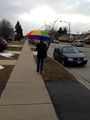
lrbrink90 with the umbrella. You can see the ground better in this one which matches up with the Google Maps spot.
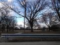
The unimpressive Oriole Park
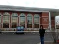
The impressive library
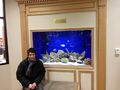
The aquarium in the library


Achievements
zhukant earned the Drag-along achievement
|
zhukant and lrbrink90 earned the Land geohash achievement
|