Difference between revisions of "2013-02-20 55 37"
imported>Московская правда (→Participants) |
m |
||
| (30 intermediate revisions by 4 users not shown) | |||
| Line 1: | Line 1: | ||
| − | |||
<!-- If you did not specify these parameters in the template, please substitute appropriate values for IMAGE, LAT, LON, and DATE (YYYY-MM-DD format) | <!-- If you did not specify these parameters in the template, please substitute appropriate values for IMAGE, LAT, LON, and DATE (YYYY-MM-DD format) | ||
| Line 15: | Line 14: | ||
}} | }} | ||
| − | |||
__NOTOC__ | __NOTOC__ | ||
== Location == | == Location == | ||
| − | The place | + | The place is easy to reach. It is right beside the main Moscow-Minsk highway just south of the suburban town Odintsovo. |
== Participants == | == Participants == | ||
| Line 24: | Line 22: | ||
== Plans == | == Plans == | ||
| − | + | This was a fairly simple expedition: head to Odintsovo then follow the main street south from the railway station till it joins the highway. | |
== Expedition == | == Expedition == | ||
| − | + | Turns out this was a Tron achievement: South from Odintsovo station. West from the hash to Lesnoy Gorodok. Home from there. A fairly simple circular route. | |
| + | |||
| + | Odinstovo seen from the railway station. You can see the buses and the yellow pyramids on top of the building on Google maps | ||
| + | |||
| + | The road south from Odintsovo railway station, ulitsa Verkhne-Proletarskaya, crosses a stream. The stream is marked on Google maps but not Openstreetmap.org. | ||
| + | |||
| + | The maps say follow ulitsa Verkhne-Proletarskaya but signage on the ground has it as ulitsa Markovskogo - улица Марковского - not such a problem, there's only one road. Its emergence on the main highway can be seen just behind the tall trees in the center of the photo. The foot marks are not mine! Someone's played Amundsen to my Scott. | ||
| + | |||
| + | Московская правда followed in the footsteps - which works out well as Московская правда doesn't have GPS to get the exact spot. Proof by induction: if evidence of the first party emerges, then I've got proof too. Note the newspaper's date, 20 Fevralya, and the date of upload (also 20 Feb.) | ||
| + | |||
== Tracklog == | == Tracklog == | ||
| − | + | [[File:Map 2013-02-20 55 37.png|thumbnail|250px|A pleasant stroll. Entered from Odintsovo station, walked south to hash (marked green), then took bus (marked red) to Lesnoy Gorodok station.]] | |
| + | I don't have a GPS but I do have www.openstreetmap.org and MS paint. See map. | ||
== Photos == | == Photos == | ||
| Line 37: | Line 45: | ||
--> | --> | ||
<gallery perrow="5"> | <gallery perrow="5"> | ||
| + | |||
| + | File:Odintsovo.jpg|Odinstovo seen from the railway station. You can see the buses and the yellow pyramids on top of the building on Google maps | ||
| + | |||
| + | File:Верхне-Пролетарская улица, Одинцово.jpg|The road south from Odintsovo railway station, ulitsa Verkhne-Proletarskaya, crosses a stream. The stream is marked on Google maps but not Openstreetmap.org. | ||
| + | |||
| + | File:Beaten to it.JPG|The maps say follow ulitsa Verkhne-Proletarskaya but signage on the ground has it as ulitsa Markovskogo - улица Марковского - not such a problem, there's only one road. Its emergence on the main highway can be seen just behind the tall trees in the center of the photo. The foot marks are not mine! Someone's played Amundsen to my Scott. | ||
| + | |||
| + | File:Московская правда hash 2013-02-20.JPG|Московская правда followed in the footsteps - which works out well as Московская правда doesn't have GPS to get the exact spot. Proof by induction: if evidence of the first party emerges, then I've got proof too. Note the newspaper's date, 20 Fevralya, and the date of upload (also 20 Feb.) | ||
| + | |||
| + | File:Aftermath Moscow 2013-02-20.JPG|Московская правда is still sitting in the snow. Maybe someone else will geohash today! | ||
| + | |||
</gallery> | </gallery> | ||
== Achievements == | == Achievements == | ||
{{#vardefine:ribbonwidth|800px}} | {{#vardefine:ribbonwidth|800px}} | ||
| − | |||
| + | {{Template:Land_geohash | ||
| + | | latitude = 55 | ||
| + | | longitude = 37 | ||
| + | | date = 2013-02-20 | ||
| + | | name = Московская правда | ||
| + | }} | ||
| + | {{Template:Tron | ||
| + | | latitude = 55 | ||
| + | | longitude = 37 | ||
| + | | date = 2013-02-20 | ||
| + | | tracklog = | ||
| + | | possessive =its | ||
| + | | name = Московская правда | ||
| + | | image = Map 2013-02-20 55 37.png | ||
| + | }} | ||
| + | {{No_batteries_geohash | ||
| + | | latitude = 55 | ||
| + | | longitude = 37 | ||
| + | | date = 2013-02-20 | ||
| + | | name = Московская правда | ||
| + | }} | ||
| + | {{Public transport geohash | ||
| + | | latitude = 55 | ||
| + | | longitude = 37 | ||
| + | | date = 2013-02-20 | ||
| + | | busline = | ||
| + | | name = Московская правда | ||
| + | | image = Map 2013-02-20 55 37.png | ||
| + | }} | ||
| − | |||
| − | |||
| − | |||
| − | |||
| − | |||
| − | |||
| − | |||
| − | |||
| − | |||
| − | |||
[[Category:Expeditions]] | [[Category:Expeditions]] | ||
| − | |||
[[Category:Expeditions with photos]] | [[Category:Expeditions with photos]] | ||
| − | + | [[Category:Expedition without GPS]] | |
| − | [[Category:Expedition without GPS]] | ||
| − | |||
| − | |||
| − | |||
[[Category:Coordinates reached]] | [[Category:Coordinates reached]] | ||
| − | + | {{location|RU|MOS}} | |
| − | |||
| − | |||
| − | |||
| − | |||
| − | |||
| − | |||
| − | |||
| − | |||
| − | |||
| − | |||
| − | |||
| − | |||
| − | |||
| − | |||
| − | |||
| − | |||
| − | |||
| − | |||
| − | |||
Latest revision as of 11:06, 22 September 2021
| Wed 20 Feb 2013 in 55,37: 55.6554927, 37.2887369 geohashing.info google osm bing/os kml crox |
Location
The place is easy to reach. It is right beside the main Moscow-Minsk highway just south of the suburban town Odintsovo.
Participants
Московская правда arrived to find evidence of previous geohashers.
Plans
This was a fairly simple expedition: head to Odintsovo then follow the main street south from the railway station till it joins the highway.
Expedition
Turns out this was a Tron achievement: South from Odintsovo station. West from the hash to Lesnoy Gorodok. Home from there. A fairly simple circular route.
Odinstovo seen from the railway station. You can see the buses and the yellow pyramids on top of the building on Google maps
The road south from Odintsovo railway station, ulitsa Verkhne-Proletarskaya, crosses a stream. The stream is marked on Google maps but not Openstreetmap.org.
The maps say follow ulitsa Verkhne-Proletarskaya but signage on the ground has it as ulitsa Markovskogo - улица Марковского - not such a problem, there's only one road. Its emergence on the main highway can be seen just behind the tall trees in the center of the photo. The foot marks are not mine! Someone's played Amundsen to my Scott.
Московская правда followed in the footsteps - which works out well as Московская правда doesn't have GPS to get the exact spot. Proof by induction: if evidence of the first party emerges, then I've got proof too. Note the newspaper's date, 20 Fevralya, and the date of upload (also 20 Feb.)
Tracklog

I don't have a GPS but I do have www.openstreetmap.org and MS paint. See map.
Photos
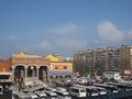
Odinstovo seen from the railway station. You can see the buses and the yellow pyramids on top of the building on Google maps
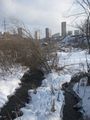
The road south from Odintsovo railway station, ulitsa Verkhne-Proletarskaya, crosses a stream. The stream is marked on Google maps but not Openstreetmap.org.
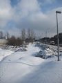
The maps say follow ulitsa Verkhne-Proletarskaya but signage on the ground has it as ulitsa Markovskogo - улица Марковского - not such a problem, there's only one road. Its emergence on the main highway can be seen just behind the tall trees in the center of the photo. The foot marks are not mine! Someone's played Amundsen to my Scott.
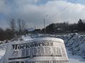
Московская правда followed in the footsteps - which works out well as Московская правда doesn't have GPS to get the exact spot. Proof by induction: if evidence of the first party emerges, then I've got proof too. Note the newspaper's date, 20 Fevralya, and the date of upload (also 20 Feb.)
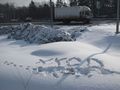
Московская правда is still sitting in the snow. Maybe someone else will geohash today!


Achievements
Московская правда earned the Land geohash achievement
|
Московская правда earned the Tron achievement
|
Московская правда earned the No Batteries Geohash Achievement
|
Московская правда earned the Public transport geohash achievement
|