Difference between revisions of "2013-02-22 49 9"
imported>Chemluth |
imported>Benjw m (→Photos: moved files) |
||
| Line 42: | Line 42: | ||
--> | --> | ||
<gallery perrow="5"> | <gallery perrow="5"> | ||
| − | Image: | + | Image:2013-02-22 49 9 Lambda.jpg | The Lambda sign i left. (Yes i´m a half-life fan) |
| − | Image:2013-02-22 49 | + | Image:2013-02-22 49 9 Me.jpg | not really a proof |
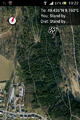
Image:2013-02-22 49 9 Sat.png | Image:2013-02-22 49 9 Sat.png | ||
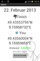
Image:2013-02-22 49 9 Droid.png | Image:2013-02-22 49 9 Droid.png | ||
Revision as of 01:47, 14 May 2013
| Fri 22 Feb 2013 in 49,9: 49.4355380, 9.1595873 geohashing.info google osm bing/os kml crox |
Location
The geohash was on a steep bank of a small stream 30 down from the trail near Fahrenbach.
Participants
Plans
I planned to make this Geohash during my lunchbreak because it was only nine Kilometers away. But them my break was cut short and i did it in the evening.
Expedition
I parked my car in Fahrenbach in a street called Wandelgewann (medival german for "places for just wandering around") and quickly fund the forest trail that i´ve seen on the satalite pictures. After a few minutes of walking I had to leaf the trail and go down the bank of the stream. The hashpoint was just above the stream. I the point would have been 5 meters further down the bank i could have claimed a achiefment for extremly cold wet feet.
Tracklog
Photos
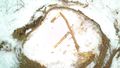
The Lambda sign i left. (Yes i´m a half-life fan)

not really a proof


Achievements
I could claim "Land geohash achievment" because it was my first geohash, but i forgot to collect the required proof. I only have a screenshot of Geohashdroid, some photos and I left a lambda sign on the hashpoint.