Difference between revisions of "2013-02-22 49 9"
imported>Chemluth |
imported>FippeBot m (Location) |
||
| (4 intermediate revisions by 3 users not shown) | |||
| Line 15: | Line 15: | ||
}} | }} | ||
| − | + | ||
__NOTOC__ | __NOTOC__ | ||
== Location == | == Location == | ||
| − | + | ||
| − | + | On a steep bank of a small stream 30 down from the trail near Fahrenbach. | |
| + | |||
== Participants == | == Participants == | ||
| − | only me [[User:Chemluth|Chemluth]] | + | * only me [[User:Chemluth|Chemluth]] |
| − | |||
| − | |||
== Plans == | == Plans == | ||
| − | I planned to make this Geohash during my | + | I planned to make this Geohash during my lunch break because it was only nine Kilometers away. But them my break was cut short and I did it in the evening. |
| − | + | ||
== Expedition == | == Expedition == | ||
| − | I parked my car in Fahrenbach in a street called Wandelgewann ( | + | I parked my car in Fahrenbach in a street called Wandelgewann (medieval German for "places for just wandering around") and quickly found the forest trail that I saw on the satellite pictures. After a few minutes of walking I had to leave the trail and go down the bank of the stream. The hashpoint was just above the stream. If the point had been 5 meters further down the bank I could have claimed an achievement for extremely cold wet feet. |
| − | + | ||
== Tracklog == | == Tracklog == | ||
| Line 38: | Line 37: | ||
== Photos == | == Photos == | ||
| − | + | ||
| − | |||
| − | |||
<gallery perrow="5"> | <gallery perrow="5"> | ||
| − | Image: | + | Image:2013-02-22 49 9 Lambda.jpg | The Lambda sign I left. (Yes I´m a half-life fan) |
| − | Image:2013-02-22 49 | + | Image:2013-02-22 49 9 Me.jpg | not really a proof |
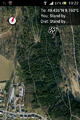
Image:2013-02-22 49 9 Sat.png | Image:2013-02-22 49 9 Sat.png | ||
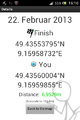
Image:2013-02-22 49 9 Droid.png | Image:2013-02-22 49 9 Droid.png | ||
| Line 49: | Line 46: | ||
== Achievements == | == Achievements == | ||
| − | I could claim "Land geohash achievment" because it was my first geohash, but | + | I could claim "Land geohash achievment" because it was my first geohash, but I forgot to collect the required proof. I only have a screenshot of Geohashdroid, some photos and I left a lambda sign on the hashpoint. |
| + | :I don't think anyone is going to object to your claiming it [[User:Jiml|Jiml]] ([[User talk:Jiml|talk]]) 07:43, 15 May 2013 (EDT) | ||
| + | |||
{{#vardefine:ribbonwidth|800px}} | {{#vardefine:ribbonwidth|800px}} | ||
<!-- Add any achievement ribbons you earned below, or remove this section --> | <!-- Add any achievement ribbons you earned below, or remove this section --> | ||
| + | * Land geohash | ||
| − | |||
| − | |||
| − | |||
| − | |||
| − | |||
| − | |||
| − | |||
| − | |||
[[Category:Expeditions]] | [[Category:Expeditions]] | ||
| − | + | ||
[[Category:Expeditions with photos]] | [[Category:Expeditions with photos]] | ||
| − | + | ||
| − | |||
| − | |||
| − | |||
| − | |||
[[Category:Coordinates reached]] | [[Category:Coordinates reached]] | ||
| − | + | {{location|DE|BW|BCH}} | |
| − | |||
| − | |||
| − | |||
| − | |||
| − | |||
| − | |||
| − | |||
| − | |||
| − | |||
| − | |||
| − | |||
| − | |||
| − | |||
| − | |||
| − | |||
| − | |||
| − | |||
Latest revision as of 01:05, 14 August 2019
| Fri 22 Feb 2013 in 49,9: 49.4355380, 9.1595873 geohashing.info google osm bing/os kml crox |
Location
On a steep bank of a small stream 30 down from the trail near Fahrenbach.
Participants
- only me Chemluth
Plans
I planned to make this Geohash during my lunch break because it was only nine Kilometers away. But them my break was cut short and I did it in the evening.
Expedition
I parked my car in Fahrenbach in a street called Wandelgewann (medieval German for "places for just wandering around") and quickly found the forest trail that I saw on the satellite pictures. After a few minutes of walking I had to leave the trail and go down the bank of the stream. The hashpoint was just above the stream. If the point had been 5 meters further down the bank I could have claimed an achievement for extremely cold wet feet.
Tracklog
Photos
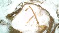
The Lambda sign I left. (Yes I´m a half-life fan)

not really a proof


Achievements
I could claim "Land geohash achievment" because it was my first geohash, but I forgot to collect the required proof. I only have a screenshot of Geohashdroid, some photos and I left a lambda sign on the hashpoint.
- Land geohash