Difference between revisions of "2013-02-23 38 -121"
imported>Lucky91xj (Created page with "{{subst:Expedition |lat = latitude of graticule |lon = longitude of graticule |date = date of expedition, in YYYY-MM-DD format }}") |
(remove redundant category) |
||
| (11 intermediate revisions by 3 users not shown) | |||
| Line 1: | Line 1: | ||
| − | |||
<!-- If you did not specify these parameters in the template, please substitute appropriate values for IMAGE, LAT, LON, and DATE (YYYY-MM-DD format) | <!-- If you did not specify these parameters in the template, please substitute appropriate values for IMAGE, LAT, LON, and DATE (YYYY-MM-DD format) | ||
| Line 10: | Line 9: | ||
--> | --> | ||
{{meetup graticule | {{meetup graticule | ||
| − | | lat= | + | | lat=38 |
| − | | lon= | + | | lon=-121 |
| − | | date= | + | | date=2013-02-23 |
}} | }} | ||
| Line 18: | Line 17: | ||
__NOTOC__ | __NOTOC__ | ||
== Location == | == Location == | ||
| − | + | Strawberry stand in Lincoln, CA | |
== Participants == | == Participants == | ||
| − | < | + | *[[User:Lucky91xj|Lucky91xj]]<br> |
| − | |||
== Plans == | == Plans == | ||
| − | + | Trying for a late morning hash | |
== Expedition == | == Expedition == | ||
| − | + | Got as close to the hash as possible (38.926753,-121.282352) at about 9:30 am PST, but my GPS didn't seem to want to find the exact location. That, and I probably don't know how to use it correctly. I think I can count this as successful, due to my margin of error being about 4 feet. If I'm wrong, please correct me. I also left a marker nailed to a piece of scrap wood against the fence that blocked my efforts. There weren't any "No Trespassing" signs, but this is bull and shotgun territory, so I decided not to hop it. It was really gorgeous out there, with blue skies and white, fluffy clouds. Sadly, no one else was there. Not bad for my closest attempt yet! | |
| − | |||
| − | |||
| − | |||
== Photos == | == Photos == | ||
| Line 38: | Line 33: | ||
--> | --> | ||
<gallery perrow="5"> | <gallery perrow="5"> | ||
| + | Marker against fence close up.jpeg | Marker | ||
| + | Marker against fence.jpg | Local area of hash | ||
| + | Lucky91xj pointing to guess at hashy spot.jpeg | Lucky91xj pointing at estimation of hashpoint | ||
</gallery> | </gallery> | ||
| − | |||
| − | |||
| − | |||
| − | |||
| − | |||
| − | |||
| − | |||
| − | |||
| − | |||
| − | |||
| − | |||
| − | |||
| − | |||
| − | |||
| − | |||
[[Category:Expeditions]] | [[Category:Expeditions]] | ||
| − | |||
[[Category:Expeditions with photos]] | [[Category:Expeditions with photos]] | ||
| − | |||
| − | |||
| − | |||
| − | |||
| − | |||
[[Category:Coordinates reached]] | [[Category:Coordinates reached]] | ||
| − | + | {{location|US|CA|PA}} | |
| − | |||
| − | |||
| − | |||
| − | |||
| − | |||
| − | |||
| − | |||
| − | |||
| − | |||
| − | |||
| − | |||
| − | |||
| − | |||
| − | |||
| − | |||
| − | |||
| − | |||
Latest revision as of 13:32, 3 July 2022
| Sat 23 Feb 2013 in 38,-121: 38.9267484, -121.2823594 geohashing.info google osm bing/os kml crox |
Location
Strawberry stand in Lincoln, CA
Participants
Plans
Trying for a late morning hash
Expedition
Got as close to the hash as possible (38.926753,-121.282352) at about 9:30 am PST, but my GPS didn't seem to want to find the exact location. That, and I probably don't know how to use it correctly. I think I can count this as successful, due to my margin of error being about 4 feet. If I'm wrong, please correct me. I also left a marker nailed to a piece of scrap wood against the fence that blocked my efforts. There weren't any "No Trespassing" signs, but this is bull and shotgun territory, so I decided not to hop it. It was really gorgeous out there, with blue skies and white, fluffy clouds. Sadly, no one else was there. Not bad for my closest attempt yet!
Photos
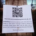
Marker
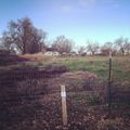
Local area of hash
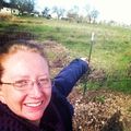
Lucky91xj pointing at estimation of hashpoint


