Difference between revisions of "2013-02-25 36 -80"
imported>Birdray m |
imported>Birdray |
||
| Line 10: | Line 10: | ||
== Participants == | == Participants == | ||
| − | [[User:Birdray|Birdray]] | + | [[User:Birdray|Birdray]] |
== Plans == | == Plans == | ||
| − | [[User:Birdray|Birdray]] | + | [[User:Birdray|Birdray]] intends to head out sometime after dinnertime, tracklogging on the way. Bringing the camera this time to see if I can get photo proof today. |
== Expedition == | == Expedition == | ||
| − | + | The first thing I did was put on my hiking boots. Man, my hiking boots are awesome. I don't know why I ever take them off. They seemed like a wise thing to wear to a field in the dark after some recent rain. | |
| + | |||
| + | It was already dark when I set out. The trip there was uneventful right up until I got to the end of my route on Reynolda--up ahead at the top of the hill I saw the silhouette of a deer cautiously crossing the road. It made it across, and as I got closer, another deer burst out of the brush and followed the first. I started watching the brush, and (thankfully still an ample distance ahead of me) a third deer ran out and followed the first two. I was aware there were deer in town, but hadn't actually seen any since I moved here--it was neat to see. (Not long after, I saw a mailbox silhouetted on the side of the road and was momentarily convinced there were deer ''everywhere''.) | ||
| + | |||
| + | I approached the hashpoint from the opposite side of the road. I started to pull off on the side of the road, then eyed the ditch and remembered how wet the ground has been, and promptly thought better of that. I pulled ahead to a driveway, turned around, and pulled off on the correct side of the road, which was at least on an upslope. I pulled off as far as I felt comfortable doing, but I was still pretty close to the road for comfort. It was quite dark at that point, with little to no lighting in the area, and very few cars. I got out and walked to the hashpoint. I briefly pondered taking a photograph with some proof, but it was--well. Take a look at the picture. It was that, in the dark, nearly a Frozen Geohash, and I was by myself with two hands and a device in each. NNNOPE. | ||
| + | |||
| + | I got back in the car and pulled back onto the road. That's the second off-road geohash in my car in two days. I'm gonna need an undercarriage wash. | ||
| + | |||
| + | On the way back, I stopped at a Taco Bell to grab some dinner, and a drugstore to pick up a couple things. The cashier recognized the university from my sweatshirt, and we commiserated about being fans of the place in enemy territory. | ||
| + | |||
| + | This time, my phone made it all the way home without crashing. | ||
== Tracklog == | == Tracklog == | ||
| − | + | [http://www.everytrail.com/view_trip.php?trip_id=2030270 My tracklog on EveryTrail] | |
== Photos == | == Photos == | ||
| − | |||
| − | |||
| − | |||
<gallery perrow="5"> | <gallery perrow="5"> | ||
| + | Image:2013-02-25_36_-80.jpg | Screenshot of the hashpoint reached | ||
| + | Image:2013-02-25_36_-80_2.jpg | A view of the hashpoint from my car. Inviting, eh? | ||
</gallery> | </gallery> | ||
== Achievements == | == Achievements == | ||
{{#vardefine:ribbonwidth|800px}} | {{#vardefine:ribbonwidth|800px}} | ||
| − | + | {{consecutive geohash | |
| + | | count = 2 | ||
| + | | latitude = 35 | ||
| + | | longitude = -79 | ||
| + | | date = 2012-02-25 | ||
| + | | name = Birdray | ||
| + | }} | ||
| − | |||
| − | |||
| − | |||
| − | |||
| − | |||
| − | |||
[[Category:Expeditions]] | [[Category:Expeditions]] | ||
| − | |||
[[Category:Expeditions with photos]] | [[Category:Expeditions with photos]] | ||
| − | |||
| − | |||
| − | |||
| − | |||
| − | |||
[[Category:Coordinates reached]] | [[Category:Coordinates reached]] | ||
| − | |||
| − | |||
| − | |||
| − | |||
| − | |||
| − | |||
| − | |||
| − | |||
| − | |||
| − | |||
| − | |||
| − | |||
| − | |||
| − | |||
| − | |||
| − | |||
| − | |||
| − | |||
Revision as of 02:26, 26 February 2013
| Mon 25 Feb 2013 in 36,-80: 36.1556592, -80.3842892 geohashing.info google osm bing/os kml crox |
Location
Just to the south of Skylark Rd. in Pfafftown.
Participants
Plans
Birdray intends to head out sometime after dinnertime, tracklogging on the way. Bringing the camera this time to see if I can get photo proof today.
Expedition
The first thing I did was put on my hiking boots. Man, my hiking boots are awesome. I don't know why I ever take them off. They seemed like a wise thing to wear to a field in the dark after some recent rain.
It was already dark when I set out. The trip there was uneventful right up until I got to the end of my route on Reynolda--up ahead at the top of the hill I saw the silhouette of a deer cautiously crossing the road. It made it across, and as I got closer, another deer burst out of the brush and followed the first. I started watching the brush, and (thankfully still an ample distance ahead of me) a third deer ran out and followed the first two. I was aware there were deer in town, but hadn't actually seen any since I moved here--it was neat to see. (Not long after, I saw a mailbox silhouetted on the side of the road and was momentarily convinced there were deer everywhere.)
I approached the hashpoint from the opposite side of the road. I started to pull off on the side of the road, then eyed the ditch and remembered how wet the ground has been, and promptly thought better of that. I pulled ahead to a driveway, turned around, and pulled off on the correct side of the road, which was at least on an upslope. I pulled off as far as I felt comfortable doing, but I was still pretty close to the road for comfort. It was quite dark at that point, with little to no lighting in the area, and very few cars. I got out and walked to the hashpoint. I briefly pondered taking a photograph with some proof, but it was--well. Take a look at the picture. It was that, in the dark, nearly a Frozen Geohash, and I was by myself with two hands and a device in each. NNNOPE.
I got back in the car and pulled back onto the road. That's the second off-road geohash in my car in two days. I'm gonna need an undercarriage wash.
On the way back, I stopped at a Taco Bell to grab some dinner, and a drugstore to pick up a couple things. The cashier recognized the university from my sweatshirt, and we commiserated about being fans of the place in enemy territory.
This time, my phone made it all the way home without crashing.
Tracklog
Photos
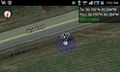
Screenshot of the hashpoint reached
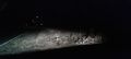
A view of the hashpoint from my car. Inviting, eh?


Achievements
Birdray earned the Consecutive geohash achievement
|