Difference between revisions of "2013-02-28 47 11"
imported>Zertrin (coords reached) |
imported>Zertrin (Another success !) |
||
| Line 1: | Line 1: | ||
| − | |||
| − | |||
| − | |||
| − | |||
| − | |||
| − | |||
| − | |||
| − | |||
| − | |||
| − | |||
{{meetup graticule | {{meetup graticule | ||
| lat=47 | | lat=47 | ||
| Line 18: | Line 8: | ||
__NOTOC__ | __NOTOC__ | ||
== Location == | == Location == | ||
| − | + | Next to the Isar canal, close to Kloster Schäftlarn, 15 km south of Munich. | |
== Participants == | == Participants == | ||
| − | + | * [[User:Zertrin|Zertrin]] | |
| − | + | * [[User:vermouthandgin|vermouthandgin]] | |
== Plans == | == Plans == | ||
| − | + | Try to reach this hash before [[User:vermouthandgin|vermouthandgin]] took her plane to Singapore. | |
== Expedition == | == Expedition == | ||
| − | + | After packing all the luggage of [[User:vermouthandgin|vermouthandgin]] in the car we departed at 1 p.m. towards the hash. Once again with the motorway 95 we arrived quickly to the bridge over the Isar river where [[User:Zertrin|Zertrin]] had spotted that we ought to park. There was a restaurant next to the bridge and its parking seemed the only acceptable place where to park so we decided to park there and to eat there (parking being usually for customers only, but we had to eat too so this wasn't a problem. | |
| + | |||
| + | After a good lunch we went to the hash. The amount of snow, like the two previous expeditions, made the last meters to reach the hashpoint more adventurous. This time somme more difficulty was added by the fact that the hash was 10 meters away from the nearest path, on a sloppy (and slippy) terrain. | ||
| + | |||
| + | Some geohashing dance in the deep snow later, the GPS finally decided we were at the point, we took the usual pictures and then headed back to the car as the time was running. | ||
| + | |||
| + | We made it in time to Munich's airport on the other side of Munich where [[User:vermouthandgin|vermouthandgin]] took her plane. | ||
== Tracklog == | == Tracklog == | ||
| Line 34: | Line 30: | ||
== Photos == | == Photos == | ||
| − | < | + | <gallery perrow="4"> |
| − | Image: | + | Image:2013-02-28 47 11 Zertrin - Gasthaus zum Bruckenfischer.JPG | The restaurant: Gasthaus zum Bruckenfischer |
| − | -- | + | Image:2013-02-28 47 11 Zertrin - towards hashpoint.JPG | Downward to the hash |
| − | + | Image:2013-02-28 47 11 Zertrin - GPS Coords.JPG | Coordinates reached :) | |
| + | Image:2013-02-28 47 11 Zertrin - vermouthandgin and Zertrin at hashpoint.JPG | [[User:vermouthandgin|vermouthandgin]] and [[User:Zertrin|Zertrin]] at the hashpoint | ||
| + | Image:2013-02-28 47 11 Zertrin - around haspoint 1.JPG | Around the hashpoint... | ||
| + | Image:2013-02-28 47 11 Zertrin - around haspoint 2.JPG | ... sloppy terrain and trees... | ||
| + | Image:2013-02-28 47 11 Zertrin - vermouthandgin on the path near the hashpoint.JPG | [[User:vermouthandgin|vermouthandgin]] on the path near the hashpoint | ||
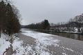
| + | Image:2013-02-28 47 11 Zertrin - Isar Canal on the left.JPG | The hashpoint lies between Isar river and Isar Canal | ||
| + | Image:2013-02-28 47 11 Zertrin - About the Isar Canal.JPG | About the Isar Canal | ||
| + | Image:2013-02-28 47 11 Zertrin - the Isar river.JPG | The Isar river | ||
| + | Image:2013-02-28 47 11 Zertrin - the Isar river 2.JPG | The Isar river (north side) | ||
| + | Image:2013-02-28 47 11 Zertrin - the Isar river 3.JPG | The Isar river (south side) | ||
</gallery> | </gallery> | ||
| Line 43: | Line 48: | ||
{{#vardefine:ribbonwidth|800px}} | {{#vardefine:ribbonwidth|800px}} | ||
<!-- Add any achievement ribbons you earned below, or remove this section --> | <!-- Add any achievement ribbons you earned below, or remove this section --> | ||
| + | {{consecutive geohash | count = 3 | latitude = 48 | longitude = 11 | date = 2013-02-26 | name = [[User:Zertrin|Zertrin]] and [[User:Vermouthandgin|vermouthandgin]] }} | ||
| + | {{Minesweeper geohash | graticule = München, Germany | ranknumber = 2 | e = true | s = true | name = [[User:Zertrin|Zertrin]] and [[User:Vermouthandgin|vermouthandgin]] }} | ||
| − | |||
| − | |||
| − | |||
| − | |||
| − | |||
| − | |||
| − | |||
| − | |||
| − | |||
| − | |||
| − | |||
[[Category:Expeditions]] | [[Category:Expeditions]] | ||
| − | + | [[Category:Expeditions with photos]] | |
| − | [[Category:Expeditions with photos]] | ||
| − | |||
| − | |||
| − | |||
| − | |||
| − | |||
[[Category:Coordinates reached]] | [[Category:Coordinates reached]] | ||
| − | |||
| − | |||
| − | |||
| − | |||
| − | |||
| − | |||
| − | |||
| − | |||
| − | |||
| − | |||
| − | |||
| − | |||
| − | |||
| − | |||
| − | |||
| − | |||
| − | |||
| − | |||
Revision as of 19:33, 28 February 2013
| Thu 28 Feb 2013 in 47,11: 47.9823602, 11.4796696 geohashing.info google osm bing/os kml crox |
Location
Next to the Isar canal, close to Kloster Schäftlarn, 15 km south of Munich.
Participants
Plans
Try to reach this hash before vermouthandgin took her plane to Singapore.
Expedition
After packing all the luggage of vermouthandgin in the car we departed at 1 p.m. towards the hash. Once again with the motorway 95 we arrived quickly to the bridge over the Isar river where Zertrin had spotted that we ought to park. There was a restaurant next to the bridge and its parking seemed the only acceptable place where to park so we decided to park there and to eat there (parking being usually for customers only, but we had to eat too so this wasn't a problem.
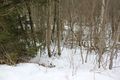
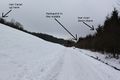
After a good lunch we went to the hash. The amount of snow, like the two previous expeditions, made the last meters to reach the hashpoint more adventurous. This time somme more difficulty was added by the fact that the hash was 10 meters away from the nearest path, on a sloppy (and slippy) terrain.
Some geohashing dance in the deep snow later, the GPS finally decided we were at the point, we took the usual pictures and then headed back to the car as the time was running.
We made it in time to Munich's airport on the other side of Munich where vermouthandgin took her plane.
Tracklog
Photos
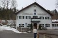
The restaurant: Gasthaus zum Bruckenfischer
Downward to the hash
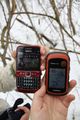
Coordinates reached :)

vermouthandgin and Zertrin at the hashpoint

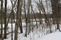
Around the hashpoint...
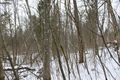
... sloppy terrain and trees...

vermouthandgin on the path near the hashpoint
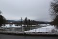
The hashpoint lies between Isar river and Isar Canal
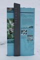
About the Isar Canal
The Isar river
The Isar river (north side)
The Isar river (south side)


Achievements
Zertrin and vermouthandgin earned the Consecutive geohash achievement
|
Zertrin and vermouthandgin achieved level 2 of the Minesweeper Geohash achievement
|