Difference between revisions of "2013-03-01 42 -115"
imported>Eldin |
m (per Renaming Proposal) |
||
| (9 intermediate revisions by 2 users not shown) | |||
| Line 1: | Line 1: | ||
| + | {{meetup graticule | lat=42 | lon=-115 | date=2013-03-01 }} | ||
| − | + | __NOTOC__ | |
| − | |||
| − | |||
| − | |||
| − | |||
| − | |||
== Location == | == Location == | ||
| − | |||
Just off highway 78, near the junction with highway 51 | Just off highway 78, near the junction with highway 51 | ||
| − | |||
== Participants == | == Participants == | ||
| − | + | [[User:Eldin | Eldin]] | |
| − | |||
| − | |||
== Plans == | == Plans == | ||
| + | Hoping to get the virgin graticule achieve here, and be back on the road by 10:30 PM in order to try to get the midnight geohash achievement for [[2013-03-02 43 -115]], which is somewhat nearby and somewhat on my way back home from this one. | ||
| − | |||
== Expedition == | == Expedition == | ||
| + | *Success! Hashpoint was reached. Cherry was popped. -- [[User:Eldin|Eldin]] ([[User talk:Eldin|talk]]) [http://www.openstreetmap.org/?lat=42.92484670&lon=-115.72110695&zoom=16&layers=B000FTF @42.9248,-115.7211] 22:11, 1 March 2013 (MST) | ||
| + | When I set out, the plan was to be done with this hash point no later than 10:30 PM, to ensure sufficient time to reach the next point in time for the midnight geohash ribbon. I was able to drive to within about 1/3 of a kilometer of the hash point. From where I parked, the only real trail went the wrong way to get to the hash point, but the sagebrush was relatively sparse, so it wasn't very difficult to make my way to the coordinates. | ||
| + | It was a beautiful night, with a clear sky full of stars, and not too cold out. And being almost 20 miles from the nearest city of even small size made for very little light pollution. I saw a few jackrabbits while I was walking to the coordinates, but they were too fast for me to get any pictures. I arrived at the correct coordinates at about 9:50pm. Since I had plenty of time to get to the next hash, I stopped, got my photographic proof, ate a hamburger, and just stood there looking up at the stars and listening to the coyotes howling in the distance for a few minutes. | ||
| − | + | At the end, I collected my things, and made my way back to the car to head out to the next hash. And once I got back to somewhere with data service, I posted a comment to indicate my success. | |
| − | |||
| − | |||
| − | |||
| − | |||
| − | <gallery perrow="5"> | + | == Photos == |
| + | <gallery perrow="5"> | ||
Image:2013 03 01-42 -115 proof.jpg | Proof that I was at the right place. | Image:2013 03 01-42 -115 proof.jpg | Proof that I was at the right place. | ||
| − | Image:2013 03 01 42 -115 grin.jpg | [[User:Eldin|Eldin]] grinning and eating a burger. | + | Image:2013 03 01 42 -115 grin.jpg | [[User:Eldin | Eldin]] grinning and eating a burger. |
| − | |||
| − | |||
</gallery> | </gallery> | ||
== Achievements == | == Achievements == | ||
{{#vardefine:ribbonwidth|800px}} | {{#vardefine:ribbonwidth|800px}} | ||
| + | {{Graticule unlocked | latitude = 42 | longitude = -115 | date = 2013-03-01 | name = [[User:Eldin | Eldin]] }} | ||
| + | {{Minesweeper geohash | graticule = Boise, Idaho | ranknumber = 1 | se = true | name = [[User:Eldin | Eldin]] }} | ||
| − | |||
| − | |||
| − | |||
| − | |||
| − | |||
| − | |||
| − | |||
| − | |||
| − | |||
| − | |||
[[Category:Expeditions]] | [[Category:Expeditions]] | ||
[[Category:Expeditions with photos]] | [[Category:Expeditions with photos]] | ||
[[Category:Coordinates reached]] | [[Category:Coordinates reached]] | ||
| + | {{location|US|ID|OW}} | ||
Latest revision as of 05:28, 20 March 2024
| Fri 1 Mar 2013 in 42,-115: 42.9283461, -115.7213111 geohashing.info google osm bing/os kml crox |
Location
Just off highway 78, near the junction with highway 51
Participants
Plans
Hoping to get the virgin graticule achieve here, and be back on the road by 10:30 PM in order to try to get the midnight geohash achievement for 2013-03-02 43 -115, which is somewhat nearby and somewhat on my way back home from this one.
Expedition
- Success! Hashpoint was reached. Cherry was popped. -- Eldin (talk) @42.9248,-115.7211 22:11, 1 March 2013 (MST)
When I set out, the plan was to be done with this hash point no later than 10:30 PM, to ensure sufficient time to reach the next point in time for the midnight geohash ribbon. I was able to drive to within about 1/3 of a kilometer of the hash point. From where I parked, the only real trail went the wrong way to get to the hash point, but the sagebrush was relatively sparse, so it wasn't very difficult to make my way to the coordinates.
It was a beautiful night, with a clear sky full of stars, and not too cold out. And being almost 20 miles from the nearest city of even small size made for very little light pollution. I saw a few jackrabbits while I was walking to the coordinates, but they were too fast for me to get any pictures. I arrived at the correct coordinates at about 9:50pm. Since I had plenty of time to get to the next hash, I stopped, got my photographic proof, ate a hamburger, and just stood there looking up at the stars and listening to the coyotes howling in the distance for a few minutes.
At the end, I collected my things, and made my way back to the car to head out to the next hash. And once I got back to somewhere with data service, I posted a comment to indicate my success.
Photos
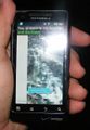
Proof that I was at the right place.
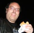
Eldin grinning and eating a burger.


Achievements
Eldin earned the Graticule Unlocked Achievement
|
Eldin achieved level 1 of the Minesweeper Geohash achievement
|