Difference between revisions of "2013-03-03 48 11"
imported>Mlk141081 (→Mlk141081) |
imported>Knallgöwer (→Knallgöwer) |
||
| Line 19: | Line 19: | ||
== Expedition == | == Expedition == | ||
<!-- how it all turned out. your narrative goes here. --> | <!-- how it all turned out. your narrative goes here. --> | ||
| − | === [[User: | + | === [[User:Knallgöwer|Knallgöwer]] === |
| − | *On my way there -- [[User: | + | *On my way there -- [[User:Knallgöwer|Knallgöwer]] ([[User talk:Knallgöwer|talk]]) [http://www.openstreetmap.org/?lat=48.13247670&lon=11.59903630&zoom=16&layers=B000FTF @48.1325,11.5990] 13:51, 3 March 2013 (CET) |
| − | *Yeah! I'm there! Reached my first geohash, awesome! -- [[User: | + | *Yeah! I'm there! Reached my first geohash, awesome! -- [[User:Knallgöwer|Knallgöwer]] ([[User talk:Knallgöwer|talk]]) [http://www.openstreetmap.org/?lat=48.01611184&lon=11.14428036&zoom=16&layers=B000FTF @48.0161,11.1443] 15:20, 3 March 2013 (CET) |
| − | *Fun! -- [[User: | + | *Fun! -- [[User:Knallgöwer|Knallgöwer]] ([[User talk:Knallgöwer|talk]]) [http://www.openstreetmap.org/?lat=48.01598089&lon=11.14439303&zoom=16&layers=B000FTF @48.0160,11.1444] 15:27, 3 March 2013 (CET) |
=== [[User:Zertrin|Zertrin]] === | === [[User:Zertrin|Zertrin]] === | ||
Revision as of 12:13, 9 March 2013
| Sun 3 Mar 2013 in 48,11: 48.0160004, 11.1443803 geohashing.info google osm bing/os kml crox |
Location
In the Rieder Wald, between Breitbrunn am Ammersee and Herrsching, 30 km SE of München
Participants
Plans
- @Mlk141081: Hey there, I plan to attempt it too, but a bit later today. Happy to see another new Geohasher in the graticule :) — Zertrin 09:32, 3 March 2013 (EST)
Expedition
Knallgöwer
- On my way there -- Knallgöwer (talk) @48.1325,11.5990 13:51, 3 March 2013 (CET)
- Yeah! I'm there! Reached my first geohash, awesome! -- Knallgöwer (talk) @48.0161,11.1443 15:20, 3 March 2013 (CET)
- Fun! -- Knallgöwer (talk) @48.0160,11.1444 15:27, 3 March 2013 (CET)
Zertrin
I was not sure to attempt this one, in any case only in the late afternoon. But when I saw that a new geohasher reached the hash around 3:30 p.m., it gave me the last bit of motivation I was lacking.
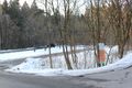
The day was perfect, blue sky with beautiful late winter sun, I guessed that, because the hash is close to the lake called Ammersee, I could have nice opportunities to make beautiful pictures.
I drove to the hash by car, parked on a nearby parking, and walked the 400 meters left through the forest. Approaching the hash I found the traces of the steps that Mlk141081 left in the snow, apparently coming from another direction.
I reached the hash easily, took some pictures and headed back to the parking following Mlk141081 steps. From there I went in the opposite direction of the hash, to reach the shore of the lake. Once there I took plenty of pictures of the setting sun over the lake.
Finally I went back to the car and drove uneventfully back home.
Tracklog
Photos
Mlk141081
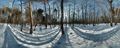
Panorama Photo of the Geohash

Zertrin
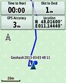
Coordinates reached :)
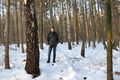
Zertrin at the coordinates
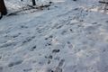
Mlk141081's steps
The nearby parking
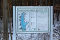
Map of the Lake Ammersee


Achievements
Mlk141081 and Zertrin earned the Land geohash achievement
|