Difference between revisions of "2013-03-04 51 5"
From Geohashing
imported>Eupeodes |
imported>GeorgDerReisende |
||
| Line 1: | Line 1: | ||
| − | |||
| − | |||
| − | |||
| − | |||
| − | |||
| − | |||
| − | |||
| − | |||
| − | |||
| − | |||
{{meetup graticule | {{meetup graticule | ||
| lat=51 | | lat=51 | ||
| Line 71: | Line 61: | ||
[[Category:Eupeodes]] | [[Category:Eupeodes]] | ||
| − | |||
| − | |||
| − | |||
[[Category:Expeditions]] | [[Category:Expeditions]] | ||
| − | + | ||
[[Category:Expeditions with photos]] | [[Category:Expeditions with photos]] | ||
| − | + | ||
| − | |||
| − | |||
| − | |||
| − | |||
[[Category:Coordinates reached]] | [[Category:Coordinates reached]] | ||
| − | |||
| − | |||
| − | |||
| − | |||
| − | |||
| − | |||
| − | |||
| − | |||
| − | |||
| − | |||
| − | |||
| − | |||
| − | |||
| − | |||
| − | |||
| − | |||
| − | |||
| − | |||
Revision as of 23:00, 15 November 2014
| Mon 4 Mar 2013 in 51,5: 51.9085313, 5.4518289 geohashing.info google osm bing/os kml crox |
Location
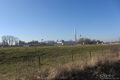
Near Tiel on the cycle path along a road along the Amsterdam-Rhine Channel
Participants
Eupeodes is planning to go as third in a row of at least 3.
Expedition
Eupeodes left his home around 13:30 with his recumbent bike. The GPS told the hash was 15 km from home in a straight line. Over the road it took almost 20 km and a ferry across the Rhine. Took some pictures and set of again, in the opposite direction of where I came from. Cycled some more, crossed the Rhine again by a different ferry and cycled back home. My total distance was 59.41 and it is a torn.
Tracklog
Will be uploaded later
Photos
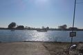
First ferry
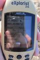
Proof
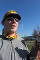
Grin
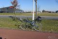
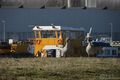
My bike
Geese
Geese
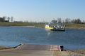
Second ferry


Achievements
Eupeodes earned the Consecutive bicycle tron land geohash Achievement
|