Difference between revisions of "2013-03-06 48 -3"
From Geohashing
imported>Ourlig (→Photos) |
imported>Ourlig |
||
| Line 45: | Line 45: | ||
--> | --> | ||
<gallery perrow="5"> | <gallery perrow="5"> | ||
| − | Image: | + | Image:2013_03_06_48_-3_hatandproof.JPG | No one else hat than mine, and the proof ! |
| − | Image: | + | Image:2013_03_06_48_-3_volcanosunset.JPG | This is _not_ an erupting volcano... |
| − | Image: | + | |
| − | + | Image:2013-03-06_48_-3_20-08-20-911.jpg | Me (and my hat) | |
| − | |||
</gallery> | </gallery> | ||
Revision as of 22:35, 14 January 2017
| Wed 6 Mar 2013 in 48,-3: 48.5990502, -3.5606729 geohashing.info google osm bing/os kml crox |
Location
In the middle of a field in the middle of nowhere (or near enough)...
Participants
Plans
Yggodin : No real plan here... Remembered to check the hash point for today when leaving work, and here I went.
Expedition
About 30 minutes travel in car (not counting the traffic jam in town). A road went almost all the way to the hash point (only 100m to do by foot).
- Here am I. Right on true spot. Nothing there except some trees, clouds and stuff... Posting photos as soon as I get home. -- Yggodin (talk) @48.5991,-3.5607 19:04, 6 March 2013 (CET)
Nothing more, really... Went back almost instantly, just enough time to take some pictures.
Tracklog
Photos
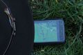
No one else hat than mine, and the proof !
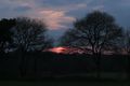
This is _not_ an erupting volcano...
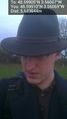
Me (and my hat)


