Difference between revisions of "2013-03-06 55 37"
From Geohashing
imported>Vb (Created page with "{{subst:Expedition |lat = 55 |lon = 37 |date = 2013-03-06 }}") |
imported>FippeBot m (Location) |
||
| (9 intermediate revisions by one other user not shown) | |||
| Line 19: | Line 19: | ||
== Location == | == Location == | ||
<!-- where you've surveyed the hash to be --> | <!-- where you've surveyed the hash to be --> | ||
| + | In Bitsevkiy forest park, Yasenevo side. | ||
== Participants == | == Participants == | ||
<!-- who attended: If you link to your wiki user name in this section, your expedition will be picked up by the various statistics generated for geohashing. You may use three tildes ~ as a shortcut to automatically insert the user signature of the account you are editing with. | <!-- who attended: If you link to your wiki user name in this section, your expedition will be picked up by the various statistics generated for geohashing. You may use three tildes ~ as a shortcut to automatically insert the user signature of the account you are editing with. | ||
--> | --> | ||
| − | + | [[User:Vb|vb]] | |
| − | |||
| − | |||
== Expedition == | == Expedition == | ||
<!-- how it all turned out. your narrative goes here. --> | <!-- how it all turned out. your narrative goes here. --> | ||
| + | 7,72km walk home-hash-home. | ||
| + | |||
| + | Temperature was about -2, so not having thermometer - not frozen. | ||
| + | |||
| + | Attempted tron, but miserably failed, by about 2m, navigating trails in the park. | ||
== Tracklog == | == Tracklog == | ||
<!-- if your GPS device keeps a log, you may post a link here --> | <!-- if your GPS device keeps a log, you may post a link here --> | ||
| + | [[Image:2013-03-06_55_37_Tracklog.jpg|250px]] | ||
== Photos == | == Photos == | ||
| Line 38: | Line 43: | ||
--> | --> | ||
<gallery perrow="5"> | <gallery perrow="5"> | ||
| + | Image:2013-03-06 55 37 06032013735.jpg | ~400m to the hash | ||
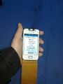
| + | Image:2013-03-06 55 37 06032013737.jpg | ~60m to the hash, new Metro station construction | ||
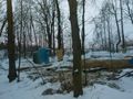
| + | Image:2013-03-06 55 37 06032013738.jpg | the hash was on the trail (to GPS precision) | ||
| + | Image:2013-03-06 55 37 06032013741.jpg | wrote XKCD, left marker | ||
</gallery> | </gallery> | ||
| Line 44: | Line 53: | ||
<!-- Add any achievement ribbons you earned below, or remove this section --> | <!-- Add any achievement ribbons you earned below, or remove this section --> | ||
| + | {{Walk geohash | latitude = 55 | longitude = 37 | date = 2013-03-06 | name = [[User:Vb|vb]] | distance = 7.72km | image = 2013-03-06_55_37_Tracklog.jpg }} | ||
| − | |||
| − | |||
| − | |||
| − | |||
| − | |||
| − | |||
| − | |||
| − | |||
| − | |||
| − | |||
[[Category:Expeditions]] | [[Category:Expeditions]] | ||
| − | |||
[[Category:Expeditions with photos]] | [[Category:Expeditions with photos]] | ||
| − | |||
| − | |||
| − | |||
| − | |||
| − | |||
[[Category:Coordinates reached]] | [[Category:Coordinates reached]] | ||
| − | + | [[Category:Land geohash achievement]] | |
| − | + | [[Category:Walk geohash achievement]] | |
| − | + | {{location|RU|MOW}} | |
| − | |||
| − | |||
| − | |||
| − | |||
| − | |||
| − | |||
| − | [[Category: | ||
| − | |||
| − | |||
| − | [[Category: | ||
| − | |||
| − | |||
| − | |||
| − | |||
| − | |||
Latest revision as of 01:18, 14 August 2019
| Wed 6 Mar 2013 in 55,37: 55.5990502, 37.5606729 geohashing.info google osm bing/os kml crox |
Location
In Bitsevkiy forest park, Yasenevo side.
Participants
Expedition
7,72km walk home-hash-home.
Temperature was about -2, so not having thermometer - not frozen.
Attempted tron, but miserably failed, by about 2m, navigating trails in the park.
Tracklog

Photos
~400m to the hash
~60m to the hash, new Metro station construction
the hash was on the trail (to GPS precision)
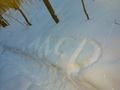
wrote XKCD, left marker


Achievements
vb earned the Walk geohash Achievement
|