Difference between revisions of "2013-03-07 52 7"
imported>Elwingelfje (→Participants) |
imported>FippeBot m (Location) |
||
| (5 intermediate revisions by 2 users not shown) | |||
| Line 9: | Line 9: | ||
And DON'T FORGET to add your expedition and the best photo you took to the gallery on the Main Page! We'd love to read your report, but that means we first have to discover it! :) | And DON'T FORGET to add your expedition and the best photo you took to the gallery on the Main Page! We'd love to read your report, but that means we first have to discover it! :) | ||
--> | --> | ||
| + | |||
{{meetup graticule | {{meetup graticule | ||
| lat=52 | | lat=52 | ||
| Line 15: | Line 16: | ||
}} | }} | ||
| − | + | ||
__NOTOC__ | __NOTOC__ | ||
== Location == | == Location == | ||
| Line 21: | Line 22: | ||
== Participants == | == Participants == | ||
| − | [[User:Elwingelfje|Elwingelfje]] | + | * [[User:Elwingelfje|Elwingelfje]] and her mom |
| + | * Juanita | ||
== Plans == | == Plans == | ||
| − | + | Drive to the edge of the forest, walk through the forest, discover what the odd tear / circle shaped structure is, catch the hash and go back home. Possibly do a multi-hash (which failed because the hash in the Enschede graticule was in the middle of a fenced meadow and I had no idea who was the owner and even if I had known I would've been too chicken to ask them permission anyway). | |
== Expedition == | == Expedition == | ||
| − | + | I always thought my parents looked upon geohashing as a somewhat silly hobby, a remnant of puberty and its unbridled spending of one's free time, so to speak. On Wednesday I was visiting my parents and staying the night, and I happened to show my mom the hash for Thursday, and that it wasn't that far away. She surprised me by saying: "Well, why don't we go there then? It would be a nice walk!" My thought exactly. She even seemed a little insulted when I said that I found her surprisingly adventurous: "Don't you think I am adventurous then, huh?" | |
| + | |||
| + | I won't bore you with our driving adventures. Suffice to say we didn't use a navigational device and found out to our shame that Google Maps doesn't show if crossing roads are level or not. We parked the car at the edge of the forest, near the 70. | ||
| + | |||
| + | It was a really nice walk! The weather wasn't too bad, even a bit of sun, and the forest was nice and a bit hilly, with singing birds. I also found out what the teardrop shaped weird railway looking thingy was - it's [[http://en.wikipedia.org/wiki/Transrapid this]], a high speed monorail test track called Transrapid. It's going to be demolished but we saw it in all its glory. Luckily it was on pillars so it didn't impede our progress. Wikipedia also just told me that something quite horrible happened there. In 2006 one of the trains doing a test run collided with a maintainance vehicle and 23 people were killed. The cause turned out to be a human error. | ||
| − | + | We left the forest again and came across a seriously smelly dung deposit. Then we walked a little further along the edge of the forest - and reached the hash! Yay! A picture was taken and happiness all around. And lots of streamers and confetti and... | |
| − | |||
== Photos == | == Photos == | ||
| − | |||
| − | |||
| − | |||
<gallery perrow="5"> | <gallery perrow="5"> | ||
| + | Image:2013-03-07_52_7_hashpoint.JPG | The hashpoint | ||
| + | Image:2013-03-07_52_7_meandmom.JPG | The hashers | ||
</gallery> | </gallery> | ||
== Achievements == | == Achievements == | ||
{{#vardefine:ribbonwidth|800px}} | {{#vardefine:ribbonwidth|800px}} | ||
| − | |||
| + | {{land geohash | ||
| + | | latitude = 52 | ||
| + | | longitude = 7 | ||
| + | | date = 2013-03-07 | ||
| + | | name = [[User:Elwingelfje|Elwingelfje]] and Juanita | ||
| + | }} | ||
| + | |||
| + | {{Border geohash achievement | ||
| + | | latitude = 52 | ||
| + | | longitude = 7 | ||
| + | | date = 2013-03-07 | ||
| + | | country1 = the Netherlands | ||
| + | | country2 = Germany | ||
| + | | name = [[User:Elwingelfje|Elwingelfje]] and Juanita | ||
| + | }} | ||
| + | |||
| + | {{drag-along | ||
| + | | latitude = 52 | ||
| + | | longitude = 7 | ||
| + | | date = 2013-03-07 | ||
| + | | partner = Juanita | ||
| + | | name = [[User:Elwingelfje|Elwingelfje]] | ||
| + | }} | ||
| − | + | {{Minesweeper geohash | |
| − | + | | graticule = Enschede, Netherlands | |
| − | + | | ranknumber = 2 | |
| + | | ne = true | ||
| + | | e = true | ||
| + | | w = true | ||
| + | | name = elwingelfje | ||
| + | }} | ||
| − | |||
| − | |||
| − | |||
| − | |||
| − | |||
[[Category:Expeditions]] | [[Category:Expeditions]] | ||
| − | |||
| − | |||
| − | |||
[[Category:Expedition without GPS]] | [[Category:Expedition without GPS]] | ||
| − | + | ||
| − | + | [[Category:Expeditions with photos]] | |
| − | |||
[[Category:Coordinates reached]] | [[Category:Coordinates reached]] | ||
| − | + | {{location|DE|NI|EL}} | |
| − | |||
| − | |||
| − | |||
| − | |||
| − | |||
| − | |||
| − | |||
| − | |||
| − | |||
| − | |||
| − | |||
| − | |||
| − | |||
| − | |||
| − | |||
| − | |||
| − | |||
Latest revision as of 05:38, 6 August 2019
| Thu 7 Mar 2013 in 52,7: 52.8385272, 7.3639408 geohashing.info google osm bing/os kml crox |
Location
Close to the town of Lathen, in Germany
Participants
- Elwingelfje and her mom
- Juanita
Plans
Drive to the edge of the forest, walk through the forest, discover what the odd tear / circle shaped structure is, catch the hash and go back home. Possibly do a multi-hash (which failed because the hash in the Enschede graticule was in the middle of a fenced meadow and I had no idea who was the owner and even if I had known I would've been too chicken to ask them permission anyway).
Expedition
I always thought my parents looked upon geohashing as a somewhat silly hobby, a remnant of puberty and its unbridled spending of one's free time, so to speak. On Wednesday I was visiting my parents and staying the night, and I happened to show my mom the hash for Thursday, and that it wasn't that far away. She surprised me by saying: "Well, why don't we go there then? It would be a nice walk!" My thought exactly. She even seemed a little insulted when I said that I found her surprisingly adventurous: "Don't you think I am adventurous then, huh?"
I won't bore you with our driving adventures. Suffice to say we didn't use a navigational device and found out to our shame that Google Maps doesn't show if crossing roads are level or not. We parked the car at the edge of the forest, near the 70.
It was a really nice walk! The weather wasn't too bad, even a bit of sun, and the forest was nice and a bit hilly, with singing birds. I also found out what the teardrop shaped weird railway looking thingy was - it's [this], a high speed monorail test track called Transrapid. It's going to be demolished but we saw it in all its glory. Luckily it was on pillars so it didn't impede our progress. Wikipedia also just told me that something quite horrible happened there. In 2006 one of the trains doing a test run collided with a maintainance vehicle and 23 people were killed. The cause turned out to be a human error.
We left the forest again and came across a seriously smelly dung deposit. Then we walked a little further along the edge of the forest - and reached the hash! Yay! A picture was taken and happiness all around. And lots of streamers and confetti and...
Photos
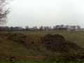
The hashpoint

The hashers


Achievements
Elwingelfje and Juanita earned the Land geohash achievement
|
Elwingelfje and Juanita earned the Border geohash achievement
|
Elwingelfje earned the Drag-along achievement
|
elwingelfje achieved level 2 of the Minesweeper Geohash achievement
|